MyTopo
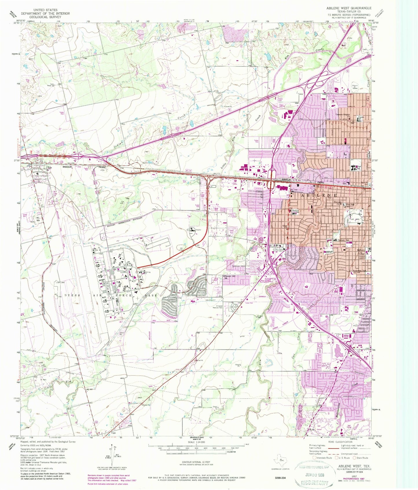
Classic USGS Abilene West Texas 7.5'x7.5' Topo Map
Couldn't load pickup availability
Historical USGS topographic quad map of Abilene West in the state of Texas. Map scale may vary for some years, but is generally around 1:24,000. Print size is approximately 24" x 27"
This quadrangle is in the following counties: Taylor.
The map contains contour lines, roads, rivers, towns, and lakes. Printed on high-quality waterproof paper with UV fade-resistant inks, and shipped rolled.
Contains the following named places: Abilene Baptist Church, Abilene Fire Department Station 6, Abilene Fire Department Station 7, Abilene Fire Department Station 8, Abilene High School, Ambler Baptist Church, Austin Elementary School, Bethel United Methodist Church, Blue Sox Sadium, Bonham Elementary School, Bonham School, Brook Hollow Christian Church of Christ, C W Gill Park, Cat Claw Creek, Church of Christ, Church of Christ - Baker Heights, Church of Christ - Minter Lane, Church of Christ - Southern Hills, Church of Christ - Westgate, Church of Christ - Woodlawn, Church of Christ - Wylie, City of Tye, Clack Middle School, Covenant Orthodox Presbyterian Church, Crescent Heights Baptist Church, Crescent Heights Church, Crocket School, Crockett Elementary School, Dyess Air Force Base, Dyess Air Force Base Post Office, Dyess Elementary School, Elliott - Hamil Garden of Memories Cemetery, Elmcrest Baptist Church, Elmwood Baptist Church, Elmwood Church, Elmwood Memorial Park, Fair Park, Fair Park School, Fairways Development Reservoir Number 2, Fairways Development Reservoir Number 2 Dam, Faith Baptist Church, Fannin Elementary School, Fannin School, Flying B Ranch Airstrip, Galilee Baptist Church, Gethsemani Spanish Assembly of God Church, Glad Tidings Assembly of God Church, Good Shepherd Baptist Mission Church, Grace Church, Grace Lutheran Church, Heritage Baptist Church, Highland Church of Christ, Holy Family Catholic Church, Indian Creek, Jackson Elementary School, Johnston Elementary School, KEYJ-AM (Abilene), KNTS-AM (Abilene), Lee Elementary School, Lighthouse Assembly of God Church, Little Elm Cemetery, Little Elm Creek, Long Elementary School, Madison Middle School, Mann Middle School, McMurry College Administration Building, MetroCare Services, New Beginnings Pentecostal Church, New Life Church of Christ, North Side Baptist Church, Northwest Church of Christ, Ortiz Elementary School, Oscar Rose Park, Our Savior Lutheran Church, Pleasant Hill School, Reagan Elementary School, Red Bud Park, Ridgemont Baptist Church, Saint James United Methodist Church, Saint Marks Episcopal Church, Saint Southwest Park Church, Scarborough Park, School Age Mothers Center - Abilene, Seventh Day Adventist Church, Southside Church of God, Southside Church of God in Christ, Southwest Park Baptist Church, Special Education Homebound, Texas Forest Service Abilene Office, Texas Highway Patrol Office - Abilene, Texas Parks and Wildlife Department Law Enforcement Division, Texas Rehabilitation Center, The Miracle Independent Baptist Church, Thomas L Blanton House, Truitt Davis Lake, Truitt Davis Lake Dam, Tye, Tye Cemetery, Tye Elementary School, Tye Police Department, Tye Post Office, Tye United Methodist Church, Tye Volunteer Fire Department, United Methodist Church - Elmwood West, United Pentecostal Church, Ward Elementary School, Westgate Towne Centre Shopping Center, Westminster Presbyterian Church, Westside Baptist Church, Wyndrock Baptist Church, Zion Lutheran Church, ZIP Codes: 79605, 79607