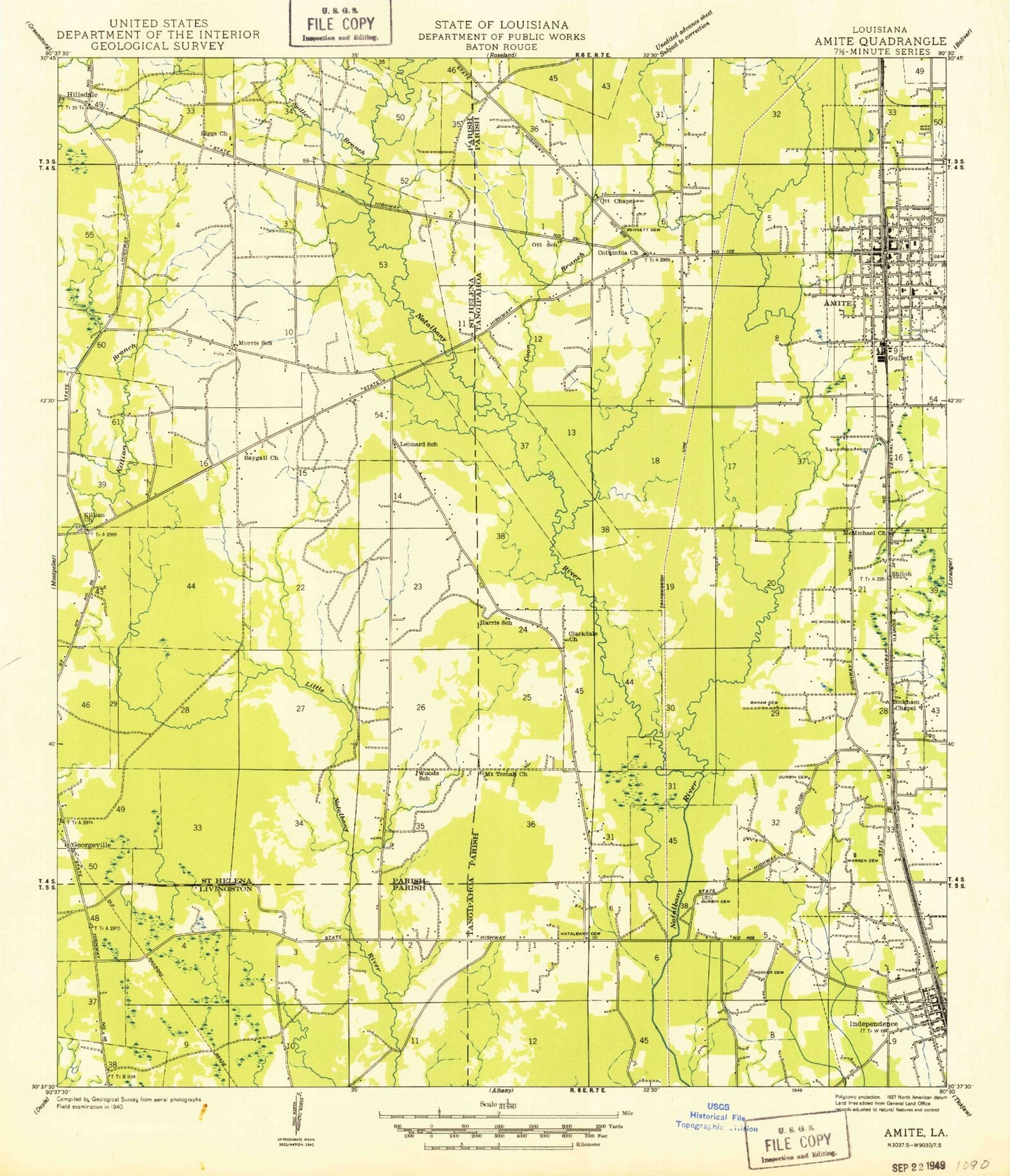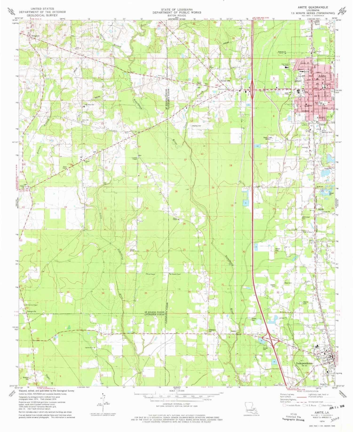

MyTopo
Classic USGS Amite Louisiana 7.5'x7.5' Topo Map
Couldn't load pickup availability
Historical USGS topographic quad map of Amite in the state of Louisiana. Map scale may vary for some years, but is generally around 1:24,000. Print size is approximately 24" x 27"
This quadrangle is in the following counties: Livingston, St. Helena, Tangipahoa.
The map contains contour lines, roads, rivers, towns, and lakes. Printed on high-quality waterproof paper with UV fade-resistant inks, and shipped rolled.
Contains the following named places: Amite, Amite Assembly on the Rock Church, Amite Cemetery, Amite Church of Christ, Amite Church of Christ Day Care, Amite City Police Department, Amite Elementary School, Amite High Magnet School, Amite Memorial Gardens, Amite Post Office, Amite Presbyterian Church, Amite Shopping Center, Amite Westside Middle Magnet School, Apostolic Camp Grounds, Ard Chapel, Back Swamp, Baham Cemetery, Baker Chapel, Baygall Church, Bennett Cemetery, Bickham Chapel Church, Bradford Cemetery, Butlers African Methodist Episcopal Zion Church, Calvary Baptist Church, Center of Hope, Christ Anointed Ministries, Church of the Incarnation, Clarksdale Church, Coon Branch, Durbin Cemetery, Faith Temple Ministries Church of God in Christ, Fifth Ward School, First Baptist Church, First Baptist Church of Amite, First Southern Methodist Church, First United Methodist Church, Georgeville, Georgeville Church, Gordan Chapel, Gordon Richardson Christian Academy School, Grants Chapel, Greater Refuge Temple, Greater Trinity African Methodist Episcopal Zion Church, Gullett, Harris Chapel, Hillsdale, Hillsdale Baptist Church Cemetery, Hillsdale Volunteer Fire Department, Hodges Mission, Holly Hill Church, Hood Memorial Hospital, Hoover - Starkey Cemetery, Hostetter, Independence, Independence Fire Department, Independence Fire Department Station 1, Independence Historic District, Independence Magnet School, Independence Police Department, Independence Police Department - Chief, Israelite Church, John Sharkey Cemetery, Killian Church, Leonard Chapel, Lighthouse Church, Little Bethel Baptist Church, Little Bethel Church School, Little Natalbany Creek, Louisiana State University AgCenter Tangipahoa Parish Office, Martien Chapel African Methodist Episcopal Church, Mater Dolorosa Catholic School, McMichael Cemetery, McMichael Church, Millards, Morris Chapel Church of God, Mother of Perpetual Help Church, Mount Calvary Baptist Church, Mount Calvary Chapel, Mount Temah Chapel, Myra Cemetery, Natalbany Cemetery, Natalbany Creek, Nazarene Church, Nazareth Missionary Baptist Church, New Shiloh Church, Northwood High School, Oak Forest Academy, Parish Governing Authority District 3, Parish Governing Authority District 5, Rick Chapel, Saint Helena Catholic Church, Saint Helena Parish Police Jury, Saint Paul Missionary Baptist Church, Saint Thomas Church, Shiloh, Spiller Branch, Strawberry Heights Mobile Home Park, Tangipahoa Parish Courthouse, Tangipahoa Parish Fire District Amite Station, Tangipahoa Parish Library Genealogy Branch, Tangipahoa Parish Library Main Office, Tangipahoa Parish Main Library, Tangipahoa Parish Office, Tangipahoa Parish Sheriff's Office, Tangipahoa Septic Tank Sludge Treatment Facility, Town of Amite City, Town of Independence, WABL-AM (Amite), Ward Five, Ward Three, Warren Cemetery, Westview Church, Wood Chapel, Zion Travelers Missionary Church, ZIP Code: 70443