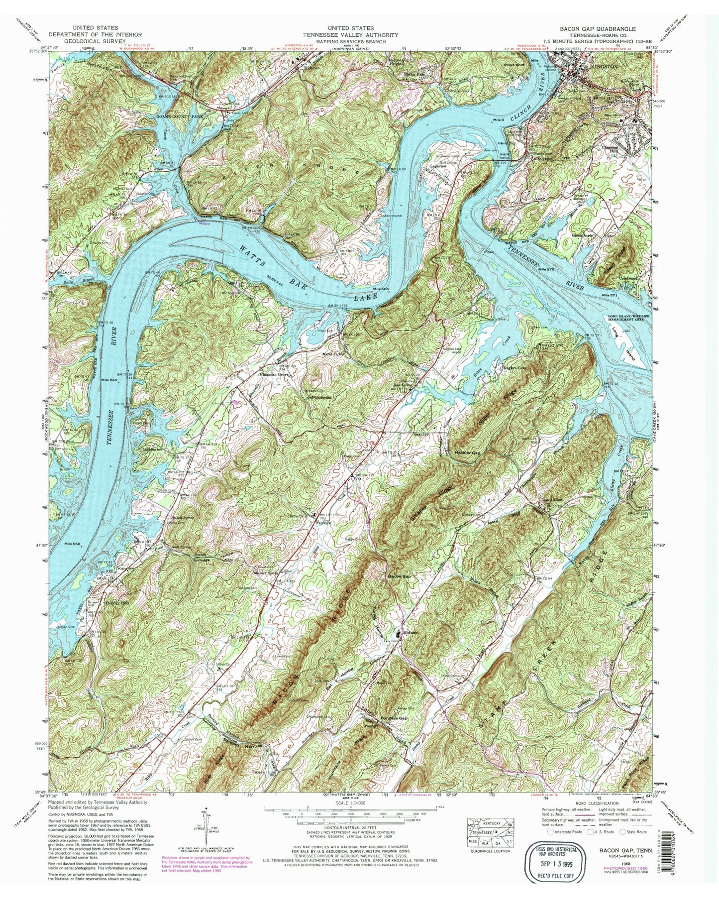
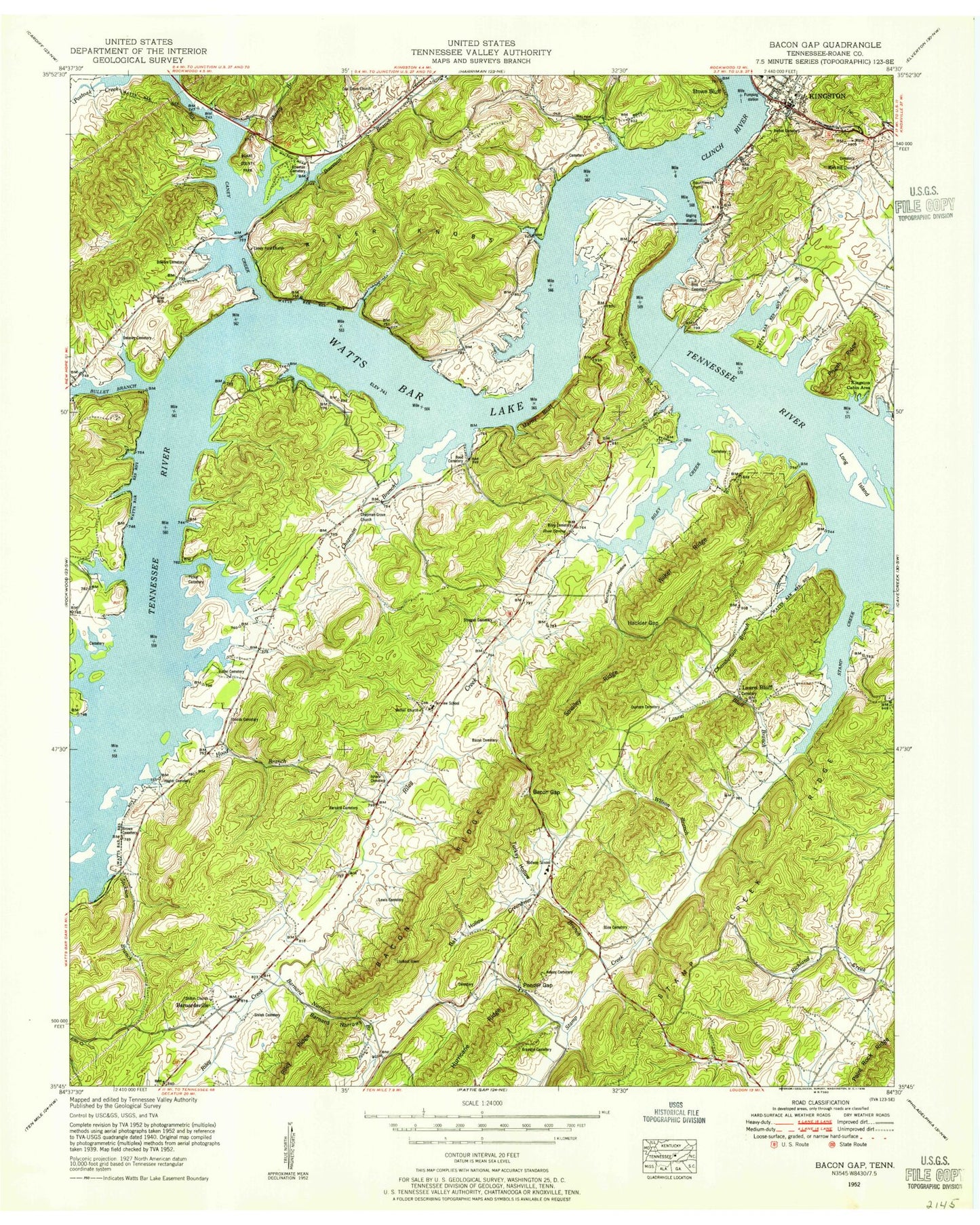
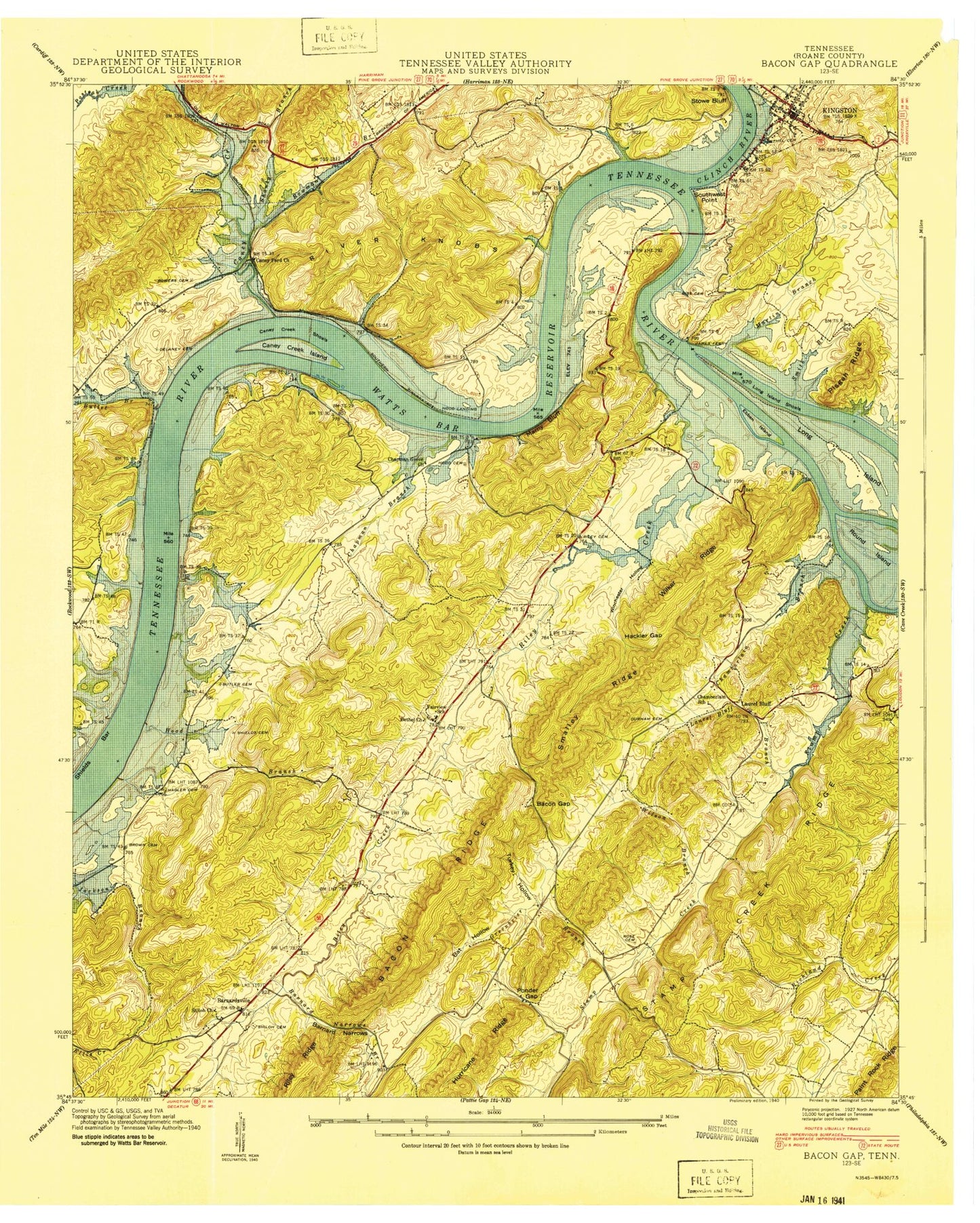
MyTopo
Classic USGS Bacon Gap Tennessee 7.5'x7.5' Topo Map
Couldn't load pickup availability
Historical USGS topographic quad map of Bacon Gap in the state of Tennessee. Map scale may vary for some years, but is generally around 1:24,000. Print size is approximately 24" x 27"
This quadrangle is in the following counties: Roane.
The map contains contour lines, roads, rivers, towns, and lakes. Printed on high-quality waterproof paper with UV fade-resistant inks, and shipped rolled.
Contains the following named places: Ambrose Spring, Anglers Cove, Bacon Cemetery, Bacon Gap, Bacon Ridge, Barnard Cemetery, Barnard Division, Barnard Narrows, Barnard Narrows Branch, Barnard Spring, Barnardsville, Bat Hollow, Bethel Cemetery, Bethel Church, BEthel United Presbyterian Church, Biss Cemetery, Bowers Cemetery, Bowman Branch, Bowman Cemetery, Brown Cemetery, Brown Ellis, Bullet Branch, Butler Cemetery, Caney Creek, Caney Creek Campground, Caney Creek Dock, Caney Creek Island, Caney Ford Church, Caney Fork Church, Caney Shoals, Center Cemetery, Chamberlain Branch, Chamberlin School, Chapman Branch, Chapman Grove, Chapman Grove Church, Cherokee Hills, Cherokee Middle School, Christopher Cemetery, Circle M, Claude Reed Dam, Claude Reed Lake, Clinch River, Commissioner District 7, Crestwood, Delaney Cemetery, Durham Cemetery, Ebben Island, Ellis Ferry, Ellis Ford, Fairview, Fairview Acres, Fairview School, Fort Southwest Point, Green Acres, Greenbrier Branch, Hackler Gap, Hagler Cemetery, Holiday Hills, Hood Branch, Hood Cemetery, Hood Landing, Hood Landing Ferry, Idle Oaks, Iron Divide, Isham Cemetery, Jackson Branch, Jackson Cemetery, James Ferry, Kelsay Cemetery, Kingston Church of Christ, Kingston Elementary School, Kingston Fire Station 1, Kingston First Baptist Church, Kingston United Methodist Church, Kingston Waterfront Park, Lacy Cemetery, Lake Shadow, Lakeharbor, Lakeview, Laurel Bluff, Laurel Bluff Baptist Church, Laurel Bluff Branch, Laurel Bluff Cemetery, Lewis Cemetery, Long Island, Long Island Wildlife Management Area, Margrave Valley, Marney Bluff, Mars Hill Church, Marsh Spring, Martin Branch, Martin Cemetery, Meadowlake Airport, Midtown Dock, Midway, Midway Church, Midway Elementary School, Midway High School, Montcrest, Morrison Hill Church, Oak Grove Church, Parker Cemetery, Pickel Cemetery, Picketts Landing, Pisgah Ridge, Ponder Church, Ponders, Ponders Branch, Ponders Gap, Richardsons Ferry, Riley Cemetery, Riley Creek, Riley Creek Recreational Area, River Knobs, Roane County, Roane County Park, Roane County Sheriff's Office, Rose Cemetery, Rose Spring, Round Island, Scott Spring, Sequoyah Shores, Shanty Branch, Shields Bar, Shields Cemetery, Shields Dam, Shields Spring, Shiloh Cemetery, Shiloh Church, Slave Cemetery, Smalley Ridge, South Roane County Volunteer Fire Department Station 1, South West Point, Southwest Point Golf Course, Southwest Point Park, Stamp Creek, Stamp Creek Ridge, Stamp Creek Valley, Stegall Cemetery, Stowe Station, Suburban Shores, Suck-egg Hollow, Turkey Hollow, Turner Bar, Twin Rivers Ferry, Watts Bar Lake, Wester Bluff, Westshore Estates, Wilker Ridge, Williams Cemetery, Wilson Branch, Winchester Hollow