MyTopo
Classic USGS Bar Harbor Maine 7.5'x7.5' Topo Map
Couldn't load pickup availability
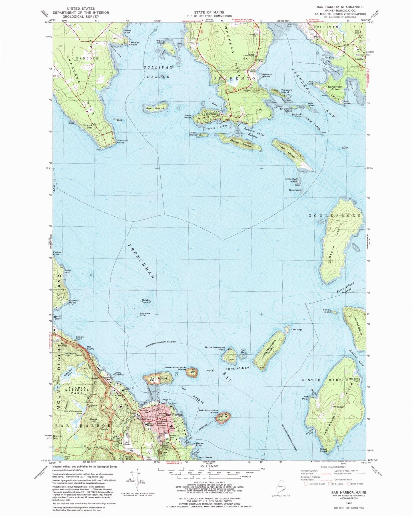
Historical USGS topographic quad map of Bar Harbor in the state of Maine. Typical map scale is 1:24,000, but may vary for certain years, if available. Print size: 24" x 27"
This quadrangle is in the following counties: Hancock.
The map contains contour lines, roads, rivers, towns, and lakes. Printed on high-quality waterproof paper with UV fade-resistant inks, and shipped rolled.
Contains the following named places: Ash Island, Ash Point, Back Cove, Bald Porcupine Island, Bald Rock, Bald Rock Ledge, Bar Harbor, Bar Harbor, Bar Harbor Ferry Terminal, Bar Harbor Yarmouth Nova Scotia Ferry, Bar Island, Bean Island, Bean Point, Brewer Mountain, Bunker Cove, Burnt Porcupine Island, Calf Island, Canoe Point, Compass Harbor, Crabtree Neck, Cromwell Brook, Cromwell Cove, Dorr Point, Dram Island, Eastern Point Harbor, Eddie Brook, Fish Point, Frenchman Bay, Grant Cove, Great Hill, Halftide Ledge, Halibut Hole, Hancock Point, Hancock Point, Hulls Cove, Ingalls Island, Ironbound Island, Jellison Cove, John Small Cove, Jordan Island, Cape Levi, Little Calf Island, Long Ledge, Long Porcupine Island, Lookout Point, McNeil Point, Morancy Stream, New Duck Brook, Ogden Point, Paradise Hill, Parker Point, Preble Island, Rum Key, Schieffelin Point, Seal Cove, Sheep Porcupine Island, Sheldrake Island, Sorrento, Sorrento Harbor, Southern Cove, Stave Island, Stave Island Harbor, Sullivan Harbor, The Bluffs, The Hop, Waukeag Neck, Witch Hole Pond, Yellow Island, The Porcupines, Hall Point, Duck Brook, Treasure Island, Flanders Bay, Sorrento School, Soward Island, Clam Ledge, Community Church, Bragdon - Hall Cemetery, Sorrento Community Church, Hall Cemetery, Great Head, Kebo Brook, Holy Redeemer Church, Saint Saviours Episcopal Church, Junk of Pork, Conners Emerson School, New Mills Meadow Pond, Emerson Junior High School, Thrumcap, Breaking Point, Charleys COve, Crabtree Ledge, Halftide Ledge, Porcupine Dry Ledge, Town of Sorrento, Eagle Lake Dam, Acadia National Park Visitors Center, Agamont Park, Bar Harbor Chamber of Commerce, Bar Harbor Congregational Church, Bar Harbor Fire Department, Bar Harbor Historical Society Building, Bar Harbor Historical Society Museum, Bar Harbor Post Office, Bar Harbor Shore Path, Bar Harbor Town Pier, Bar Harbor Whale Museum, Bar Island Trail, Bar Ledge, Beatrix Farrand Gardens, Beaver Ponds, Blair Dining Hall, Bogue Chitto (historical), Camp Community Lounge, College of the Atlantic Natural History Museum, Crabtree Ledge Light (historical), Criterion Theatre, Cromwell Harbor Ledge, Devils Half-Acre, Eno Greenhouse, First Baptist Church of Bar Harbor, Fishermans Landing, Goodwin Computer Laboratory, Grant Park, Hamors Wharf and Sawmill (historical), Harbor Place, High Street Health Center, Jessup Memorial Library, Jordan-Fernald Chapel, Kaelber Hall, Kebo Valley Golf Club, Saint Saviours Episcopal Parish Church Cemetery, Mount Desert Island Hospital, Mount Desert Reading Room (historical), Newlin Gardens, Oasis Club (historical), Point d'Acadie (historical), Ryles Building, Saint Silvias Roman Catholic Church, Science and Arts Building, Sea Urchin Building, Seafox, Snows Point, Sonogee Rehabilitation and Living Center, Sorrento Post Office, Sorrento Town Wharf, Southern Cove, Squaw Hollow (historical), Summit House Health Care Center, The Graveyard, The Shrine, College of the Atlantic Thorndike Library, Turretts Building, Uncle Steves Point, Village Green, West Coast Boat Yard, West Street Historic District, Witch Hole Pond Carriage Trail, YMCA Building, Bar Harbor Census Designated Place, Sorrento Fire Department, Bar Harbor Ambulance, Bar Harbor Police Department, Doanes Point Cemetery, Holy Redeemer Cemetery, Johnson Cemetery, Ledgelawn Cemetery, College of the Atlantic, Abbe Museum Research Library