MyTopo
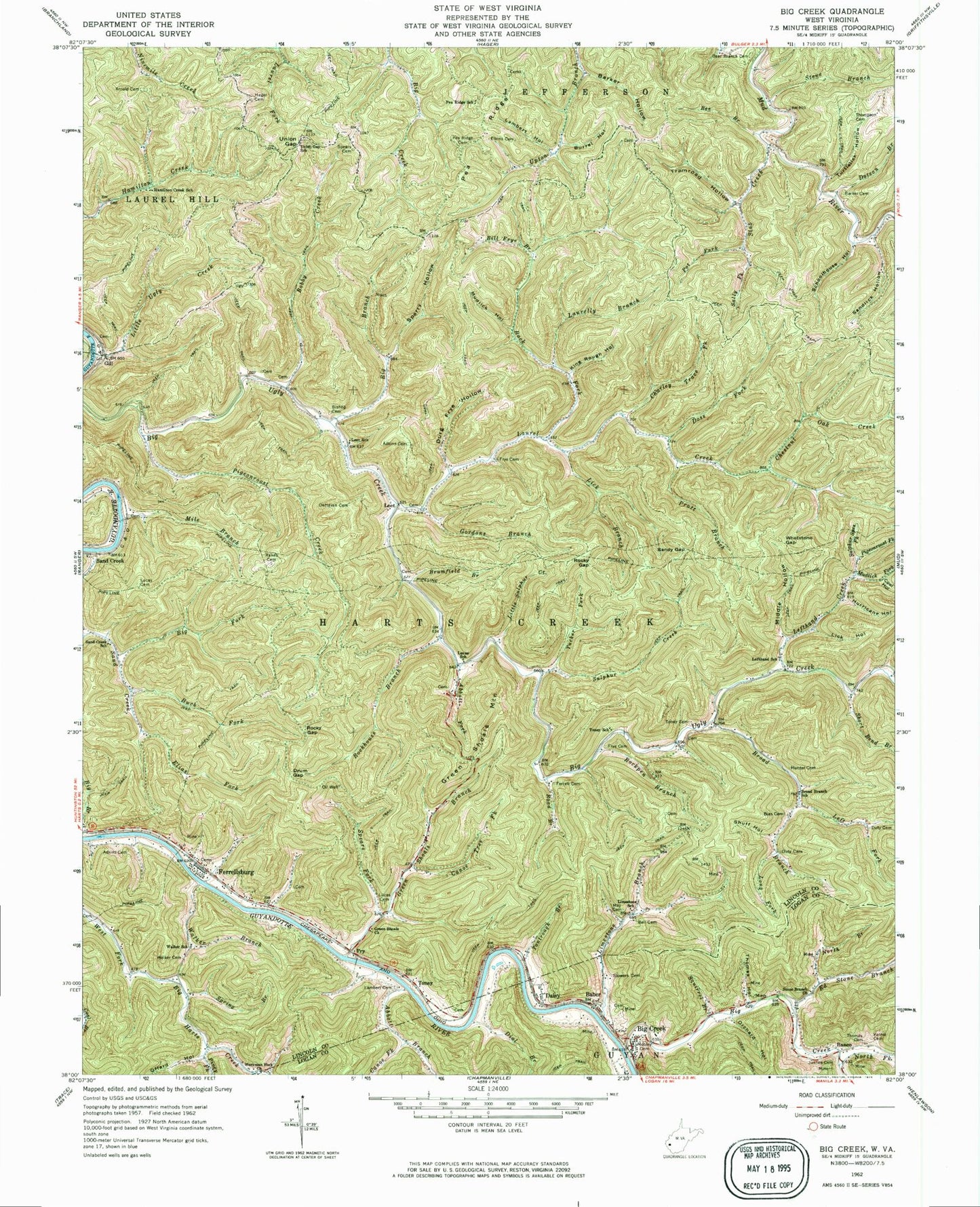
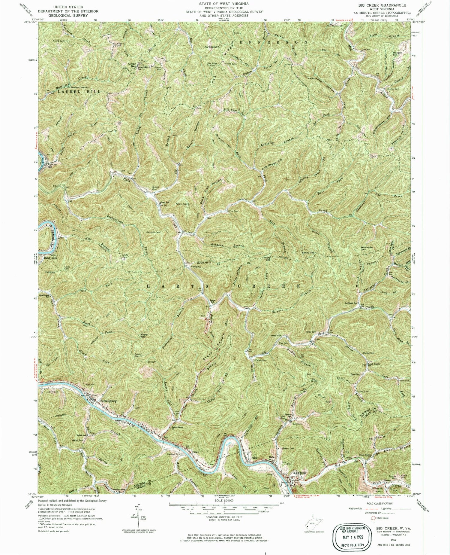
Classic USGS Big Creek West Virginia 7.5'x7.5' Topo Map
Couldn't load pickup availability
Historical USGS topographic quad map of Big Creek in the state of West Virginia. Map scale is 1:24000. Print size is approximately 24" x 27"
This quadrangle is in the following counties: Lincoln, Logan.
The map contains contour lines, roads, rivers, towns, and lakes. Printed on high-quality waterproof paper with UV fade-resistant inks, and shipped rolled.
Contains the following named places: Abbott Branch, Abbott Fork, Adkins Cemetery, Adkins Cemetery, Allen (historical), Arnold Cemetery, Baber, Back Fork, Banco, Barker Cemetery, Barker Hollow, Bear Branch Cemetery, Bee Branch, Bell Cemetery, Bias Cemetery, Big Branch, Big Creek, Big Creek, Big Creek Census Designated Place, Big Creek Post Office, Big Fork Sand Creek, Big Ugly Wildlife Management Area, Bill Frye Branch, Bishop Cemetery, Bobby Creek, Broad Branch, Broad Branch School (historical), Brumfield Branch, Buck Fork, Burrel Hollow, Canoe Fork, Canoe Tree Fork, Charley Trace Fork, Chestnut Oak Creek, Coal Hollow, Daisy, DeHaven Cemetery, Dial Branch, Doss Fork, Dotson Branch, Drum Gap, Durg Frye Hollow, Duty Cemetery, Duty Cemetery, Ed Stone Branch, Elias Fork, Elkins Cemetery, Ferrell Cemetery, Ferrellsburg, Ferrellsburg Cemetery, Ferrellsburg Elementary School (historical), Fry, Frye Cemetery, Frye Cemetery, Gill, Gordons Branch, Green Shoals Branch, Green Shoals Church, Green Shoals Mountain, Hager Cemetery, Hamilton Creek School (historical), Harts Creek District (historical), Hunter Cemetery, Hurricane Hollow, Justice Cemetery, King Rough Hollow, Lambert Cemetery, Lambert Hollow, Laurel Creek, Laurelly Branch, Leet, Leet School (historical), Left Fork Broad Branch, Lefthand Creek, Lefthand School (historical), Lick Branch, Lick Hollow, Limestone Branch, Limestone School (historical), Little Sulphur Creek, Little Sulphur Creek, Little Ugly Creek, Long Fork, Lucas Cemetery, Lucas Cemetery, Lucas School (historical), Marsh Fork, May Cemetery, Middle Hollow, Mile Branch, Mobley Cemetery, Mudlick Fork, Mudlick Hollow, North Branch Ed Stone Branch, North Fork Big Creek, Offard Hollow, Orchard Hollow, Pea Ridge, Pea Ridge Cemetery, Pea Ridge School (historical), Pigeonroost Creek, Pigeonroost Fork, Piney Fork, Pot Fork, Pratt Branch, Rakes Cemetery, Right Fork Laurel Creek, Road Branch, Rockhouse Branch, Rockpen Branch, Rocky Gap, Rocky Gap, Sally Fork, Sand Creek, Sand Creek, Sand Creek School (historical), Sandlick Hollow, Sandy Gap, Schoolhouse Hollow, Short Bend Branch, Shuff Hollow, Slab Creek, Spears (historical), Spears Cemetery, Spears Fork, Sperry Hollow, Spring Branch, Squirrel Branch, Steve Branch, Stone Branch Church, Stowers Cemetery, Sulphur Creek, Sulphur Springs Fork, Tantrough Branch, Thomas Cemetery, Thomas Hollow, Thompson Cemetery, Toney, Toney Cemetery, Toney School (historical), Tramrod Hollow, Tucker Fork, Turtlelick Hollow, Union Gap, Union Gap School (historical), Varnie Cemetery, Walker Branch, Walker Cemetery, Walker School (historical), Whetstone Gap, Workman Fork, Workman Fork Church