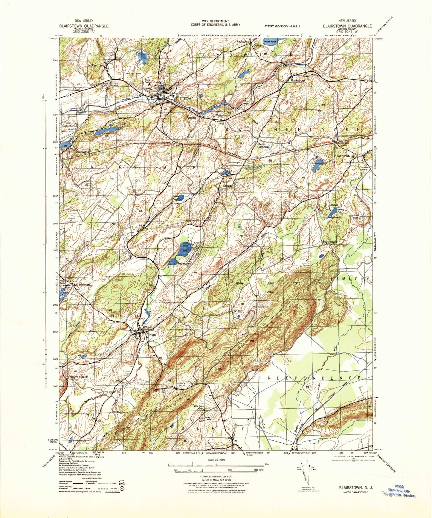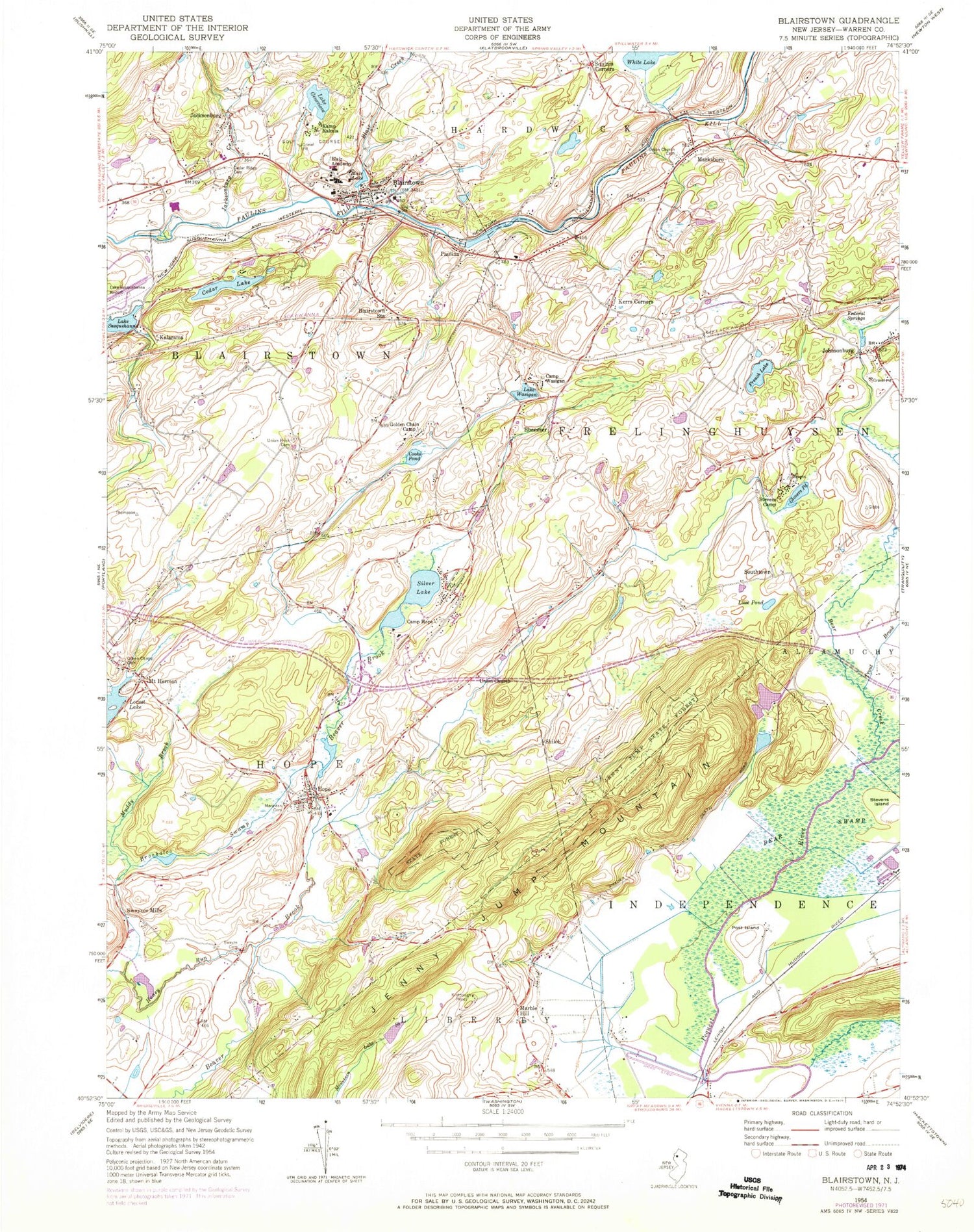

MyTopo
Classic USGS Blairstown New Jersey 7.5'x7.5' Topo Map
Couldn't load pickup availability
Historical USGS topographic quad map of Blairstown in the state of New Jersey. Map scale may vary for some years, but is generally around 1:24,000. Print size is approximately 24" x 27"
This quadrangle is in the following counties: Warren.
The map contains contour lines, roads, rivers, towns, and lakes. Printed on high-quality waterproof paper with UV fade-resistant inks, and shipped rolled.
Contains the following named places: Bear Brook, Bear Creek, Blair Academy, Blair Creek, Blair Lake, Blair Lake Dam, Blairstown, Blairstown Airport, Blairstown Ambulance Corps, Blairstown Census Designated Place, Blairstown Community Center, Blairstown Fire Department, Blairstown First Presbyterian Church, Blairstown Post Office, Blairstown Station, Blairstown Township Elementary School, Blairstown Township Municipal Building, Blairstown Township Police Department, Brookaloo Swamp, Camp Hope, Cedar Lake, Cedar Ridge Cemetery, Cooks Pond, Darst Heliport, Ebenezer, Evangelical Free Church, Febletown, Federal Springs, French Lake, French Lake Dam, Glovers Pond, Golden Chain Camp, Grace Community Church, Great Meadows Census Designated Place, Green Chapel Cemetery, Honey Run, Hope, Hope Census Designated Place, Hope Community Center, Hope Episcopal Church, Hope Lake, Hope Lake Dam, Hope Methodist Church, Hope Museum, Hope Post Office, Hope Township Elementary School, Hope Township Municipal Building, Hope Township Volunteer Fire Department, Independence Township Police Department, Island Dragway Volunteer Rescue Squad, Jacksonburg, Jacksonburg Creek, Jenny Jump Mountain, Jenny Jump State Forest, Johnsonburg, Johnsonburg Census Designated Place, Johnsonburg Post Office, Kalarama, Kamp Kalmia, Kerrs Corners, Kishpaugh Mines, Lake Genevieve, Lake Kalmia Dam, Lake Susquehanna, Lake Wasigan, Little Hill Alina Lodge, Longmeadow Farm, Luse Pond, Lutheran Church of the Good Shepard, Marble Hill, Marksboro, Marksboro Census Designated Place, Marksboro Community Presbyterian Church, McDonoughs Heliport, Moravian Cemetery, Moravian Grange Hall Number 187, Mount Hermon, Mount Hermon Census Designated Place, Mount Hermon United Methodist Church, Muddy Brook, New Jersey State Police Troop B Hope Station, North Warren Regional High School, Paulina, Paulina Lake, Paulina Lake Dam, Post Island, Shiloh, Silver Lake Census Designated Place, Southtown, Squires Corners, Stevens Camp, Stevens Island, Swayze Cemetery, Swayzes Mills, Township of Blairstown, Township of Frelinghuysen, Township of Hope, Township of Independence, Trout Brook, Union Brick Cemetery, Union Church, Union Church Cemetery, United Astronomy Clubs of New Jersey Observatory, United Methodist Church of Johnsonburg, Warren County Public Library, Wasigan Camp, White Lake, Willowcreek Farms, ZIP Codes: 07825, 07838, 07846