MyTopo
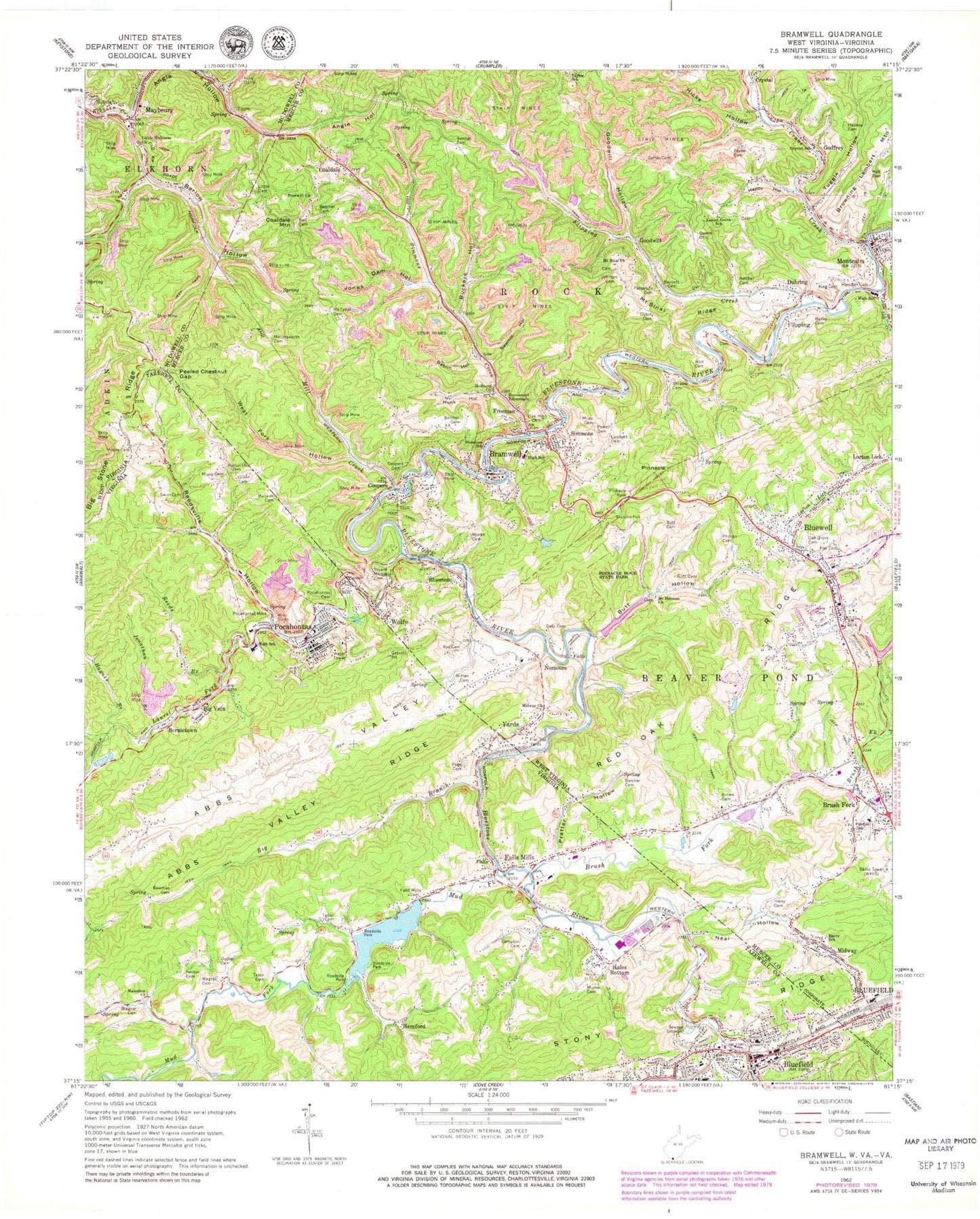
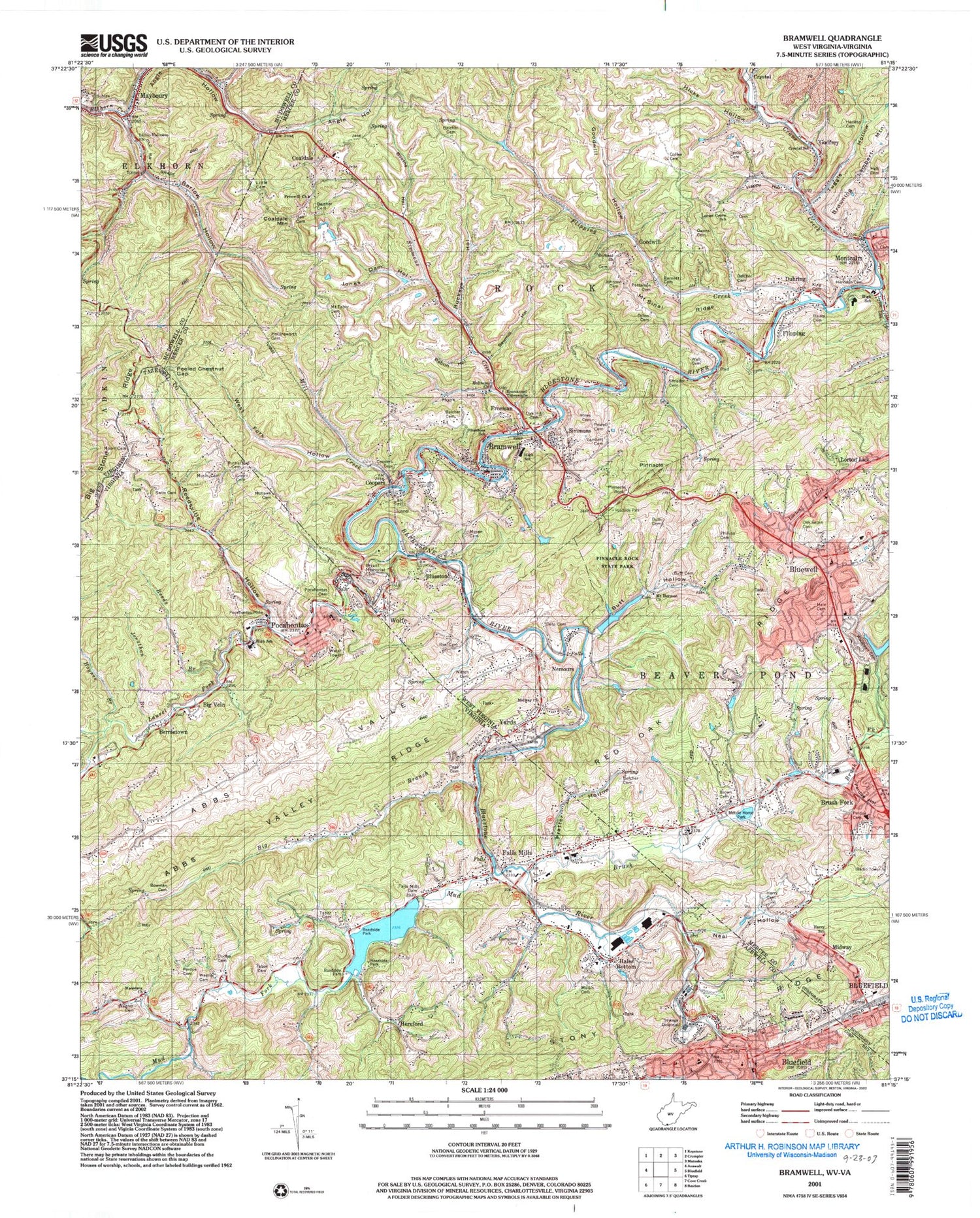
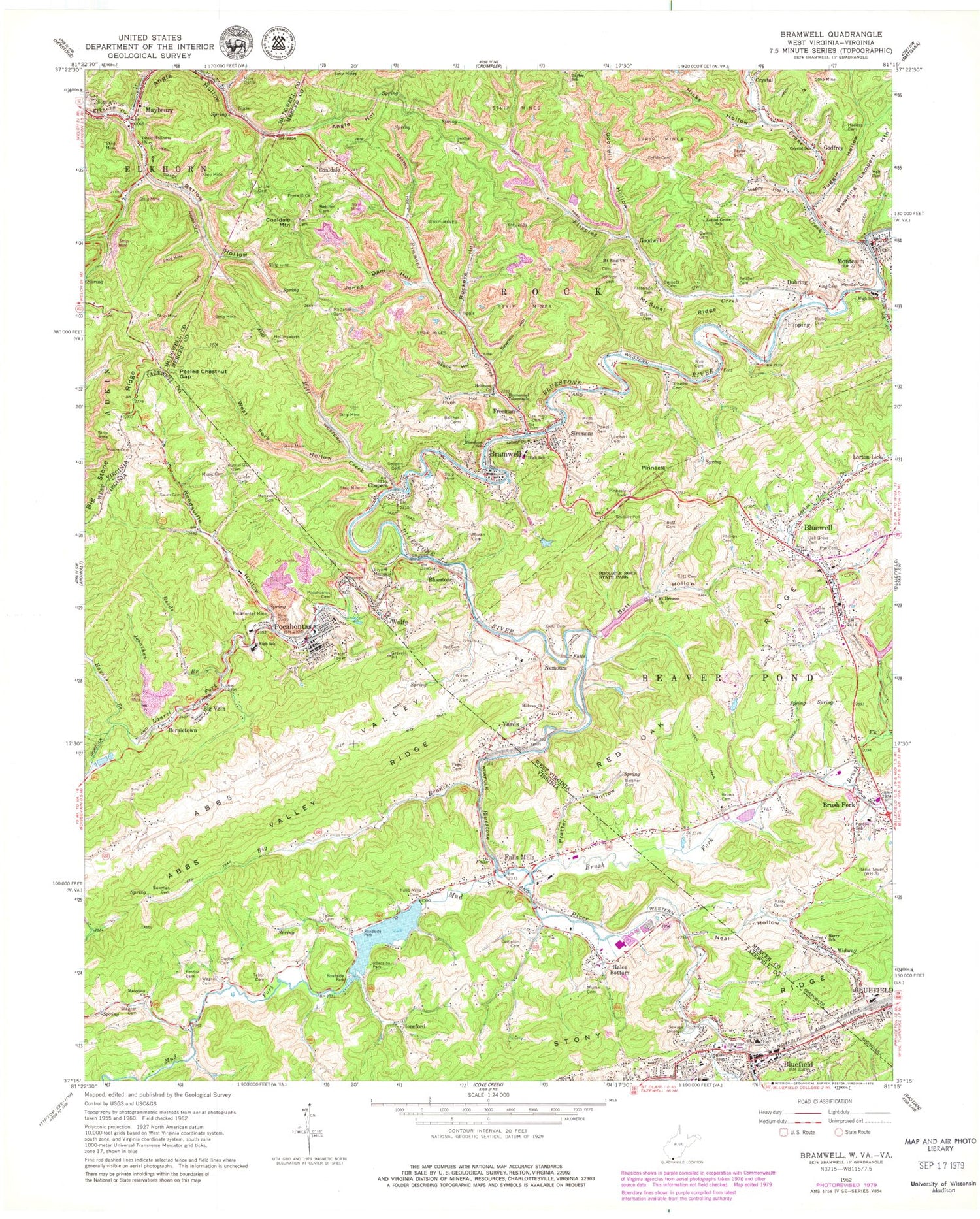
Classic USGS Bramwell West Virginia 7.5'x7.5' Topo Map
Couldn't load pickup availability
Historical USGS topographic quad map of Bramwell in the states of West Virginia, Virginia. Typical map scale is 1:24,000, but may vary for certain years, if available. Print size: 24" x 27"
This quadrangle is in the following counties: McDowell, Mercer, Tazewell.
The map contains contour lines, roads, rivers, towns, and lakes. Printed on high-quality waterproof paper with UV fade-resistant inks, and shipped rolled.
Contains the following named places: Mohawk Cemetery, Yards, Abbs Valley, Bablin Hollow, Bailey Cemetery, Barlow Hollow, Barnett Cemetery, Belcher Branch, Belcher Cemetery, Belcher Cemetery, Belcher Cemetery, Belcher Cemetery, Bell Cemetery, Bluestone School (historical), Booths Hollow, Bramwell, Brown Cemetery, Bryant Memorial Cemetery, Buckeye Hollow, Butt Cemetery, Butt Cemetery, Butt Hollow, Coffee Cemetery, Coopers, Coopers Cemetery, Crane Creek, Crystal School (historical), Delp Cemetery, Dillon Cemetery, Duhring, Emmanuel Tabernacle, Flat Top Yards, Flipping Creek, Freewill Church, Goodwill Hollow, Hale Cemetery, Hall Cemetery, Happy Hollow, Harless Cemetery, Harry Cemetery, Harry School (historical), Herndon Cemetery, Hicks Hollow, Holiness Church, Hollinsworth Cemetery, Hunk Hollow, Johnson Cemetery, Jones Dam Hollow, King Cemetery, Lambert Cemetery, Little Cemetery, Little Fork, Little Holiness Church, Locust Grove School (historical), Midway Church, Miles Cemetery, Mill Creek, Mohawk Cemetery, Mount Hermon Church, Mount Sinai Church, Mount Sinai Ridge, Mount Tabor Cemetery, Oak Grove Cemetery, Oak Hill Cemetery, Owens Cemetery, Patterson Cemetery, Perdue Cemetery, Phillips Cemetery, Pinnacle, Pinnacle Rock, Pinnacle Rock State Park, Poe Cemetery, Powell Cemetery, Rye Cemetery, Sawmill Hollow, Shrader Cemetery, Simmons Creek, Taylor Cemetery, Tuggle Hollow, Wall Cemetery, West Fork Hollow, Witten Cemetery, Woodlawn Cemetery, Lorton Lick Creek, Montcalm, Perdue Hollow, Bluestone, Bluewell, Brush Fork, Coaldale, Coaldale Mountain, Flipping, Freeman, Godfrey, Goodwill, Maybeury, Midway, Nemours, Simmons, Wolfe, Bluewell Elementary School, Bramwell Elementary School (historical), Bramwell High School (historical), Bramell Historic District, Brushfork Elementary School, Butt School (historical), Church of Christ, Jims Branch, Lick Branch, Lower Georges Branch, Montcalm High School, Mount Herman Cemetery, Nemours School (historical), Nemours Station (historical), Ruth (historical), Brushfork Church of God, New Bramwell Water Supply Dam, Bramwell Lake, Bluewell Dam Number One, Pinnacle Rock Lake Dam, Pinnacle Rock Lake Number One, Old Bramwell Water Supply Dam, Bramwell Post Office, Coaldale Post Office, Duhring Post Office, Montcalm Post Office, Nemours Post Office, WHIS-AM (Bluefield), Abbs Valley (historical), Little Fork, Shinbrier, Blue Hole, Isaac Bell Cemetery, Harris Grocery (historical), Shinbrier - Coopers School (historical), Isaac Bell Log Home, Montcalm Census Designated Place, Town of Bramwell, Bluewell Volunteer Fire Department, Bramwell Volunteer Fire Department, Montcalm Volunteer Fire Department, Bluewell Census Designated Place, Maybeury Census Designated Place, Crystal, Bramwell Police Department, Maybeury Post Office, Big Branch, Bowman Cemetery, Brush Fork, Compton Cemetery, Dudley Cemetery, Falls Mills Dam, Green Cemetery, Haynes Branch, Jonathan Branch, Macedona Church, Mullin Cemetery, Music Cemetery, Neal Hollow, Page Cemetery, Peeled Chestnut Gap, Perdus Cemetery, Pocahontas Cemetery, Pocahontas Mine, Pratter Hollow, Reeds Branch, Swim Cemetery, Tabor Cemetery, Tabor Cemetery, Wagner Cemetery, Wagner Cemetery, Beaverpond Creek, Bluefield, Laurel Fork, Mud Fork, Bernietown, Big Vein, Falls Mills, Hales Bottom, Hereford, Pocahontas, Bethel United Methodist Church, Bluefield Post Office, Church of God, Coal Run, Falls Mills Elementary School, Falls Mills Lake, First Methodist Church, Graham Christian Church, Graham Intermediate School, Graham Presbyterian Church, Holiness Gospel Tabernacle, Logan Street School, Memorial Baptist Church, Pocahontas High School, Pocahontas Historic District, Saint Marys Episcopal Church, Tabernacle Baptist Church, Tazewell County High School (historical), Virginia School (historical), WBDY-AM (Bluefield), Rutherford Cemetery, Bluefield Virginia Fire Department, Abbs Valley - Boissevain - Pocahontas Rescue Squad, Bluefield Virginia Rescue Squad, Pocahontas Volunteer Fire Company, Town of Pocahontas, National College, Pocahontas State Correctional Center, Falls Mills Post Office, Pocahontas Post Office, Pochahontas Police Department, Falls Mills Census Designated Place