

MyTopo
Classic USGS Chester Massachusetts 7.5'x7.5' Topo Map
Couldn't load pickup availability
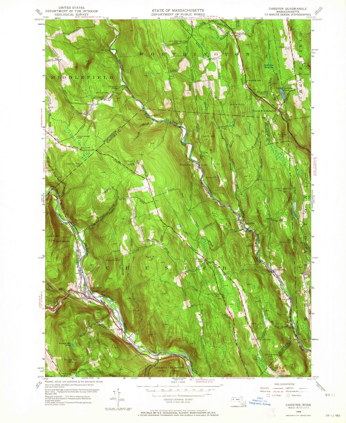
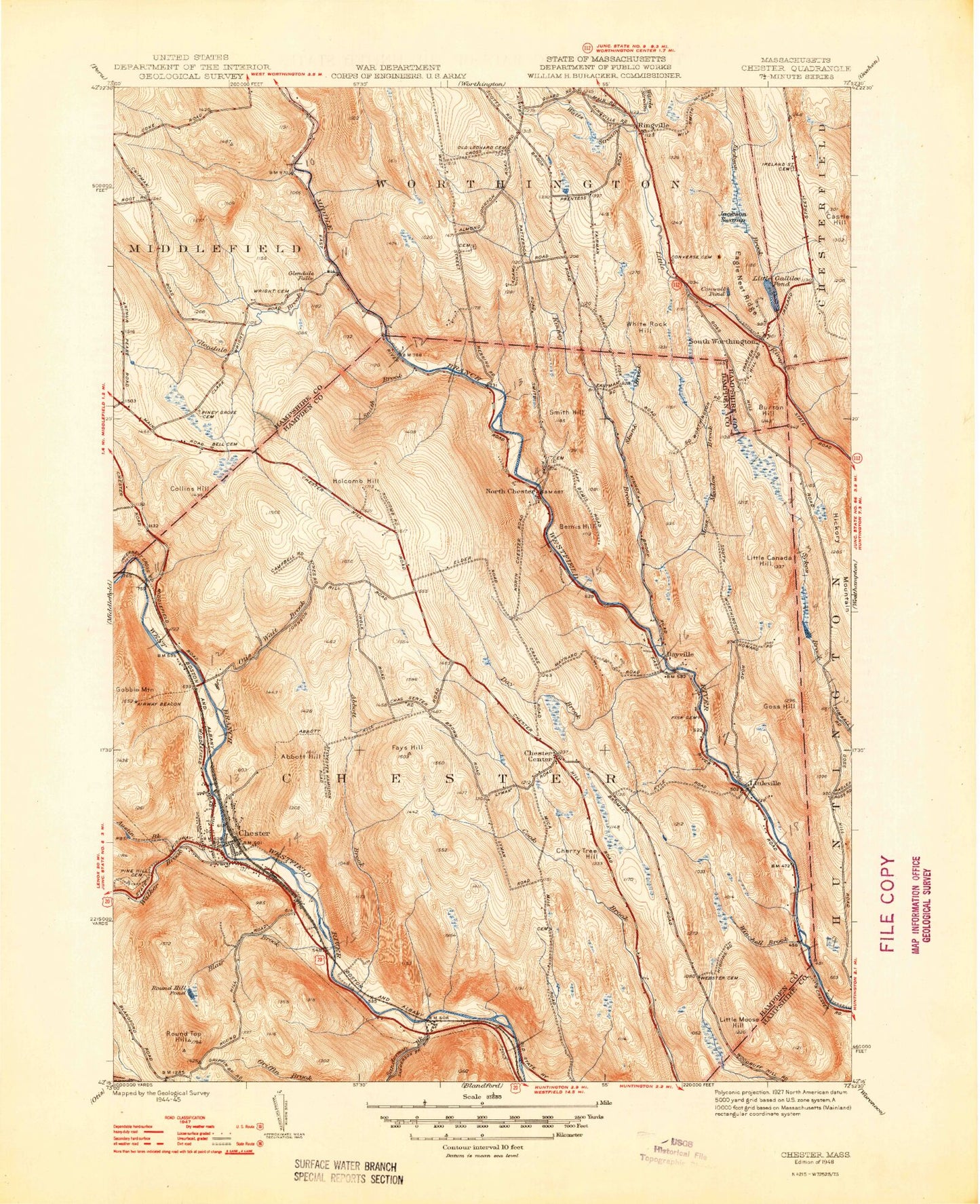
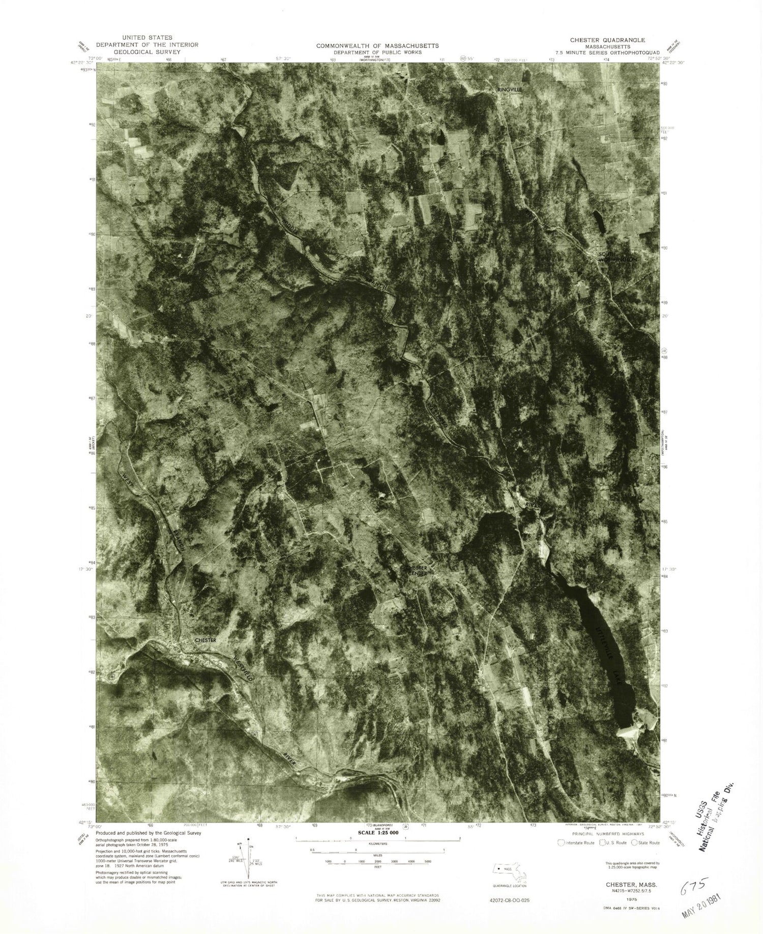
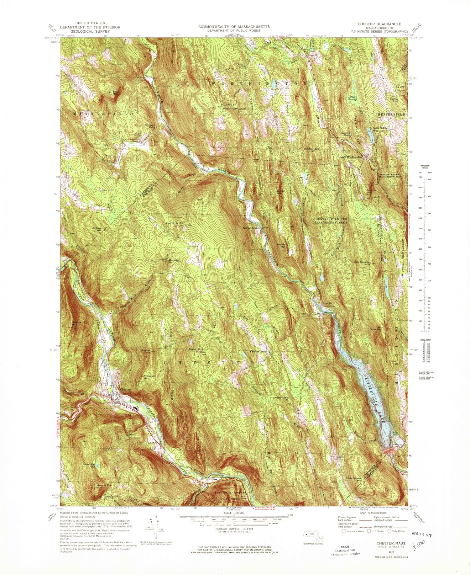
Historical USGS topographic quad map of Chester in the state of Massachusetts. Typical map scale is 1:24,000, but may vary for certain years, if available. Print size: 24" x 27"
This quadrangle is in the following counties: Hampden, Hampshire.
The map contains contour lines, roads, rivers, towns, and lakes. Printed on high-quality waterproof paper with UV fade-resistant inks, and shipped rolled.
Contains the following named places: Old Leonard Cemetery, Converse Cemetery, Wright Cemetery, Pine Grove Cemetery, Bell Cemetery, Littleville Dam, Webster Cemetery, Pine Hill Cemetery, Chester Wildlife Management Area, Ireland Street Cemetery, Abbott Brook, Abbott Hill, Austin Brook, Bemis Hill, Blair Brook, Burton Hill, Castle Hill, Cherry Tree Hill, Chester, Chester Center, Collins Hill, Conwell Pond, Day Brook, Dayville, Eagle Nest Ridge, Eastmans Brook, Fays Hill, Glendale Brook, Glendale Falls, Gobble Mountain, Goss Hill, Hickory Mountain, Holcomb Hill, Jackson Brook, Jackson Swamp, Kinne Brook, Little Canada Hill, Little Gallilee Pond, Little Moose Hill, Littleville, Moss Meadow Brook, North Chester, Otis Wait Brook, Ringville, Round Hill Pond, Round Top Hill, Sanderson Brook, Skunk Brook, Smith Brook, Smith Hill, South Worthington, Still Brook, Walker Brook, Wards Stream, Watts Stream, Winchell Brook, White Rock Hill, Littleville Lake, Town of Chester, Chester Center Historic District, Chester Elementary School, Chester Factory Village Historic District, Chester Post Office, Chester Town Hall, Ireland Street Orchard, Chester Census Designated Place, Chester Fire Department Station 1 Headquarters, Chester Fire Department Station 2, Chester Police Department, Westfield Wild and Scenic River, Old Leonard Cemetery, Converse Cemetery, Wright Cemetery, Pine Grove Cemetery, Bell Cemetery, Littleville Dam, Webster Cemetery, Pine Hill Cemetery, Chester Wildlife Management Area, Ireland Street Cemetery, Abbott Brook, Abbott Hill, Austin Brook, Bemis Hill, Blair Brook, Burton Hill, Castle Hill, Cherry Tree Hill, Chester, Chester Center, Collins Hill, Conwell Pond, Day Brook, Dayville, Eagle Nest Ridge, Eastmans Brook, Fays Hill, Glendale Brook, Glendale Falls, Gobble Mountain, Goss Hill, Hickory Mountain, Holcomb Hill, Jackson Brook, Jackson Swamp, Kinne Brook, Little Canada Hill, Little Gallilee Pond, Little Moose Hill, Littleville, Moss Meadow Brook, North Chester, Otis Wait Brook, Ringville, Round Hill Pond, Round Top Hill, Sanderson Brook, Skunk Brook, Smith Brook, Smith Hill, South Worthington, Still Brook, Walker Brook, Wards Stream, Watts Stream, Winchell Brook, White Rock Hill, Littleville Lake, Town of Chester, Chester Center Historic District, Chester Elementary School, Chester Factory Village Historic District, Chester Post Office, Chester Town Hall, Ireland Street Orchard, Chester Census Designated Place, Chester Fire Department Station 1 Headquarters, Chester Fire Department Station 2, Chester Police Department, Westfield Wild and Scenic River, Old Leonard Cemetery, Converse Cemetery, Wright Cemetery, Pine Grove Cemetery, Bell Cemetery, Littleville Dam, Webster Cemetery, Pine Hill Cemetery, Chester Wildlife Management Area, Ireland Street Cemetery, Abbott Brook, Abbott Hill, Austin Brook, Bemis Hill, Blair Brook, Burton Hill, Castle Hill, Cherry Tree Hill, Chester, Chester Center, Collins Hill, Conwell Pond, Day Brook, Dayville, Eagle Nest Ridge, Eastmans Brook, Fays Hill, Glendale Brook, Glendale Falls, Gobble Mountain, Goss Hill, Hickory Mountain, Holcomb Hill, Jackson Brook, Jackson Swamp, Kinne Brook, Little Canada Hill, Little Gallilee Pond, Little Moose Hill, Littleville, Moss Meadow Brook, North Chester, Otis Wait Brook, Ringville, Round Hill Pond, Round Top Hill, Sanderson Brook, Skunk Brook, Smith Brook, Smith Hill, South Worthington, Still Brook, Walker Brook, Wards Stream, Watts Stream, Winchell Brook, White Rock Hill, Littleville Lake, Town of Chester, Chester Center Historic District, Chester Elementary School, Chester Factory Village Historic District, Chester Post Office, Chester Town Hall, Ireland Street Orchard, Chester Census Designated Place, Chester Fire Department Station 1 Headquarters, Chester Fire Department Station 2, Chester Police Department, Westfield Wild and Scenic River