MyTopo
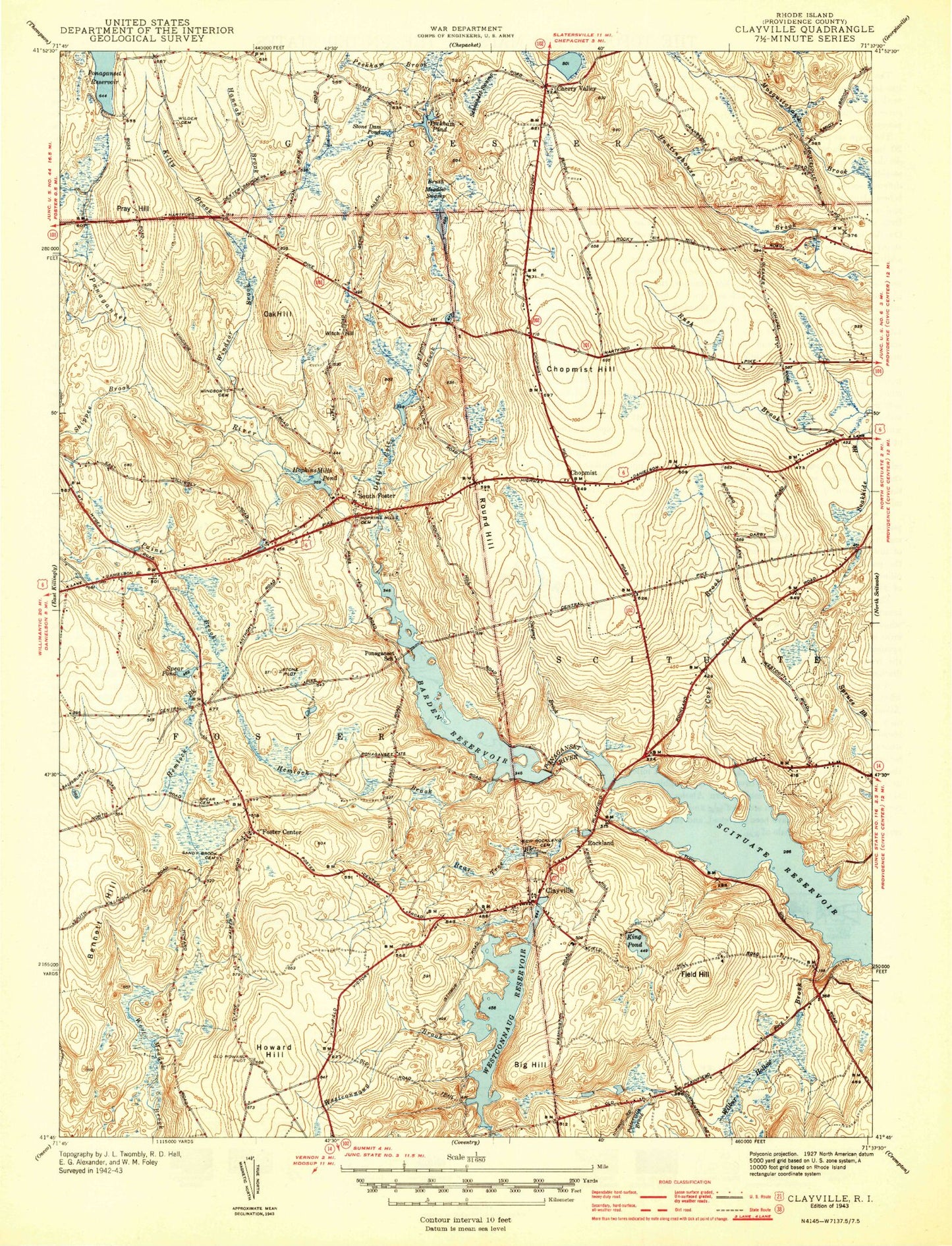
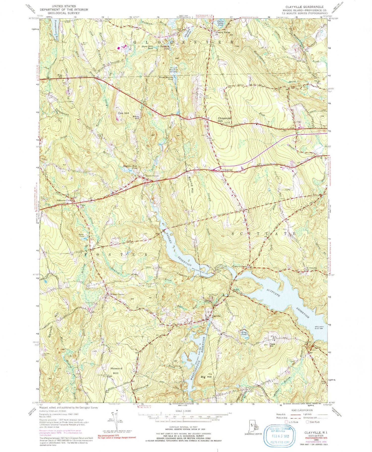
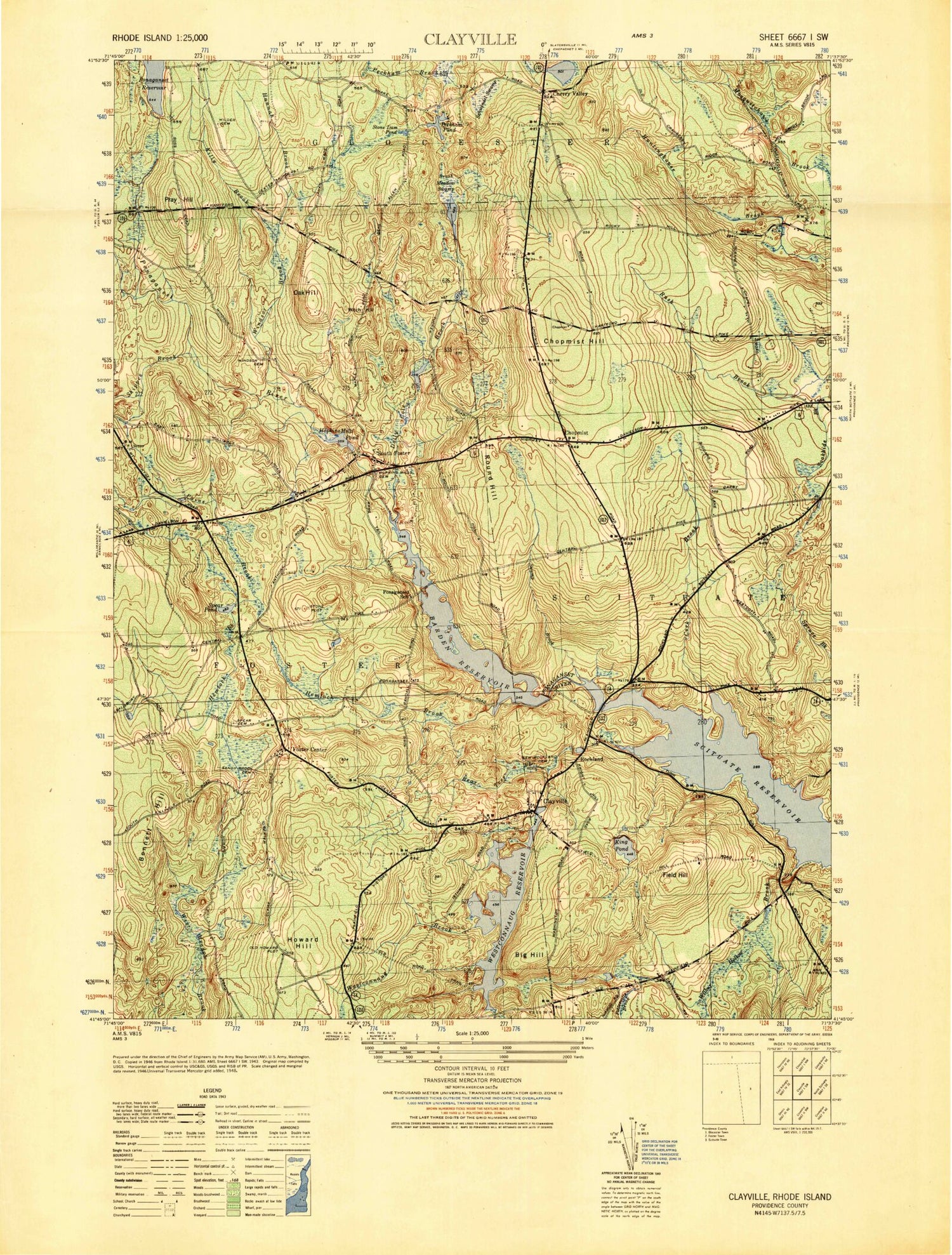
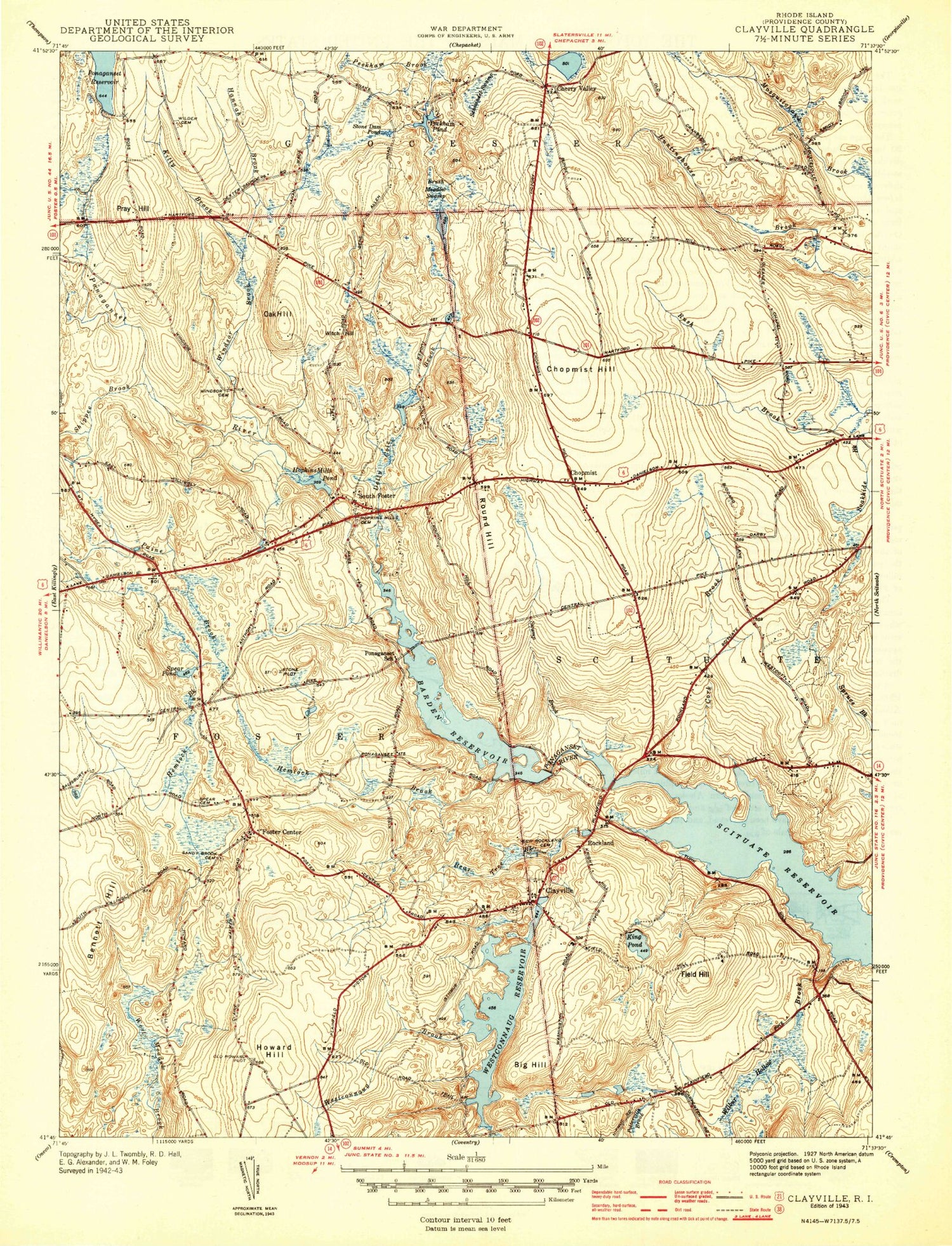
Classic USGS Clayville Rhode Island 7.5'x7.5' Topo Map
Couldn't load pickup availability
Historical USGS topographic quad map of Clayville in the states of Rhode Island, Massachusetts. Typical map scale is 1:24,000, but may vary for certain years, if available. Print size: 24" x 27"
This quadrangle is in the following counties: Providence.
The map contains contour lines, roads, rivers, towns, and lakes. Printed on high-quality waterproof paper with UV fade-resistant inks, and shipped rolled.
Contains the following named places: Howard Hill, Big Hill, Potterville Brook, Field Hill, Wilbur Hollow Brook, Bear Tree Brook, Clayville, Hemlock Brook, Foster Center, Bennett Hill, Spear Pond, Paine Brook, Barden Reservoir, Ponaganset River, Crazy Corners, Cork Brook, Round Hill, Dolly Cole Brook, South Foster, Hopkins Mills Pond, Shippee Brook, Oak Hill, Witch Hill, Chopmist Hill, Killy Brook, Cherry Valley Pond, Schwindel Swamp, Peckham Pond, Peckham Brook, Stone Dam Pond, Allan Richard Brook, Hannah Brook, Pray Hill, King Pond, Swamp Brook, Winsor Brook, Westconnaug Reservoir, Westconnaug Reservoir Dam, Barden Reservoir Dam, Keech Pond, Keech Pond Dam, Hopkins Mill Pond Dam, Ponaganset Reservoir Dam, Cherry Valley Pond Dam, Hopkins Mills, Rockland (historical), Brush Meadow Swamp, Simmons Corner, Cherry Valley, Ponaganset (historical), Westconnaug Brook, Chopmist, Town of Foster, Captain Isaac Paine School, Chopmist Fire Lookout Station, Clayville Church, Clayville Elementary School, Clayville Historic District, Foster Center Historic District, Foster Post Office, Foster Town Hall, Hopkins Mill Historic District, Hopkins Mills Lot Cemetery, New Rockland Cemetery, Daniel Howard Lot, Charles Phillips Lot Cemetery, Phillips Memorial Cemetery, Ponaganset High School, Ponaganset Middle School, Ponagansett Bridge, Ponagansett Public Fishing Area, Saint Timothy Church, Sand Hill Cemetery, Colonel Nathaniel Stone Lot Cemetery, Swamp Meadow Covered Bridge, Chopmist Hill Fire Department, Foster Center Fire Department, Foster Police Department, Foster Public Library, Potterville Fire Department, Scituate Early Learning Center, South Volunteer Foster Fire Company, West Glocester Fire Department Station 2, Clayville Post Office, Sunset Orchards, Clayville Census Designated Place, Foster Center Census Designated Place, Scituate Ambulance and Rescue Corps, Foster Ambulance Corps, Spears Lot, Hopkins - Potter Lot, Stephen Williams Lot Cemetery, Morning Star Church Cemetery, Aseph Saunders Lot, Horace Cole Lot, Keech - Windsor Lot, Hopkins - Tucker Lot, Constant Round Lot Cemetery, Nathaniel Phillips Cemetery, Clayville Cemetery, Cole and Philips Lot, William Sanders Lot Cemetery, Colonel William Davis Lot, Captain Isaac Hopkins Lot, Benjamin - Bennett Lot, Colonel Israel Phillips Lot, Hopkins Lot, George Bennett Lot, Samuel Tillinghast Lot, Colonel James Whipple Lot, Jonathan Perkins Lot, Angell - Eddy Lot, Samuel McGee Lot, William Wood Lot Cemetery, Thomas Hill Lot, Walker - Randall Lot, Jonathan Pray Lot, Paris Simmons Lot, Asaph Wilder Burial Ground, Gardiner Buffington Lot, John Gross Junior Lot, Colonel Henry Wheeler Lot, Westcott - Wilkinson Lot, Roger W Tourtelett Lot Cemetery, Captain Dean Kimball Lot, Aldrich Wilmarth Lot, Angell - Cornell Lot, Nicholas Thomas Lot, Christopher Fenner Lot Cemetery, Yeaw - Howard - Philips Lot, Josiah Westcott Lot, Knight Hill Road Lot, Darius Durfee Lot, Samuel Fenner Lot, Christopher Smith Lot, Benjamin Angell Lot Cemetery, Jeremiah Brown Lot, Town Asylum Lot, Thomas Weaver Lot, Burton Potter Lot, Moses Potter Lot, Horton - Hathaway Lot, Isaac Field Lot, Colonel Stephen Young Lot, Benedict Whipple Lot, Thomas Lawton Lot, Thomas H Devaul Lot Cemetery, Barden Cemetery, Abraham Corp Lot Cemetery, Cyriel Simmons Lot, West Lot, Dexter Arnold Lot, Rhode Island Historic Cemetery Foster 105, Mill Pond Dam, Howard Hill, Big Hill, Potterville Brook, Field Hill, Wilbur Hollow Brook, Bear Tree Brook, Clayville, Hemlock Brook, Foster Center, Bennett Hill, Spear Pond, Paine Brook, Barden Reservoir, Ponaganset River, Crazy Corners, Cork Brook, Round Hill, Dolly Cole Brook, South Foster, Hopkins Mills Pond, Shippee Brook, Oak Hill, Witch Hill, Chopmist Hill, Killy Brook, Cherry Valley Pond, Schwindel Swamp, Peckham Pond, Peckham Brook, Stone Dam Pond, Allan Richard Brook, Hannah Brook, Pray Hill, King Pond, Swamp Brook, Winsor Brook, Westconnaug Reservoir, Westconnaug Reservoir Dam, Barden Reservoir Dam, Keech Pond, Keech Pond Dam, Hopkins Mill Pond Dam, Ponaganset Reservoir Dam, Cherry Valley Pond Dam, Hopkins Mills, Rockland (historical), Brush Meadow Swamp, Simmons Corner, Cherry Valley, Ponaganset (historical), Westconnaug Brook, Chopmist, Town of Foster, Captain Isaac Paine School, Chopmist Fire Lookout Station, Clayville Church, Clayville Elementary School, Clayville Historic District, Foster Center Historic District, Foster Post Office, Foster Town Hall, Hopkins Mill Historic District, Hopkins Mills Lot Cemetery, New Rockland Cemetery, Daniel Howard Lot, Charles Phillips Lot Cemetery, Phillips Memorial Cemetery, Ponaganset High School, Ponaganset Middle School, Ponagansett Bridge, Ponagansett Public Fishing Area, Saint Timothy Church, Sand Hill Cemetery, Colonel Nathaniel Stone Lot Cemetery, Swamp Meadow Covered Bridge, Chopmist Hill Fire Department, Foster Center Fire Department, Foster Police Department, Foster Public Library, Potterville Fire Department, Scituate Early Learning Center, South Volunteer Foster Fire Company