MyTopo
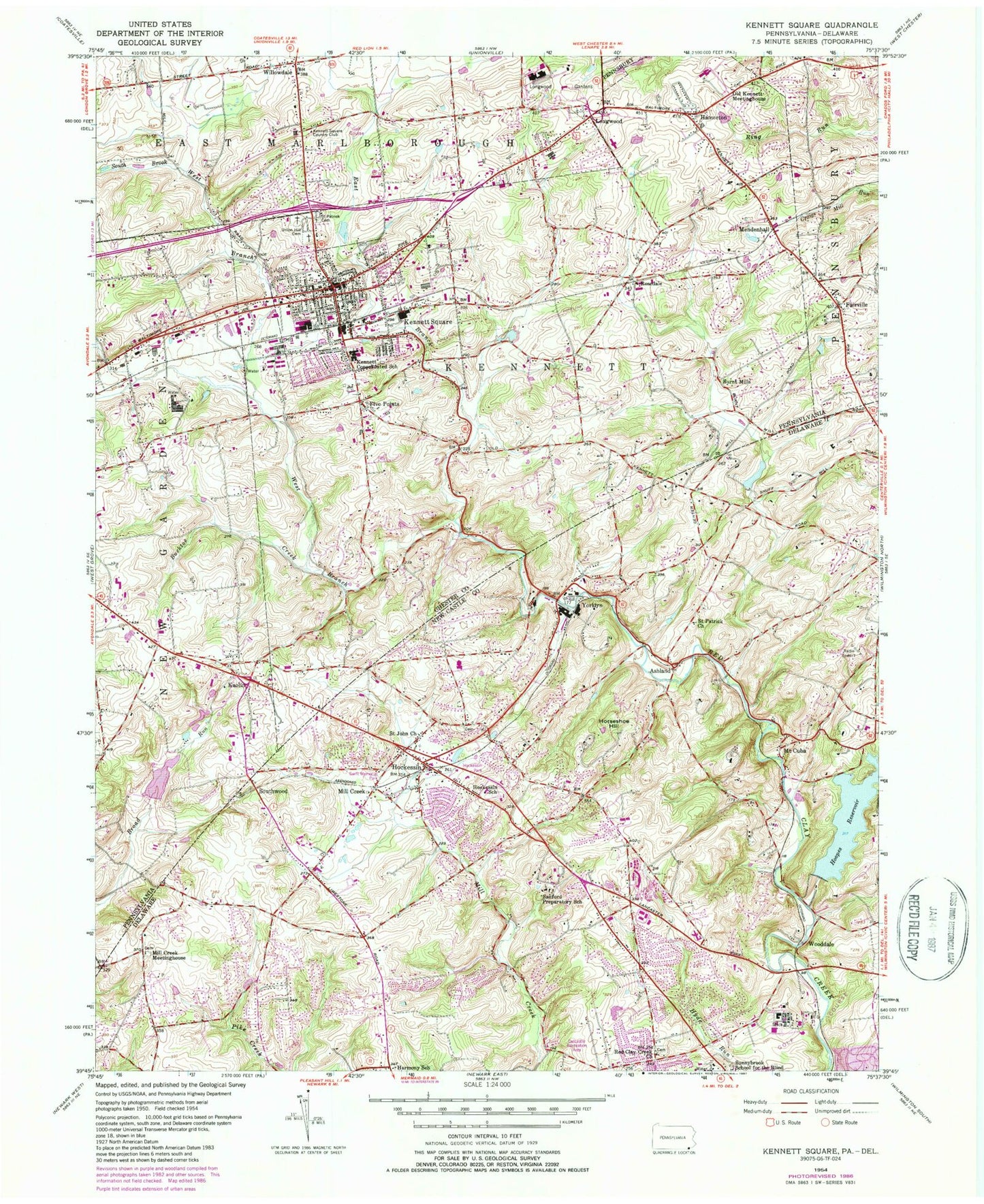
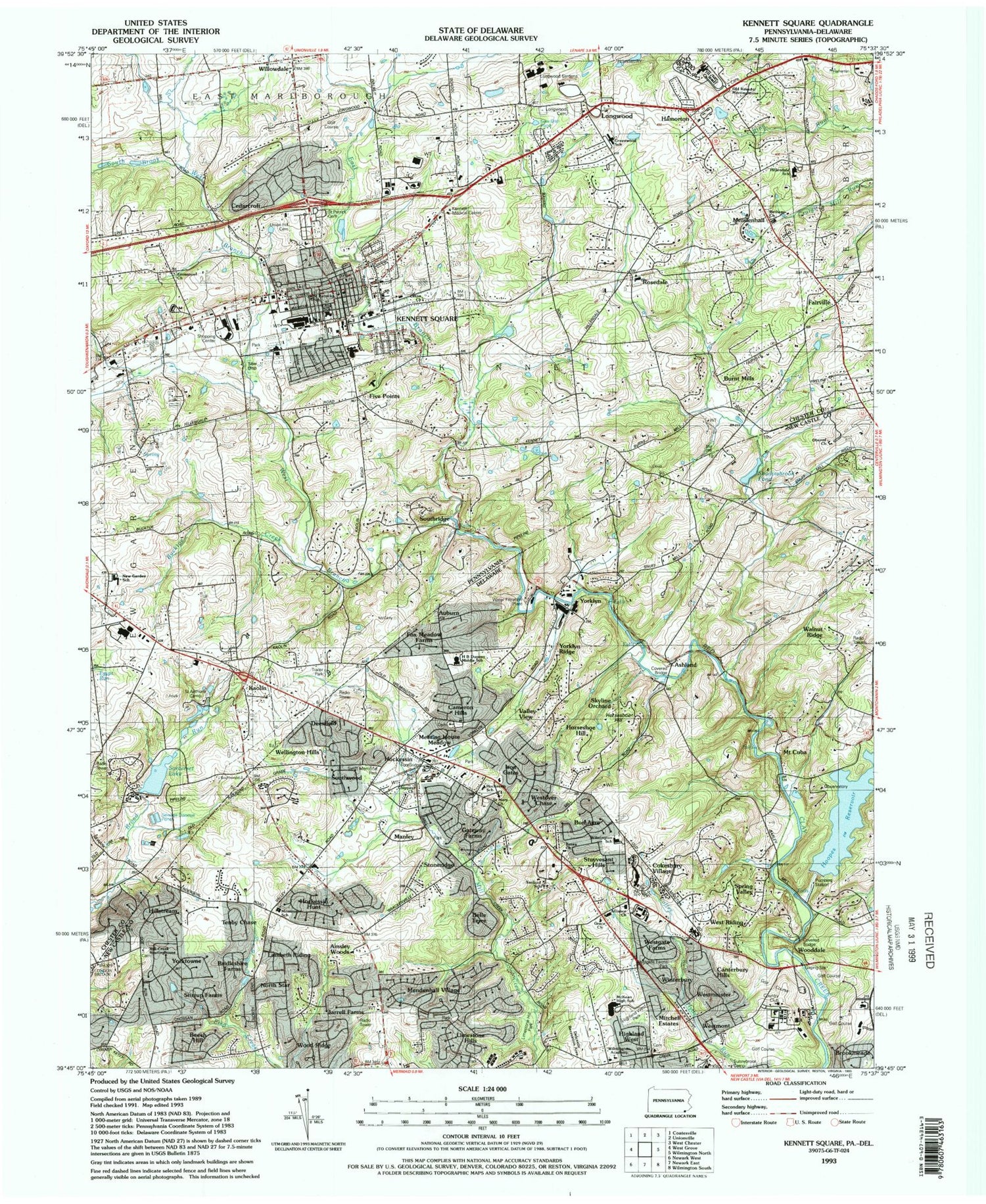
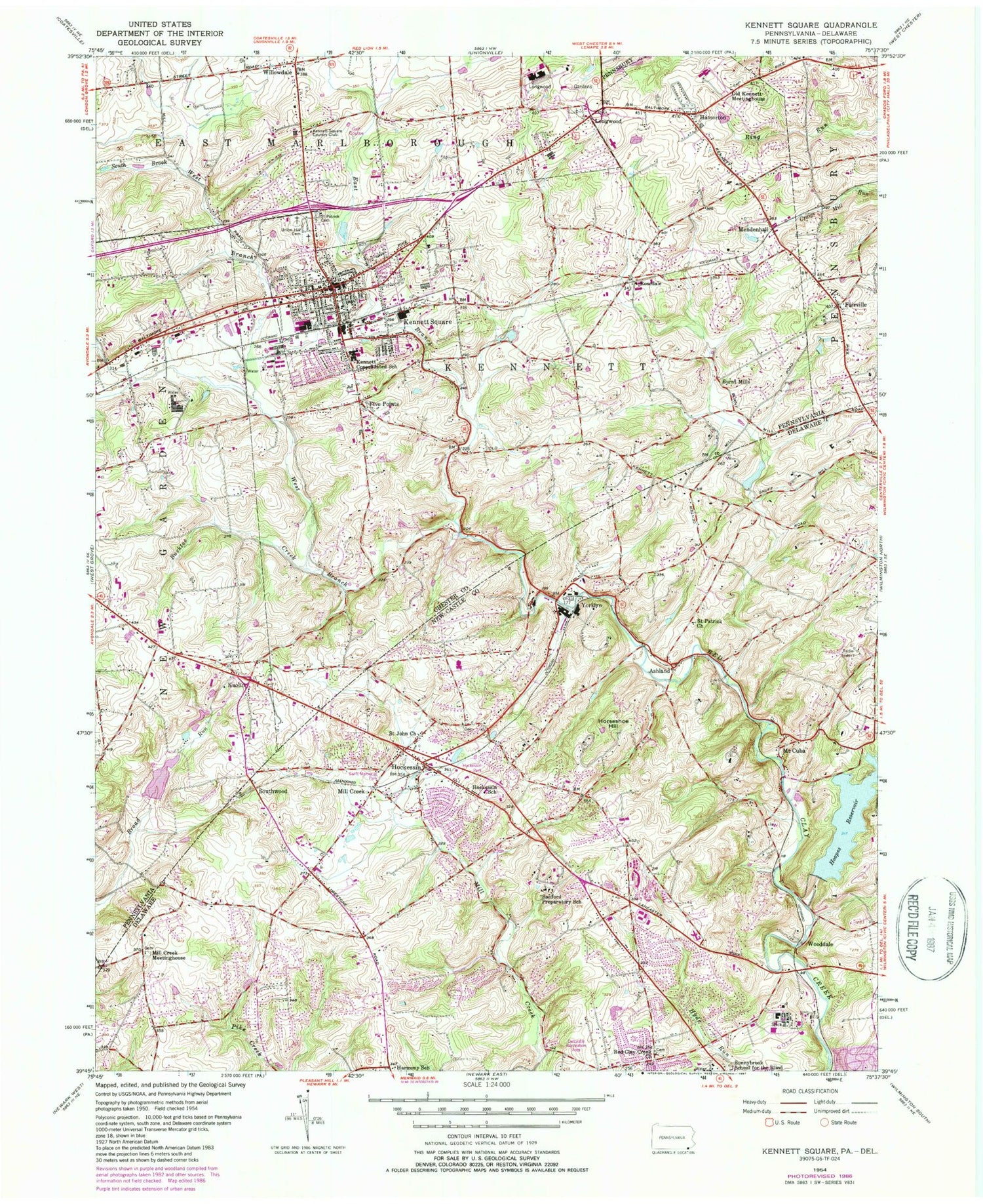
Classic USGS Kennett Square Pennsylvania 7.5'x7.5' Topo Map
Couldn't load pickup availability
Historical USGS topographic quad map of Kennett Square in the states of Pennsylvania, Delaware. Typical map scale is 1:24,000, but may vary for certain years, if available. Print size: 24" x 27"
This quadrangle is in the following counties: Chester, New Castle.
The map contains contour lines, roads, rivers, towns, and lakes. Printed on high-quality waterproof paper with UV fade-resistant inks, and shipped rolled.
Contains the following named places: Bucktoe Creek, East Branch Red Clay Creek, Fairville, Kennett Consolidated School, Kennett Square, Longwood Gardens, Old Kennett Meetinghouse, Saint Patrick Cemetery, Union Hill Cemetery, West Branch Red Clay Creek, Willowdale, Whittle Airport (historical), Burnt Mills, Five Points, Hamorton, Kaolin, Longwood, Mendenhall, Rosedale, Greenwood Elementary School, Mary D Lang Elementary School, Kennett Middle School, New Garden Elementary School, Dupont Dam, Lower Dam, South Brook, Full Gospel Apostolic Church, China Temple Church, Kennett Square Missionary Baptist Church, New Garden Memorial United American Methodist Episcopal Church, Highway Tabernacle Fire Baptized Holiness Church, Longwood Cemetery, Bethel American Methodist Episcopal Church, Kennett Friends Meetinghouse, Episcopal Church of the Advent, Willowdale Chapel, Emmanuel Temple Church, Kennett Square Mennonite Church, Bible Methodist Church, First Baptist Church, Saint Patricks School, Kennett Square Presbyterian Church, Westminster House of the Presbyterian Church of Kennett Square, Somerset Dam, Somerset Lake, Mendenhall Station, Kennett Square Reservoir, Kennett Square Country Club, Borough of Kennett Square, Township of Kennett, Quartz Creek, Chadds Ford West, American Christmas Museum, Lancashire Elementary School, Pennsbury Township Building, Agnew Run, Richards Run, Walton Run, Woodcock Rill, Scarlett Run, Tannery Run, Kennett Fire Company 1 Station 24, Longwood Fire Company Station 25, Kennett Square Police Department, Kennett Township Police Department, Kennett Square Post Office, Mendenhall Post Office, Kennett Friends Burial Ground, Bucktoe Cemetery, Hamorton Census Designated Place, Bissell Sanitorium, Hockessin, Hockessin School, Hoopes Reservoir, Horseshoe Hill, Mill Creek Meetinghouse, Mount Cuba, Red Clay Creek Presbyterian Church, Saint John Church (historical), Saint Patrick Church (historical), Sanford School, Sunnybrook School for the Blind, H B Dupont Middle School, Hockessin Montessori School, Parish of the Resurrection, Chippey Chapel Church, WZZE-FM (Hockessin), WAMS-AM (Wilmington), Coffee Run, Brookmeade, Pentland, Auburn, Valley View, Yorklyn Ridge, Larchmont, Snug Hill, Skyline Orchard, Horseshoe Hill, Montgomery Woods, Iron Gates, Walnut Hill, Cameron Hills, Heatherton, Meeting House Meadows, Hockessin Park, Berkeley Ridge, Charter Oaks, Manley, Stoneridge, Windward, West Riding, Cokesbury Village, Tree Top Valley, Stuyvesant Hills, Mitchell Estates, Highland West, Quail Ridge, Mockingbird Hill, Rolling Ridge, Bella Vista, Hickory Ridge, Limestone Hills, Mendenhall Village, Vintage Village, Jarrell Farms, Ainsley Woods, North Star Addition, Lambeth Riding, Beech Hill, Tenby Chase, York Towne, Hillstream, Little Baltimore, Lamatan I, Lamatan II, Owls Nest, Cricket Hill, Wood Ridge, Bridleshire Farms, Ashland, Mill Creek, Southwood, Wooddale, Yorklyn, Hercules Country Club, Limestone Hills Park, Swift Memorial Park, Shadowbrook Dam, Shadowbrook Pond, Edgar M Hoopes Dam, Westminster, Brackenville, Loveville, Westgate Farms, Canterbury Hills, Oakwood Hills, Winterbury, North Star, Meadowbrook, Mill Creek Hundred, Meeting House Hill, Cornish Hills, Haverford, Hickory Hill, White Briar, Highland Meadows, Brackenville Woods, Burrows Run, Walnut Ridge, Trepagnier, Swallow Hill, Church Hill, Spring Valley, Heather Valley, Mockingbird Hills, Runnymeade, Gateway Farms, Brookhill Farms, Holly Knoll, Wellington Hills, Quaker Hill, Auburn Hills, Harmony School (historical), Fox Meadow, Hockessin Friends School, Hockessin Friends Meetinghouse, Hockessin United Methodist Church, Hockessin United Methodist School, Oberod Episcopal Diocese of Delaware, Hockessin Baptist Church, Hockessin Baptist School, Saint Mary of the Assumption Church, Berea Presbyterian Church, Wilmington Christian School, Thomas KcKean High School, Highland West Park, Stirrup Farms, Berkeley Farms, Piedmont Division, Hockessin Hunt, McKean High School, Wilmington Academy, Westgate Farms Park, Westmont, Bon Ayre, Hockessin Post Office, Hockessin Public Library, Grace Lutheran Church, First Alliance Church, Pathways Community Church, North Star Census Designated Place, Hockessin Census Designated Place, Hockessin Fire Company, Yorklyn Post Office