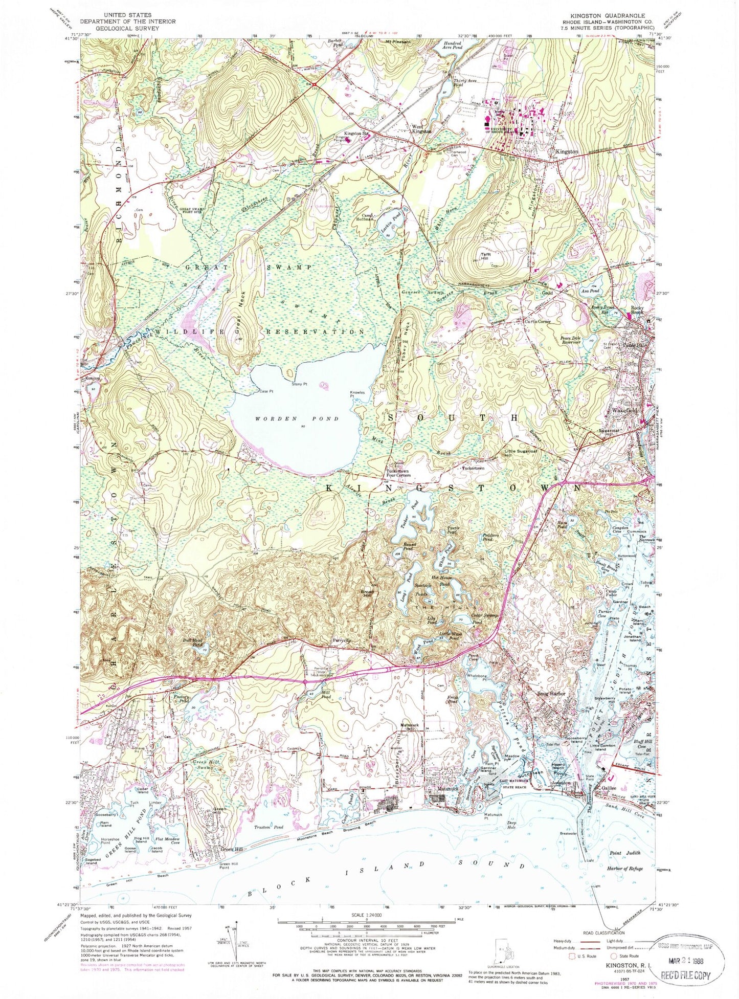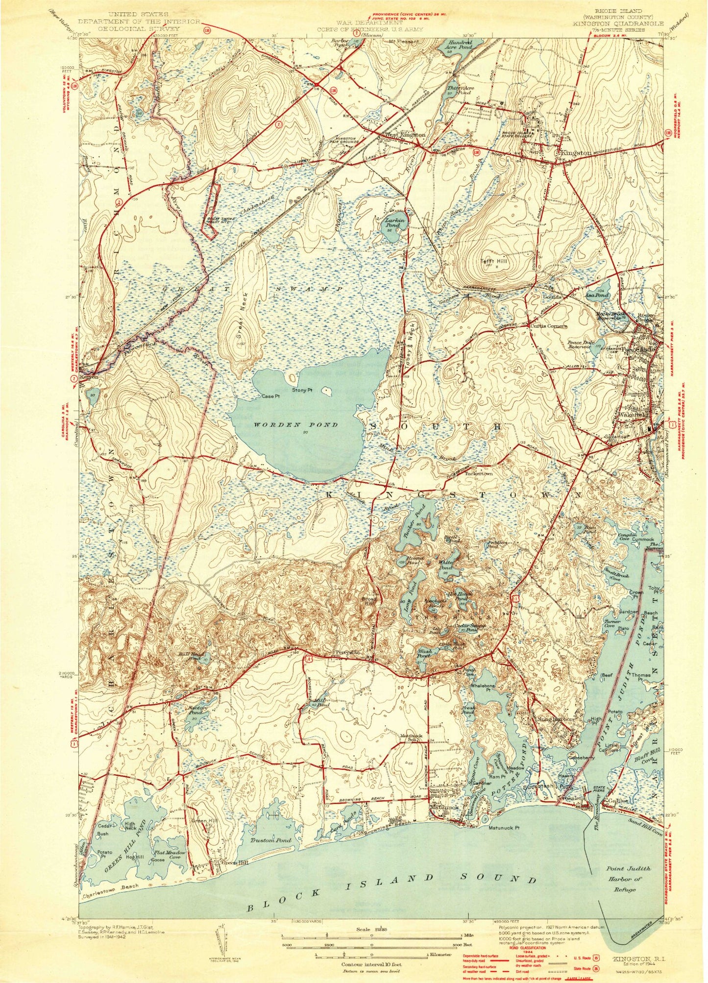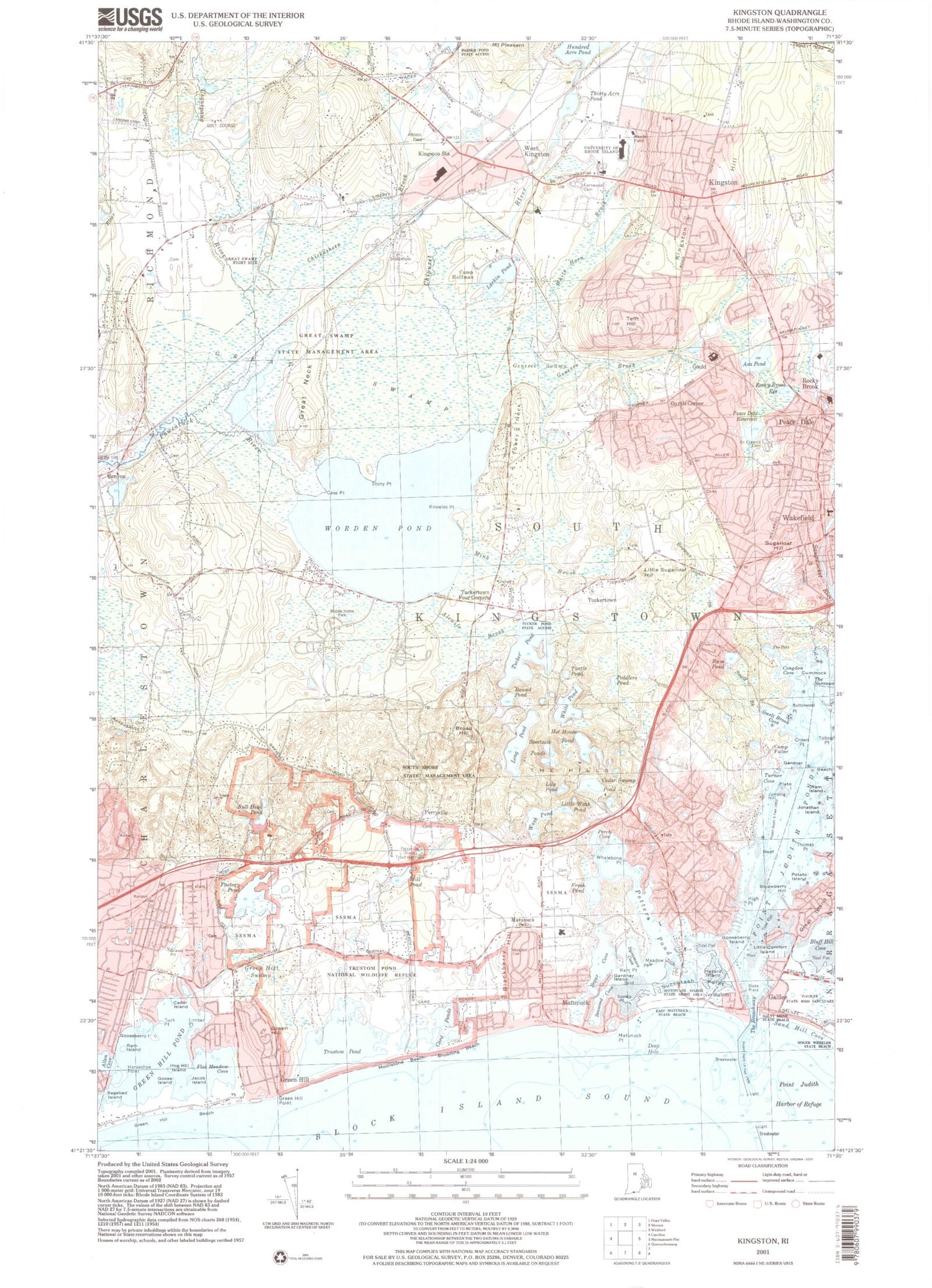
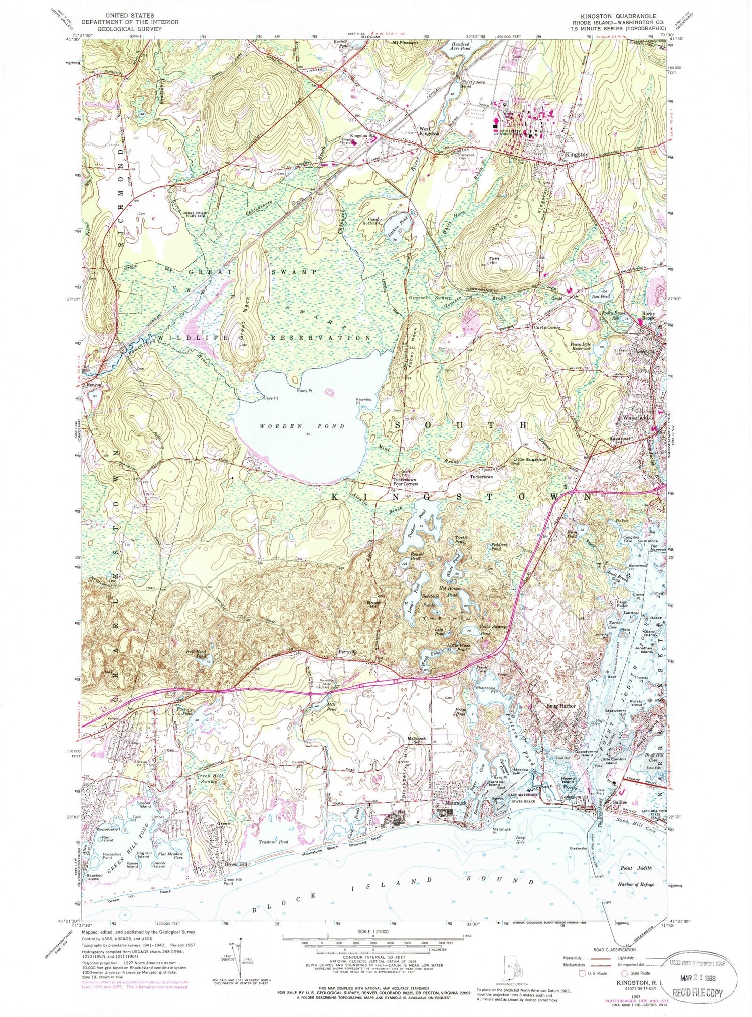

MyTopo
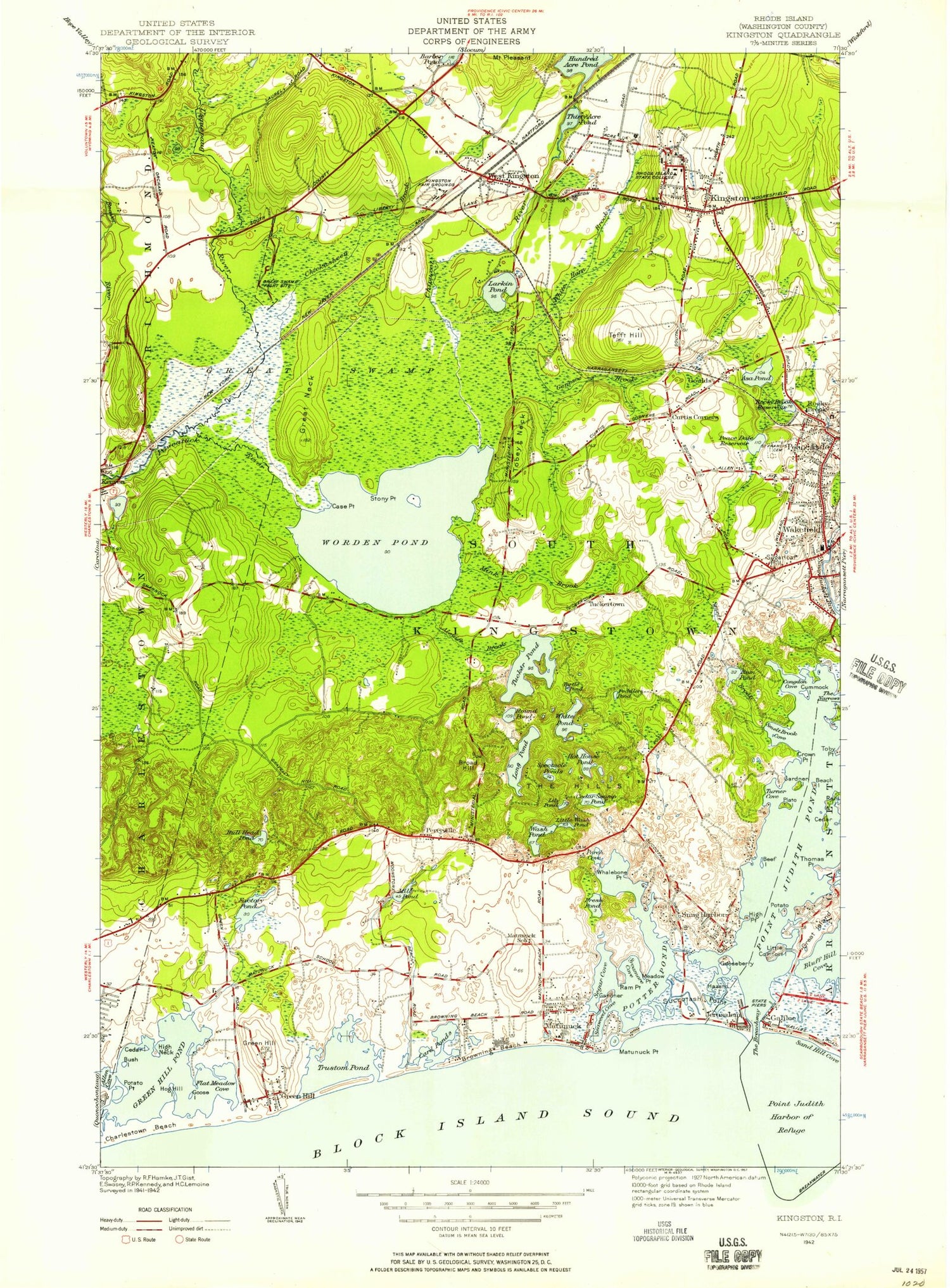
Classic USGS Kingston Rhode Island 7.5'x7.5' Topo Map
Couldn't load pickup availability
Historical USGS topographic quad map of Kingston in the state of Rhode Island. Typical map scale is 1:24,000, but may vary for certain years, if available. Print size: 24" x 27"
This quadrangle is in the following counties: Washington.
The map contains contour lines, roads, rivers, towns, and lakes. Printed on high-quality waterproof paper with UV fade-resistant inks, and shipped rolled.
Contains the following named places: Galilee, Allen Cove, Sagebed Island, Ram Island, Green Hill Pond, Green Hill Beach, Goose Island, Hog Hill Island, Jacob Island, Flat Meadow Cove, Limber Point, Tuck Point, Factory Pond, Green Hill Swamp, Green Hill, Green Hill Point, Green Hill, Trustom Pond, Moonstone Beach, Browning Beach, Mill Pond, Blackberry Hill, Matunuck, Matunuck Point, Deep Hole, Squally Point, Seaweed Cove, Segar Cove, Ram Point, Sycamore Cove, Meadow Point, Potter Pond, Fresh Pond, Perch Cove, Snug Harbor, Hazard Island, Succotash Point, Jerusalem, The Breachway, Little Comfort Island, Strawberry Hill, Potato Island, Beef Island, Thomas Point, Jonathan Island, Jumping Hill, Turner Cove, Plato Island, Beach Island, Camp Fuller, Crown Point, Toby Point, Smelt Brook Cove, Buttonwood Point, Smelt Brook, Rum Pond, The Pots, Congdon Cove, Cummock Island, Bull Head Pond, Perryville, Broad Hill, Wash Pond, Little Wash Pond, Cedar Swamp Pond, The Hills, Spectacle Ponds, Hot House Pond, Long Pond, Round Pond, White Pond, Peddlers Pond, Turtle Pond, Tucker Pond, Alewife Brook, Tuckertown Four Corners, Tuckertown, Little Sugarloaf Hill, Sugarloaf Hill, Browns Brook, Worden Pond, Knowles Point, Stony Point, Case Point, Rocky Brook, Rocky Brook Reservoir, Peace Dale Reservoir, Curtis Corner, Asa Pond, Genesee Brook, Gould, Genesee Swamp, Tobey Neck, Tefft Hill, Kingston, White Horn Brook, Thirty Acre Pond, West Kingston, Larkin Pond, Camp Hoffman, Kingston Station, Chipuxet River, Usquepaug River, Great Neck, Great Swamp, Lily Pond, Mink Brook, Chickasheen Brook, Pine Tree Point, Betty Hull Point, Bush Island, Dead Man Spring, Bill Island, Albro Island, Great Island, Genesee Woods, Billington Cove, Flat Meadow Point, Browning Point, Card Ponds, Whaleboat Point, Turner Point, South Jerry Cove, Stallion Cove, Washington County, WRIU-FM (Kingston), Reel Point, Kingston Hill, Sand Hill Cove, Point Judith Pond, Wakefield, Champlin Cove (historical), Richmond Airport, Great Swamp Goose Marsh, Great Swamp Goose Marsh Dam, Gooseberry Island, Horseshoe Point, Cedar Island, Gardner Island, Gooseberry Island, Point Judith Harbor of Refuge, Bluff Hill Cove, Gardner Island, Cedar Island, Town of South Kingstown, A B Carpenters Beach, Cards Camp, Carpenters Grist Mill, Charlestown Post Office, Curtis Corner Baptist Church, Deep Hole Public Fishing Area, East Matunuck State Beach, First Church of the Nazarene, Galilee Beach Club Beach, Galilee Bird Sanctuary, Galilee Salt Pond Harbor, Great Swamp Wildlife Reservation, Hazard Memorial Library, High Neck, High Point, Kingston Post Office, Maple Lake, Matunuck Beach, Matunuck School, New Life Assembly Church, Perryville Baptist Church, Perryville State Trout Hatchery, Robert Beverly Hale Memorial Library, Roy Carpenters Beach, Saint Francis Church, Salty Brine State Beach, Sand Hill Cove State Beach, South Kingstown Public Library, South Kingston Town Hall, South Road Elementary School, South Shore Management Area, Theater by the Sea, Trustom Pond National Wildlife Refuge, West Kingston Post Office, Willow Dell Beach, West Kingston Baptist Church, Wakefield Elementary School, University of Rhode Island, Wakefield Baptist Church, Unitarian Universalist Congregation of South County, South Kingstown Junior High School, South County Center for the Performing Arts, South County Art Association, Saint Augustines Church, Pettaquamscutt Historical Society Library, Pettaquamscutt Historical Society Building, Peace Dale Historic District, Peace Dale Elementary School, Old Washington County Jail, Oliver Watson Farm (historical), Oliver Watson House, Old Washington County Courthouse, Kingston Congregational Church, Kingston Fairgrounds, Kingston Free Library Branch South Kingston Public Library, Kingston Village Historic District, Laurel Lane Golf Course, Lutheran Church of the Good Shepherd, Christ the King Church, Christ United Methodist Church, Fayerweather House, New Fernwood Cemetery, Great Swamp Fight Site, Helme House Gallery, Succotash Marsh State Management Area, Kingston Census Designated Place, Wakefield-Peace Dale Census Designated Place, First Step at Kingston, Growing Children of Rhode Island Day Care Center, Kingston Fire Department, Matunuck Volunteer Fire Department, Union Fire District Peacedale Station, Red House, Snug Harbor Volunteer Fire Department, South Kingstown Police Department, Tuckertown Fire Department, University of Rhode Island Library, Cane Educational Center, Compass Charter School, Curtis Corner Middle School, Quest Montessori School, The Farm School, University of Rhode Island Child Development Center, University of Rhode Island Kingston Campus, Village Cooperative Nursery School, West Kingston Elementary School, Teal Pond, West Kingston Fire Department, South Kingstown Police Department, University of Rhode Island Emergency Medical Services, Ladd Cove