MyTopo
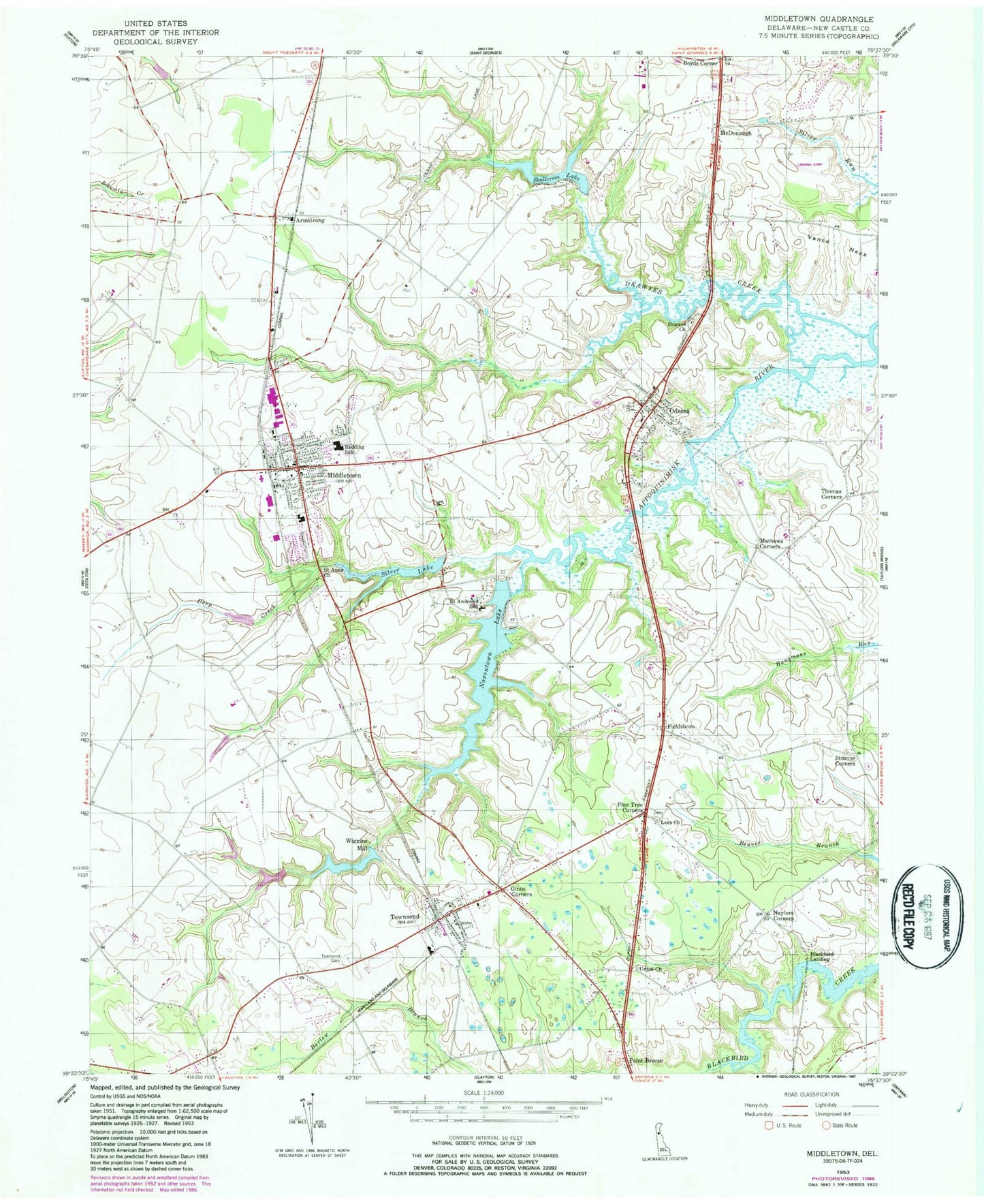
Classic USGS Middletown Delaware 7.5'x7.5' Topo Map
Couldn't load pickup availability
Historical USGS topographic quad map of Middletown in the state of Delaware. Map scale may vary for some years, but is generally around 1:24,000. Print size is approximately 24" x 27"
This quadrangle is in the following counties: New Castle.
The map contains contour lines, roads, rivers, towns, and lakes. Printed on high-quality waterproof paper with UV fade-resistant inks, and shipped rolled.
Contains the following named places: Achmester, Appoquinimink Library, Armstrong, Bethesda United Methodist Church, Blackbird Landing, Brick Mill Elementary School, Chestnut Hill, Connection Community Church, Corbit - Calloway Memorial Library, Corbit Cemetery, Corbit School, Crossroads Presbyterian Church, Dales United Methodist Church, Deep Branch Farm, Deep Creek, Delaware State Police Troop 9, Drawyer Creek, Evergreen Acres, Evergreen Acres Airport, Evergreen Farms, Fieldsboro, Forest Cemetery, Forest United Presbyterian Church, Gander Hill, Ginns Corners, Grace Orthodox Presbyterian Church, Great Oak Farms, Greylag, H and H Corner, Haven Methodist Church, Herring Run, Immanuel United Methodist Church, Kingdom Hall, Lee's Cemetery, Lees Chapel, Mathews Corners, McDonough, McDonough House, Mckeown Airport, Meadow Vista, Middletown, Middletown Church, Middletown High School, Middletown Police Department, Middletown Post Office, Middletown Town Hall, Middletown-Odessa Division, Mid-Town Tabernacle, Mission Fellowship Church, Mount Calvary Baptist Church, Naylors Corners, New Castle County Emergency Medical Services Paramedic Station 5, Noxontown, Noxontown Lake, Odessa, Odessa Fire Company Station 24, Odessa Fire Company Station 4, Odessa Heights, Odessa Post Office, Okolona Plantation Airport, Old Drawyer Church, Old Drawyers Church Cemetery, Old Saint Anne's Church Cemetery, Old Union Church, Pine Tree Corners, Point Breeze, Redding Middle School, Rehoboth Church, Ringgold Chapel, Rose Valley Estates, Saint Andrews School, Saint Andrews School Chapel, Saint Annes Church, Saint Anns Church, Saint Josephs Catholic Church, Saint Pauls United Methodist Church, Shallcross House, Shallcross Lake, Shallcross Lake Dam, Silver Lake, Silver Lake Dam, Silver Lake Elementary School, Silver Lake Park, Stumps Corners, Succor Corners, Sugar Loaf Chase, Sycamore Farms, Taylors Corner, The Broadmeadow School, Thomas Corners, Town of Middletown, Town of Odessa, Town of Townsend, Townsend, Townsend A Airport, Townsend Cemetery, Townsend Elementary School, Townsend Fire Company Station 26, Townsend Post Office, Trinity African Methodist Episcopal Church, Volunteer Hose Company of Middletown Station 27, Wiggins Mill, Wiggins Mill Park, Wiggins Mill Pond, Wiggins Mill Pond Dam, Woodlawn, Zore United Methodist Church, ZIP Codes: 19709, 19730, 19734