MyTopo
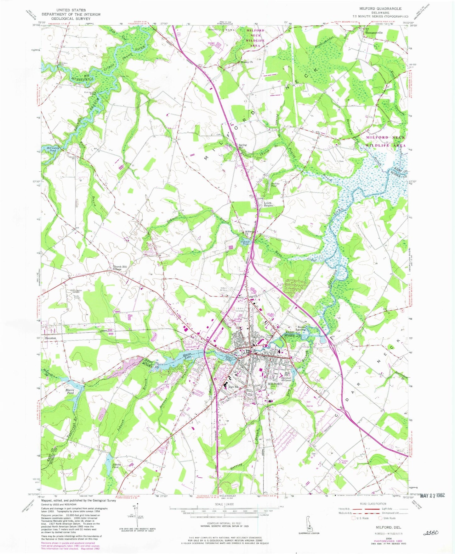
Classic USGS Milford Delaware 7.5'x7.5' Topo Map
Couldn't load pickup availability
Historical USGS topographic quad map of Milford in the state of Delaware. Map scale may vary for some years, but is generally around 1:24,000. Print size is approximately 24" x 27"
This quadrangle is in the following counties: Kent, Sussex.
The map contains contour lines, roads, rivers, towns, and lakes. Printed on high-quality waterproof paper with UV fade-resistant inks, and shipped rolled.
Contains the following named places: Abbotts Mill, Abbotts Pond, Abbotts Pond Dam, Ash Gut, Avenue United Methodist Church, Bayhealth Milford Memorial Hospital, Beaverdam Branch, Benjamin Banneker Elementary School, Berean Community Church, Bethel African Methodist Episcopal Church, Big Cripple Swamp, Blairs Pond, Blairs Pond Dam, Bowen Landing, Bowman Branch, Brown Street, Browns Branch, Burton - Derrickson Tract of Murderkill River Nature Preserve, Calvary Methodist Church, Carlisle Fire Company, Carpenters Bridge, Chestnut Knoll, Church Hill Village, City of Milford, Colony West, Copper Branch, Country Club Estates, Deep Branch, Dogwood Meadows, Donovan Development, Drummond Airport, Eastman Heights, Evergreen Acres, Faith Baptist Church, Farm View Park, First Baptist Christian School, First Baptist Church, First Church of Christ Scientist, Fishing Branch, Fork Landing Bridge, Frederica First Baptist Church, Freeman Corner, Greater Milford Business Complex, Griffith Lake, Griffith Lake Dam, Hall Estates, Haven Lake, Haven Lake Dam, Haven Lake Estates, Herring Branch, Herrings Corners, Hummingbird Hills, Ice Cream Island, Improvement Branch, Independent Order of Odd Fellows Cemetery, Jenkins Pond, Johnson Branch, Kent County Regional Wastewater Treatment Facility, Kent County Sewer Treatment Plant, Kimbowrosa Farm Airport, Kings Causeway Branch, Knotts Landing, Lakewood, Lakewood Development, Lednum Branch, Lighthouse Christian Center, Lulu M Ross Elementary School, Lynch Heights, Lynch Heights Baptist Church, Marshall Millpond, Marshall Millpond Dam, Masten Industrial Park, McColley Pond, Meadow Gate Acres, Mikros Christian School, Milford, Milford Airpark, Milford Church of Christ, Milford Church of God, Milford Church of the Nazarene, Milford City Hall, Milford Crossing, Milford First Baptist Christian School, Milford Hundred, Milford Lakeview School, Milford Meadows, Milford Plaza, Milford Police Department, Milford Post Office, Milford Public Library, Milford Senior High School, Milford Shopping Center, Milford Village Shopping Center, Millwood Church, Mispillion Marina, Mullet Run, New Wharf, North Milford, North Shores, Old Baptist Church Branch, Parnell Branch, Pilgrim Wesleyan Church, Presbyterian Branch, Reformation Lutheran Church, Saint Johns Catholic Church, Shawnee, Shawnee Acres, Shawnee Country Club, Silver Lake, Silver Lake Dam, South Bowers Volunteer Fire Company Station 57, South Milford, Spring Hill, Stanley Manor, State of Delaware, Stevenson Detention Center, Swan Creek, Tantrough Branch, The Heath, Thompsonville, Tubmill Branch, Tubmill Pond, Tubmill Pond Dam, WAFL-FM (Milford), Ward Branch, Webb Manor, Wesley Church, White Oak Mobile Home Park, Wisseman Acres, Woods Haven, WYUS-AM (Milford)