
MyTopo
Classic USGS Newport Rhode Island 7.5'x7.5' Topo Map
Couldn't load pickup availability
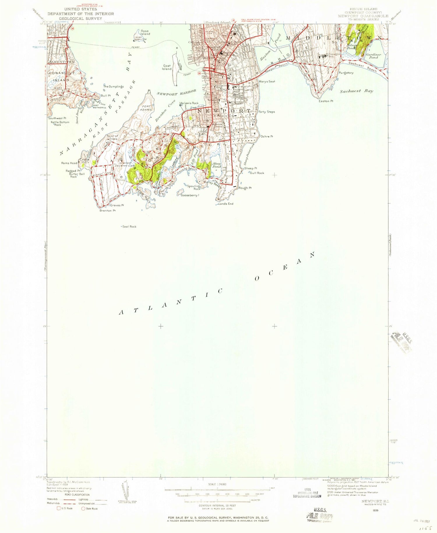
Historical USGS topographic quad map of Newport in the state of Rhode Island. Map scale may vary for some years, but is generally around 1:24,000. Print size is approximately 24" x 27"
This quadrangle is in the following counties: Newport.
The map contains contour lines, roads, rivers, towns, and lakes. Printed on high-quality waterproof paper with UV fade-resistant inks, and shipped rolled.
Contains the following named places: Almy Pond, Ann Street Pier, Aquidneck Elementary School, Aquidneck Island Christian Academy, Aquidneck School, Army and Naval YMCA, Artillery Company of Newport Military Museum, Atlantic Beach, Bailey Beach, Banisters Wharf, Beach Rock, Belcourt Castle, Bellevue Avenue Historic District, Bellevue Avenue-Casino Historic District, Bellevue Shopping Center, Black Rock, Boat House Gully, Bowens Wharf, Braman Cemetery, Brenton Cove, Brenton Point, Brenton Reef, Brenton Village, Brick Market, Brick Market Place, Broadway Post Office, Brown Howard Wharf, Bull Point, Butter Ball Rock, Callender School, Cardines Field, Carey School, Castle Hill, Castle Hill Coast Guard Station, Castle Hill Cove, Castle Hill Light, Chateau Sur-Mer Mansion, Cherry Neck, Christines Landing, Citing Rock, City of Newport, Clark School, Coddington Cemetery, Coddington Wharf, Coggeshall Ledge, Collins Beach, Colonial Jewish Cemetery, Common Burial Ground Cemetery, Concord Gulf Cove, Conrad Cove, Cranston-Calvert School, De La Salle Academy, Dyer Point, Easton Bay, Easton Beach, Easton Point, Easton Pond, Easton Pond South Dam, Edward King House, Eisenhower Park, Elbow Ledge, Ellerys Ferry Wharf, Ellison Rock, Fort Adams, Fort Adams Light, Fort Adams State Park, Fort Cove, Fort Dumpling, Fort Wetherill, Fort Wetherill State Park, Forty Steps, Frank E Thompson Middle School, Freebody Park, Friends Meeting House, Gardiner Pond, Gardiner Pond Dam, Gardners Wharf, Garretson Memorial Day Nursery, Gateway Visitors Center, Goat Island, Goat Island Yacht Club, Goose Neck, Goose Neck Cove, Gooseberry Beach, Gooseberry Island, Governor Benedict Arnold Graveyard, Graves Point, Green End Pond, Green End Pond Dam, Gull Rock, Hammersmith Farm, Hanging Rock, Hatch School, Haycock Ledge, Hazard Beach, Howard Wharf, Hunter Playfield, Ida Lewis Rock, Ida Lewis Rock Light, Ida Lewis Yacht Club, Ina Mosher Health Sciences Library, International Tennis Hall of Fame, International Tennis Hall of Fame Library, International Yacht Restoration School, Island Cemetery, J Paul Braga Junior Memorial Field, Jamestown, Jamestown Fire Department, Jamestown Fire Department Memorial Museum, Jamestown Philomenian Library, Jamestown Town Cemetery, Jamestown Town Hall, Kay Street-Catherine Street-Old Beach Road Historic District, Kettle Bottom Rock, King Park, King Park Beach, Kingscote Mansion, Lands End, Lees Wharf, Lenthal School, Lily Pond, Lime Rock Light, Little Ida Lewis Rock, Long Rock, Long Wharf, Long Wharf Mall Shopping Center, Long Wharf Mill, Lopezs Wharf, Maiford River, Maltbones Wharf, Marble House, Marys Seat, Meadowlark Campground, Midship Rock, Mitchell Rock, Morton Park, Mumford School, Murphy Field, Museum of Newport History, Nelson Pond, Nelson Pond Dam, Newport, Newport Art Museum, Newport Artillery Company Armory, Newport Casino, Newport City Hall, Newport Country Club, Newport County, Newport County Career and Technical Center, Newport County Courthouse, Newport Harbor, Newport Harbor Light, Newport Harbor Lighthouse, Newport Historic District, Newport Historical Society and Museum, Newport Historical Society Library, Newport Hospital, Newport Museum of Costume, Newport Neck, Newport Post Office, Newport Public Library, Newport Ship Yard, Norman Bird Sanctuary, Ocean Drive Historic District, Ocean Drive State Park, Ochre Point, Ochre Point-Cliffs Historic District, Old City Cemetery, Old Salt Work Beach, Old Stone Mill, Overings Wharf, Paradise Brook, Peases Wharf, Perry Mill, Perry Mill Wharf, Pirate Cave, Pitts Head Tavern, Point of Trees, Potter School, Price Neck, Purgatory, Queen Anne Square, Ragged Point, Rams Head, Redwoods Wharf, Roaring Bull, Rochambeau Statue and Monument, Rogers High School, Romes Wharf, Rose Island, Rose Island Light, Rough Point, Sachuest Bay, Saing Georges School, Saint Catherines Academy, Saint Georges School, Saint Joseph of Cluny Sisters School, Saint Mary's Cemetery, Saint Michaels Country Day School, Saint Patrick Rock, Salve Regina University, Sand Beach Cove, Sanford-Covell Villa Marina, Sayer Wharf, Scotts Wharf, Sea Rangers Nursery School, Seal Ledge, Seal Rock, Second Beach, Sheep Pen Rock, Sheep Point, Sheep Point Cove, Slocums Wharf, Spouting Rock, Spring Wharf, Stanton Reef, Stony Reef, Storer Park, Supp Rock, Taylors Wharf, The Bluff, The Dumplings, The Point, The Poplar School, Touro Park, Tracey Ledge, Trinity Church Yard Cemetery, Trinity School House, Van Zandt Pier, Waites Wharf, Wantons Wharf, Washington Square, West Cove, William J Underwood School, ZIP Code: 02840


