
MyTopo
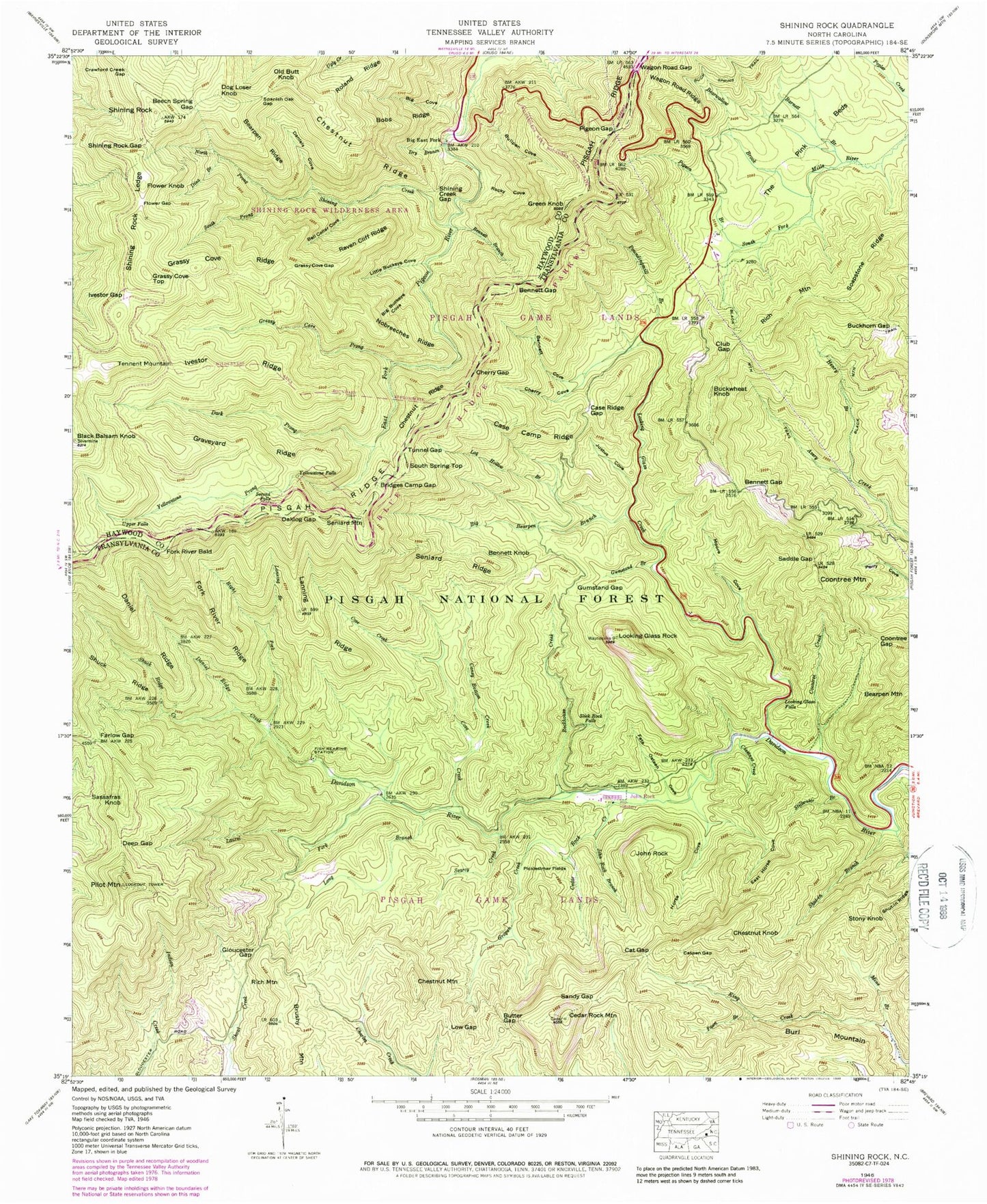
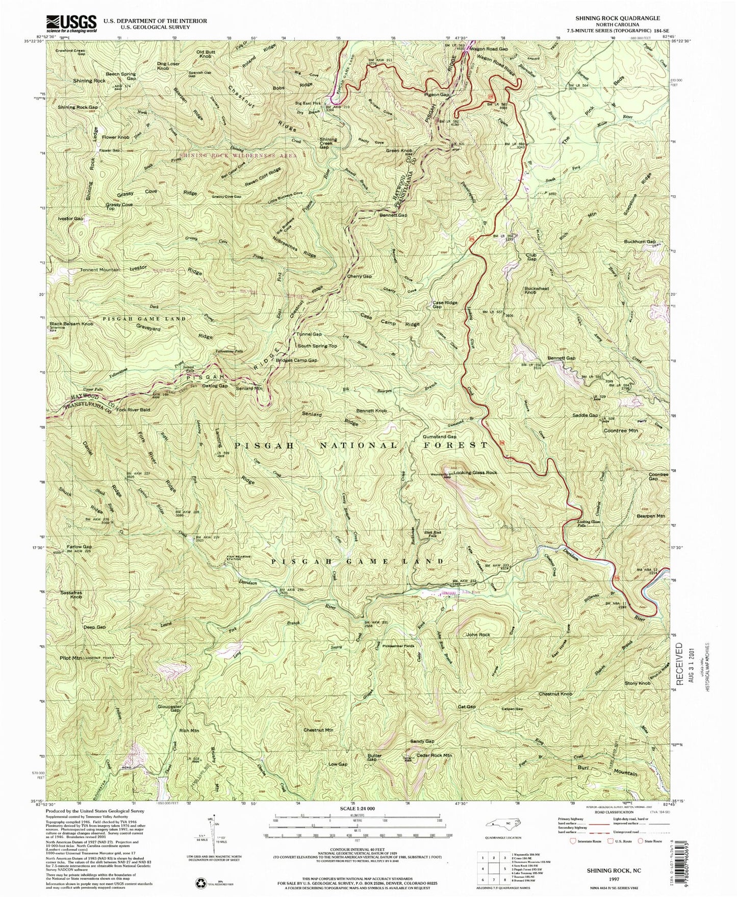
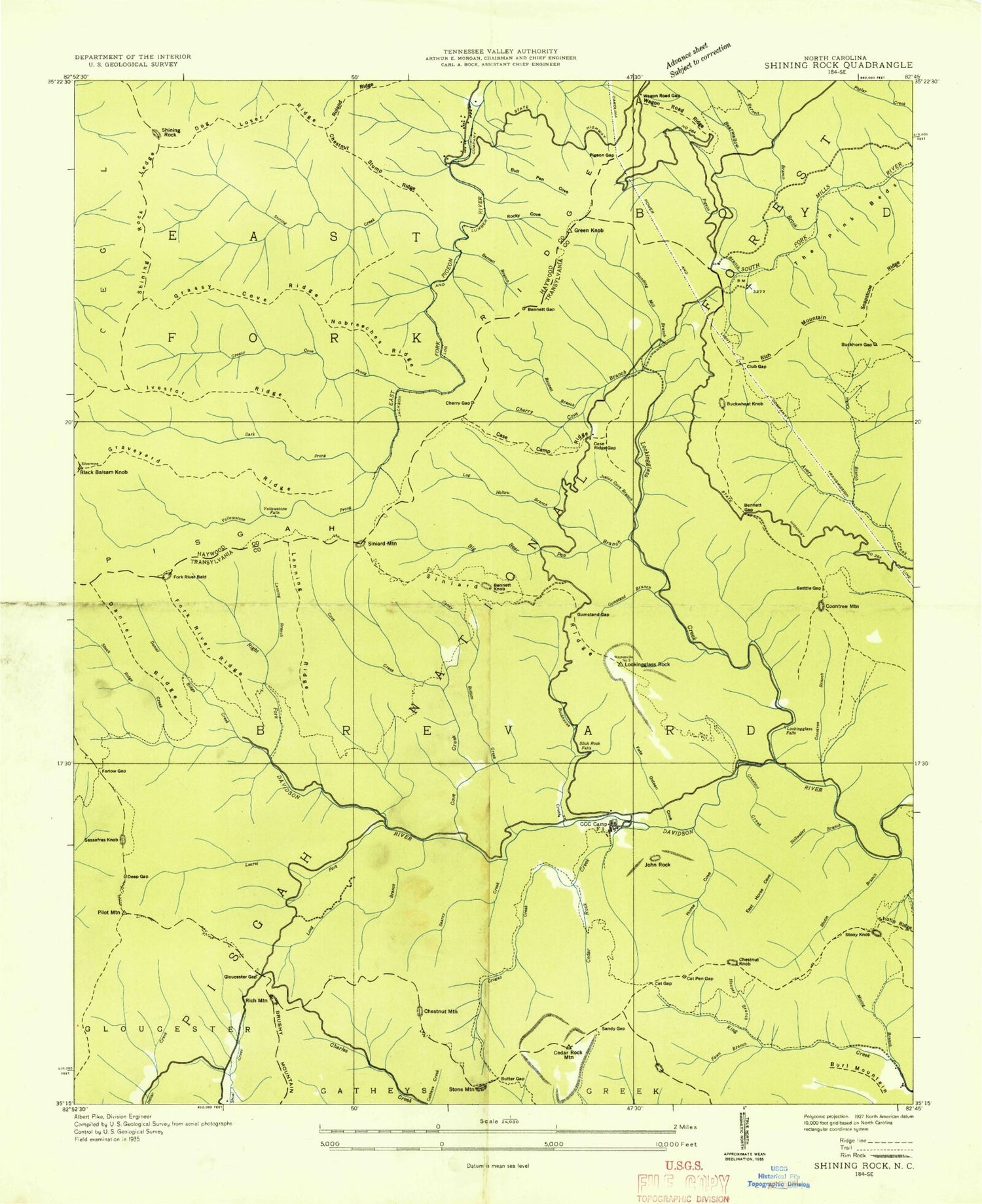
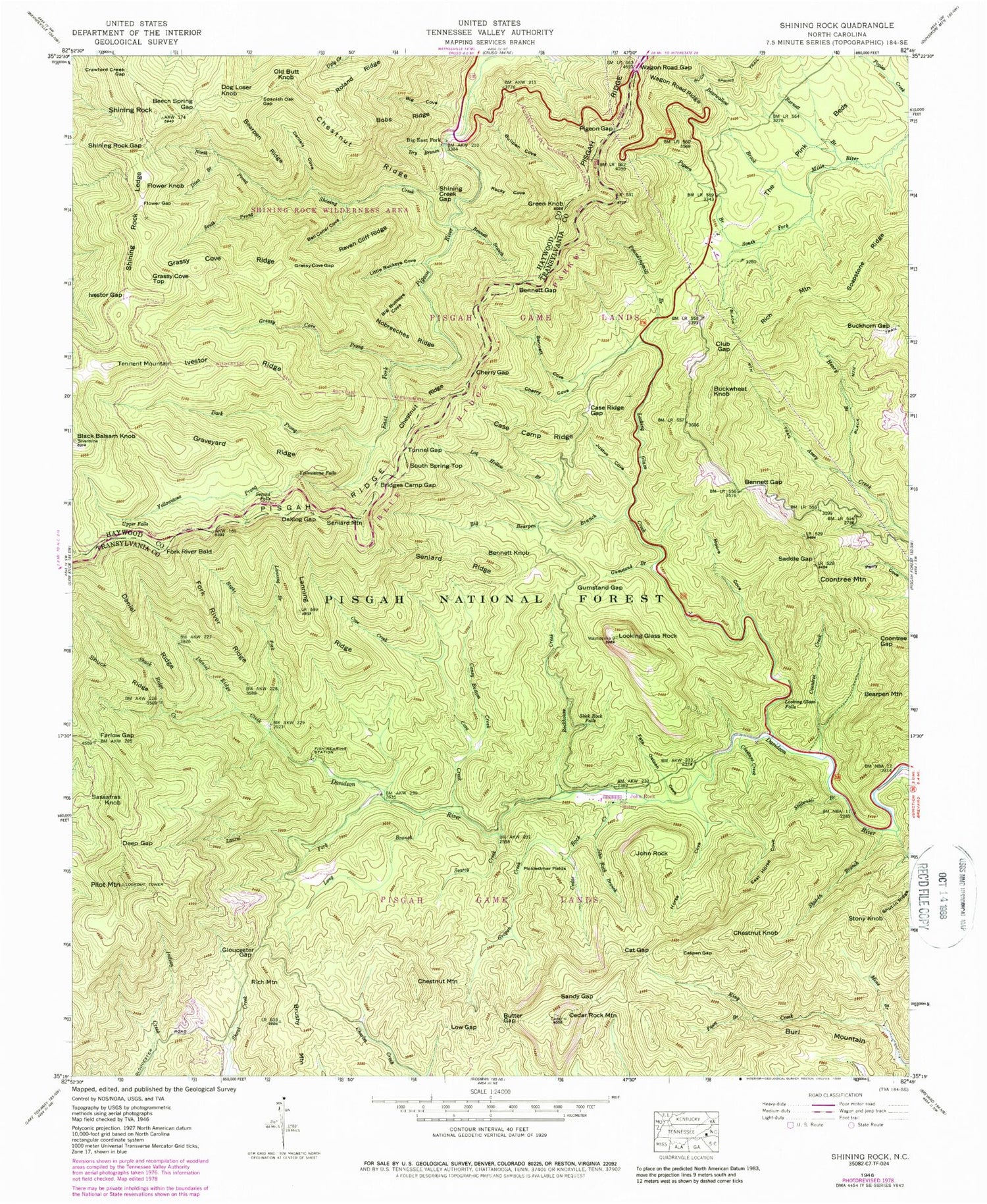
USGS Classic Shining Rock North Carolina 7.5'x7.5' Topo Map
Couldn't load pickup availability
Historical USGS topographic quad map of Shining Rock in the state of North Carolina. Scale: 1:24000. Print size: 24" x 27"
This quadrangle is in the following counties: Haywood, Transylvania.
The map contains contour lines, roads, rivers, towns, lakes, and grids including latitude / longitude and UTM / MGRS. Printed on high-quality waterproof paper with UV fade-resistant inks.
Contains the following named places: Barnett Branch, Bearpen Ridge, Bearwallow Brook, Beech Spring Gap, Bell Collar Cove, Bennett Branch, Bennett Cove, Bennett Gap, Bennett Gap, Big Bearpen Branch, Big Buckeye Cove, Big Cove, Black Balsam Knob, Bobs Ridge, Bridges Camp Gap, Buckhorn Gap, Bullpen Cove, Butter Gap, Caney Bottom Creek, Case Camp Ridge, Case Ridge Gap, Cat Gap, Catpen Gap, Cedar Rock Creek, Cedar Rock Mountain, Cherry Cove, Cherry Gap, Chestnut Creek, Chestnut Ridge, Chestnut Ridge, Club Gap, Coontree Creek, Coontree Gap, Cove Creek, Crawford Creek Gap, Daniel Ridge, Daniel Ridge Creek, Daniels Cove, Dark Prong, Deep Gap, Dina Branch, Dry Branch, East Horse Cove, Farlow Gap, Fate Osteen Cove, Fawn Branch, Flower Gap, Fork River Ridge, Gloucester Gap, Grassy Cove Gap, Grassy Cove Ridge, Graveyard Ridge, Greasy Cove Prong, Green Knob, Grogan Creek, Gumstand Branch, Gumstand Gap, Henry Branch, Horse Cove, Ivestor Gap, Ivestor Ridge, John Rock, John Rock Branch, Justus Cove, Lanning Branch, Lanning Ridge, Laurel Fork, Little Buckeye Cove, Log Hollow Branch, Long Branch, Looking Glass Creek, Looking Glass Falls, Looking Glass Rock, Low Gap, Mine Branch, Moore Cove, Nobreechies Ridge, North Prong Shining Creek, Oaklog Gap, Picklesimer Fields, Pigeon Branch, Pigeon Gap, Raven Cliff Ridge, Right Fork Davidson River, Rockhouse Creek, Rocky Cove, Roland Ridge, Saddle Gap, Sandy Gap, Searcy Creek, Second Falls, Seniard Ridge, Shining Creek, Shining Creek Gap, Shining Rock Gap, Shining Rock Ledge, Shuck Ridge Creek, Shut-in Branch, Shut-in Ridge, Slick Rock Falls, Soapstone Ridge, South Prong Shining Creek, Spanish Oak Gap, Stillwater Branch, The Pink Beds, Tunnel Gap, Upper Falls, Wagon Road Gap, Wagon Road Ridge, Yellowstone Falls, Yellowstone Prong, Shining Rock Parking Area, Buckhorn Shelter, Cove Creek Campground, Deep Gap Shelter, Butter Gap Shelter, John Rock Scenic Area, Cradle of Forestry in America, Art Loeb Trail, Bennett Knob, Big East Fork, Brushy Mountain, Buckwheat Knob, Burl Mountain, Chestnut Knob, Chestnut Mountain, Coontree Mountain, Dog Loser Knob, Flower Knob, Fork River Bald, Grassy Cove Top, John Rock, Old Butt Knob, Pilot Mountain, Poundingmill Branch, Rich Mountain, Rich Mountain, Sassafras Knob, Seniard Mountain, Shining Rock, South Spring Top, Stony Knob, Tennent Mountain, Looking Glass Rock Scenic Area, Coontree Picnic Area, Cradle of Forestry in America Visitor Center, Pink Bed Picnic Area, Sliding Rock Recreation Site, Township of Brevard