MyTopo
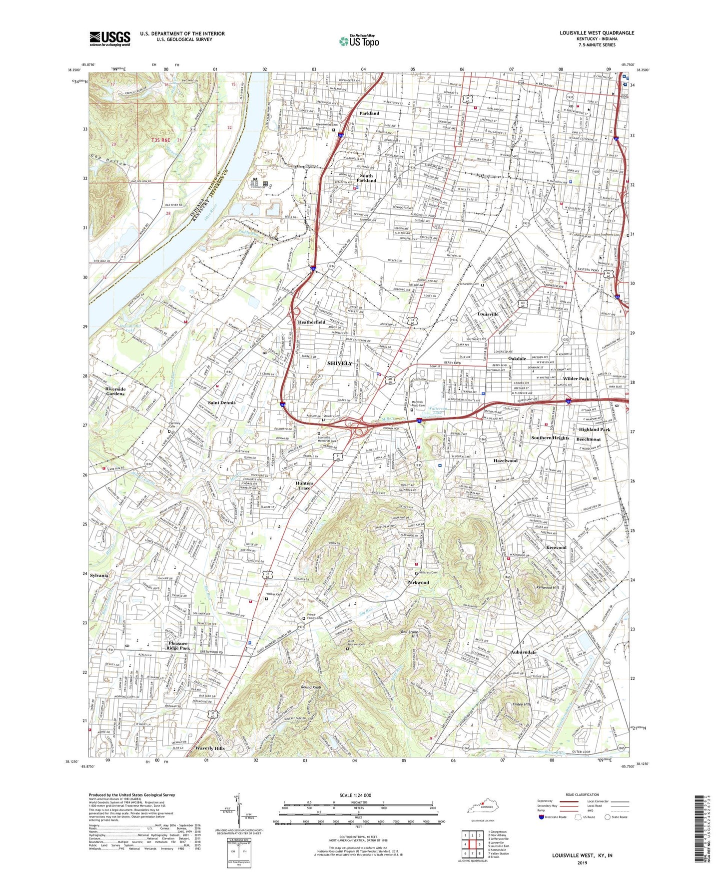
Louisville West Kentucky US Topo Map
Couldn't load pickup availability
2019 topographic map quadrangle Louisville West in the states of Kentucky, Indiana. Scale: 1:24000. Based on the newly updated USGS 7.5' US Topo map series, this map is in the following counties: Jefferson, Floyd. The map contains contour data, water features, and other items you are used to seeing on USGS maps, but also has updated roads and other features. This is the next generation of topographic maps. Printed on high-quality waterproof paper with UV fade-resistant inks.
Quads adjacent to this one:
West: Lanesville
Northwest: Georgetown
North: New Albany
Northeast: Jeffersonville
East: Louisville East
Southeast: Brooks
South: Valley Station
Southwest: Kosmosdale
Contains the following named places: Ackerly-Bingham Guidance Special Education High School, Ackerly-Bingham Guidance Special Education School, Ahrens Educational Resource Center, Algonquin Park, Angela Merici High School, Auburndale, Auburndale Elementary School, Beechmont, Beechmont School, Belknap Campus Historical Marker, Bettie Johnson Hall, Big Run, Bishop David High School, Brandeis School, Brown School, California Park, Calvary Baptist Church Historical Marker, Calvary Episcopal Church Historical Marker, Cane Run, Cane Run School, Cardinal Hill Reservoir, Caritas Occupational Health Center, Carter Traditional Elementary School, Center Street Colored Methodist Episcopal Church-Chestnut Street Colored Methodist Episcopal Church Historical Marker, Central Colored School Historical Marker, Central Park, Central Station Shopping Center, Charles H Parrish Junior Historical Marker, Churchill Downs, Churchill Downs Heliport, Churchill Downs Historical Marker, Churchill Park, Churchill Park School, City of Shively, Civil Rights Struggle Historical Marker, Cochran Elementary School, Colonel Reuben T Durrett Home Historical Marker, Concentra Medical Centers, Conway Middle School, Cotter-DuValle School, Crums Lane School, Dawson Orman Education Center, Deker College, DeSales High School, Dixie Manor Shopping Center, Doctor James Bond Historical Marker, Doss High School, Doss High School Magnet Career Academy, Dreamland Lake, Du Pont Manual High School, DuValle Education Center, Eisenhower Elementary School, Engelhard Elementary School, Farnsley Cemetery, Farnsley Middle School, Finley Hill, Fort Southwood Historical Marker, Frayser School, Frazier Rehabilitation Institute, French Creek, Gap Hollow, Gheens Science Hall, Gilded Age Mansions Historical Marker, Greenwood Cemetery, Greenwood Elementary School, Greenwood School, Gutermuth Elementary School, Harris Park, Hazelwood, Hazelwood Elementary School, Hazelwood Sanatorium, Hazelwood School, Heatherfield, Henry Watterson Historical Marker, Highland Park, Hillcrest Cemetery, Holy Cross School, Holy Rosary Academy, Hunters Trace, Iroquois High School, Iroquois Manor Shopping Center, Iroquois Middle School Magnet Career Academy, Iroquois Park, Jacob Elementary School, Jacob School, Jacobs Addition, Jefferson Community College, Jefferson Community College Preschool, Jefferson County High School, Jefferson Seminary Historical Marker, Jennie Benedict Historical Marker, Jerome Clarke Historical Marker, Jewish Hospital, John F Kennedy Montessori Elementary School, Johnson Traditional Middle School, Jones School, Jubilee Early Childhood Preschool Center, Keller Day Treatment Center Alternative School, Kennedy School, Kenwood, Kenwood Drive-In, Kenwood Hill, Kenwood School, Kerrick School, Knights of Pythias Temple Historical Marker, Lassiter Middle School, Little Africa Historical Marker, Loretto High School, Louis D Brandeis Historical Marker, Louis Dembitz Brandeis Historical Marker, Louisville and Nashville Railroad Historical Marker, Louisville Central Division, Louisville Deaf Oral School, Louisville Free Public Library Historical Marker, Louisville Girls High School Historical Marker, Louisville Junior Academy, Louisville Medical College Historical Marker, Louisville Memorial Park, Louisville Municipal College Historical Marker, Louisville Rifle and Gun Club, Louisville South Division, Louisville Western Branch Library Historical Marker, Lutz Hall, Lyles Mall Shopping Center, Male High School, Manly Junior High School, Manslick Road Cemetery, Mary Ryan Academy Special Education School, McDonalds Field, McFerran School, Medical College, Memorial Auditorium Historical Marker, Miles Park, Mill Creek, Mill Creek School, Morris Forman Wastewater Treatment Plant, Newtown, North Dixie Division, Norton Hospital, Norton Infirmary, Oak Saint Yards, Oakdale, Our Lady of Mount Carmel School, Paddy Run, Papa Johns Cardinal Stadium, Park Place Plaza Shopping Center, Parkhill Center, Parkland, Parkland Junior High School, Parkland School, Parkway Field, Parkwood, Perry School, Pine Run, Pleasure Ridge Park, Pleasure Ridge Park Census Designated Place, Presentation Academy Historical Marker, Prince Family Cemetery, Red Stone Hill, River City Transit Authority, Riverside Gardens, Rockford Lane School, Round Knob, Ruff Memorial-Wheelmens Bench Historical Marker, Rutherford School, Saint Andrews Catholic Church Historical Marker, Saint Andrews Cemetery, Saint Ann School, Saint Basil School, Saint Denis, Saint Dennis, Saint Dennis Census Designated Place, Saint Lawrence School, Saint Marys Medical Mall, Saint Stephens Cemetery, Saint Thomas More School, Saints Mary and Elizabeth Hospital, Schaffner Traditional Elementary School, Schardein Cemetery, Scottish Rite Temple Historical Marker, Semple School, Shively, Shively Center Shopping Center, Shively Park, Simmons College of Kentucky, Simmons University Historical Marker, South Central Park, South Louisville Yards, South Parkland, Southern Heights, Southland Terrace Shopping Center, Southwest Government Center Heliport, Southwick School, Spalding University, Stephen Foster School, Stowers Cemetery, Suda E Butler Traditional High School, Sylvania, Talbert School, Technology Park of Greater Louisville, The Filson Club Historical Society Historical Marker, The Red Barn, Trager Stadium, Tringle Park, Trunnell School, Ulmer Stadium, Unitas Tower, United States Veterans Administration Veterans Outreach Center, University Child Health Specialists Center, University of Louisville, University of Louisville School of Music, Victory Park, Virginia Avenue School, Walker Cemetery, Watterson Lake, Waverly Hills Park, Western High School, Westland Mall Shopping Center, WFPK-FM (Louisville), WFPL-FM (Louisville), Wheatley School, Whiskey Row Historical Marker, Wilder Park, Wilson Creek, WLOU-AM (Louisville), WLRS-FM (Louisville), Woodhaven Geriatrics Hospital, Wyandotte Park, Youngland Historical Marker, ZIP Codes: 40208, 40210, 40211, 40214, 40215, 40216