MyTopo
Bay View Maryland US Topo Map
Couldn't load pickup availability
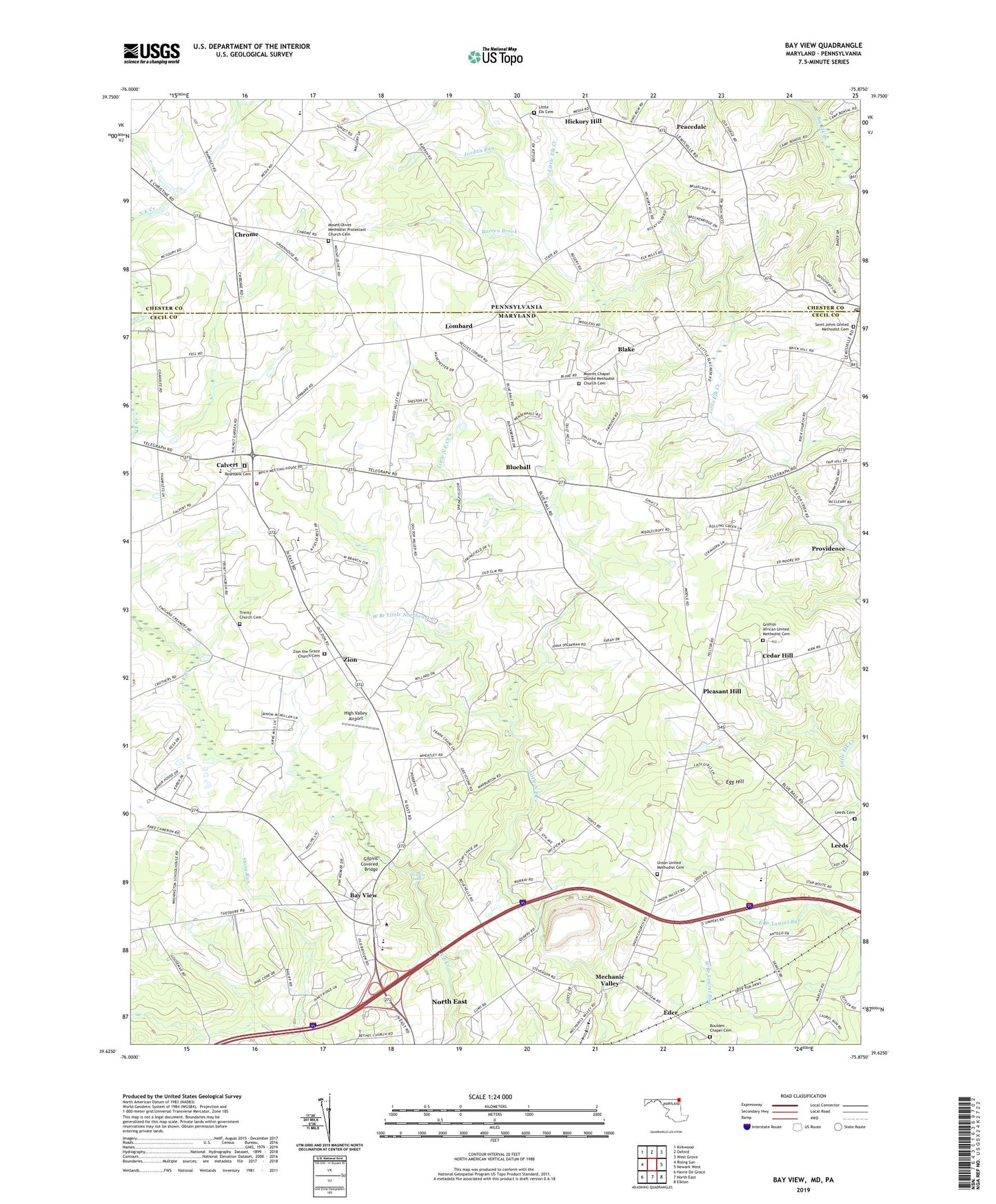
2019 topographic map quadrangle Bay View in the states of Maryland, Pennsylvania. Scale: 1:24000. Based on the newly updated USGS 7.5' US Topo map series, this map is in the following counties: Cecil, Chester. The map contains contour data, water features, and other items you are used to seeing on USGS maps, but also has updated roads and other features. This is the next generation of topographic maps. Printed on high-quality waterproof paper with UV fade-resistant inks.
Quads adjacent to this one:
West: Rising Sun
Northwest: Kirkwood
North: Oxford
Northeast: West Grove
East: Newark West
Southeast: Elkton
South: North East
Southwest: Havre De Grace
Contains the following named places: Barren Brook, Bay View, Bay View Elementary School, Bay View Post Office, Bay View School, Beulah Land, Blake, Blue Ball Village, Blueball, Blueball Post Office, Boomdecker, Boulden Chapel, Boulden Chapel Cemetery, Brick Meeting House, Buena Vista School, Calvert, Calvert Acres, Calvert Elementary School, Calvert Manor Health Care Center Nursing Home, Calvery Post Office, Carters School House, Cecil College Campus Security, Cecil College North East Campus, Cecil County Drag Strip, Cecil County Dragway, Cecil Upper Room Gospel Tabernacle Church, Cecil Vocational Technical Center, Cedar Hill, Chantilly Manor, Chantilly Manor Country Club, Cheasapeake Bay Golf Club North East, Childs Post Office, Chrome, Chrome Barrens, Community Fire Company of Rising Sun Station 18, District 9 Calvert, Eder, Edgewood Hills, Egg Hill, Elk Mills, Elkton Nazarene Church, England Farms, Ewingville, Fair Hill Meadows, Fairfields, Fairview School, Farmcrest, Forest Green Court, Gilpins Covered Bridge, Gilpins Falls, Glen Hope, Gospel Light Church, Griffith African United Methodist Cemetery, Griffith Church, Grove School, Hickory Hill, High Valley Airport, Highpoint, Hillview Estates, Jordan Run, Larsons Farm And Nursery, Leeds, Leeds Cemetery, Leeds Elementary School, Leeds School, Leeds United Methodist Church, Lewisville Post Office, Little Elk Cemetery, Little Elk Chapel, Lombard, Lombard Acres, Long Green Farms, Lum Estates, Marley Village, Mechanic Valley, Mechanics Valley Post Office, Mechanics Valley Quarry, Media Chapel, Mercy Missionary Baptist Church, Middlecroft, Moores Chapel, Moores Chapel United Methodist Church Cemetery, Mount Olivet Church, Mount Olivet Methodist Protestant Church Cemetery, Nellys Corner, Oak Grove School, Old Line Village of Fair Hill, Pawnee Lake Hills, Peacedale, Pearl Estates, Pine Grove Church, Pleasant Hill, Pleasant Hill Lookout Tower, Pleasant Hill Mobile Home Park, Pleasant Hill School House, Pleasant View Farms, Ponds Edge, Poplar Ridge School, Providence, Rising Sun High School, Rock United Presbyterian Church, Rosebank Cemetery, Rosebank United Methodist Church, Saint Johns Church, Saint Johns United Methodist Cemetery, Shah Valley, Shelemiah United Methodist Church, Spirit and Life Bible Church, State Line Church, Stony Chase Court, Tailwinds Estates, The Church of Jesus Christ of Latter Day Saints, The Estates of Wyn Lea, The Rock, Township of Elk, Trinity Church, Trinity Church Cemetery, Union Church, Union School, Union United Methodist Cemetery, Union Valley, Warburton School, Washington School House, West Branch Little Northeast Creek, Westminister, White Oak School, Windmill Farm, Wyn Lea at Fair Hill, Zion, Zion Acres, Zion Post Office, Zion Presbyterian Church, Zion the Grace Bible Church, Zion the Grace Church Cemetery, Zion United Methodist Church