MyTopo
Myersville Maryland US Topo Map
Couldn't load pickup availability
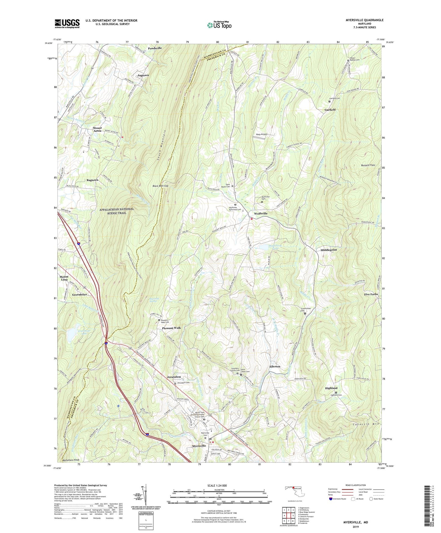
2019 topographic map quadrangle Myersville in the state of Maryland. Scale: 1:24000. Based on the newly updated USGS 7.5' US Topo map series, this map is in the following counties: Frederick, Washington. The map contains contour data, water features, and other items you are used to seeing on USGS maps, but also has updated roads and other features. This is the next generation of topographic maps. Printed on high-quality waterproof paper with UV fade-resistant inks.
Quads adjacent to this one:
West: Funkstown
Northwest: Hagerstown
North: Smithsburg
Northeast: Blue Ridge Summit
East: Catoctin Furnace
Southeast: Frederick
South: Middletown
Southwest: Keedysville
Contains the following named places: Alpine View, Annapolis Rock, Ashley, Bagtown, Bagtown Census Designated Place, Bartman Hill, Beaver Creek Estates, Bittle, Black Rock, Black Rock Gap, Blacks Glen, Blank, Bond Farm Pond, Bond Farm Pond Dam, Buhrman, Buzzard Flats, Camp Mount Aetna, Church Hill, Church Hill Estates, Crest Valley, District 16 Jackson, District 6 Catoctin, Dry Run, Eldridge, Ellerton, Fairmount, Fishers Hollow, Five Forks, Five Forks Estates, Flook Farm, Forest School, Garfield, Garfield Cemetery, Garfield United Methodist Church, Green Brier State Park Dam and Dike, Greenbriar Lake, Greenbriar State Park Dike Dam, Greenbrier, Greenbrier State Park, Grossnickle Church, Grossnickle Church of the Brethren Cemetery, Grossnickle School, Harman Branch, Harmony Brethren Church, Harp, Harp Airport, Highfields, Highland, Highland Cemetery, Highland Farms, Highland School, Highland View Academy, Highland Woods, Highlands of Monroe, Jerusalem, Jerusalem Cemetery, Jerusalem Lutheran Church, Jugtown, Jugtown Census Designated Place, June Acres, Lens Rambles, Little Catoctin Creek, Lynch Estates, Maryland Natural Resource Police Department Echo Lake Area Office, McIntyre Estates, Meadow Ridge, Meeting House Overlook, Middle Creek, Middle Creek Estates, Middlepoint, Miller Hill, Monument Knob, Monument School, Mount Aetna, Mount Aetna Academy, Mount Aetna Census Designated Place, Mount Aetna Creek, Mount Aetna School, Mount Aetna Volunteer Fire Department Company 16, Mount Bethel Cemetery, Mount Bethel United Methodist Church, Mount Lena Census Designated Place, Mount Zion Methodist Church, Mount Zion United Methodist Church Cemetery, Mullinix Farm, Myersville, Myersville Baptist Church, Myersville Cemetery, Myersville Community Park, Myersville Elementary School, Myersville Fire Company Station 8, Myersville Post Office, Myersville Springs, Myersville Town Hall, North Lynch Estates, Paintrock Mill, Pine Knob, Pleasant Walk, Pleasant Walk Cemetery, Pleasant Walk School, Pleasant Walk United Methodist Church, Pondsville, Pondsville Census Designated Place, Saint John Lutheran Church, Saint Johns Cemetery, Saint Marks Cemetery, Saint Marks Church, Saint Paul Lutheran Church, Salem United Methodist Church, Second Christian Church, Second Christian Church Graveyard, Sensenbaugh School, Shady Grove, Shiningtree School, Smeltzer, South Mountain Campground, South Mountain Natural Environmental Area, Spruce Run, Summers Family Cemetery, The Cascade, Thunderhill Farms, Town of Myersville, Turkey Hill, Viewpoint, Vista Farms, Waterloo, Way-Stan Farms, West Branch Middle Creek, Wistmans Delight, Wolfe, Wolfes Orchard, Wolfes Overlook, Wolfsville, Wolfsville Cemetery, Wolfsville Crossing, Wolfsville Elementary School, Wolfsville Puritan Park East, Wolfsville Reformed Cemetery, Wolfsville Reformed Church, Wolfsville Volunteer Fire Company Station 21, Woodland Way, ZIP Code: 21773