MyTopo
Siasconset Massachusetts US Topo Map
Couldn't load pickup availability
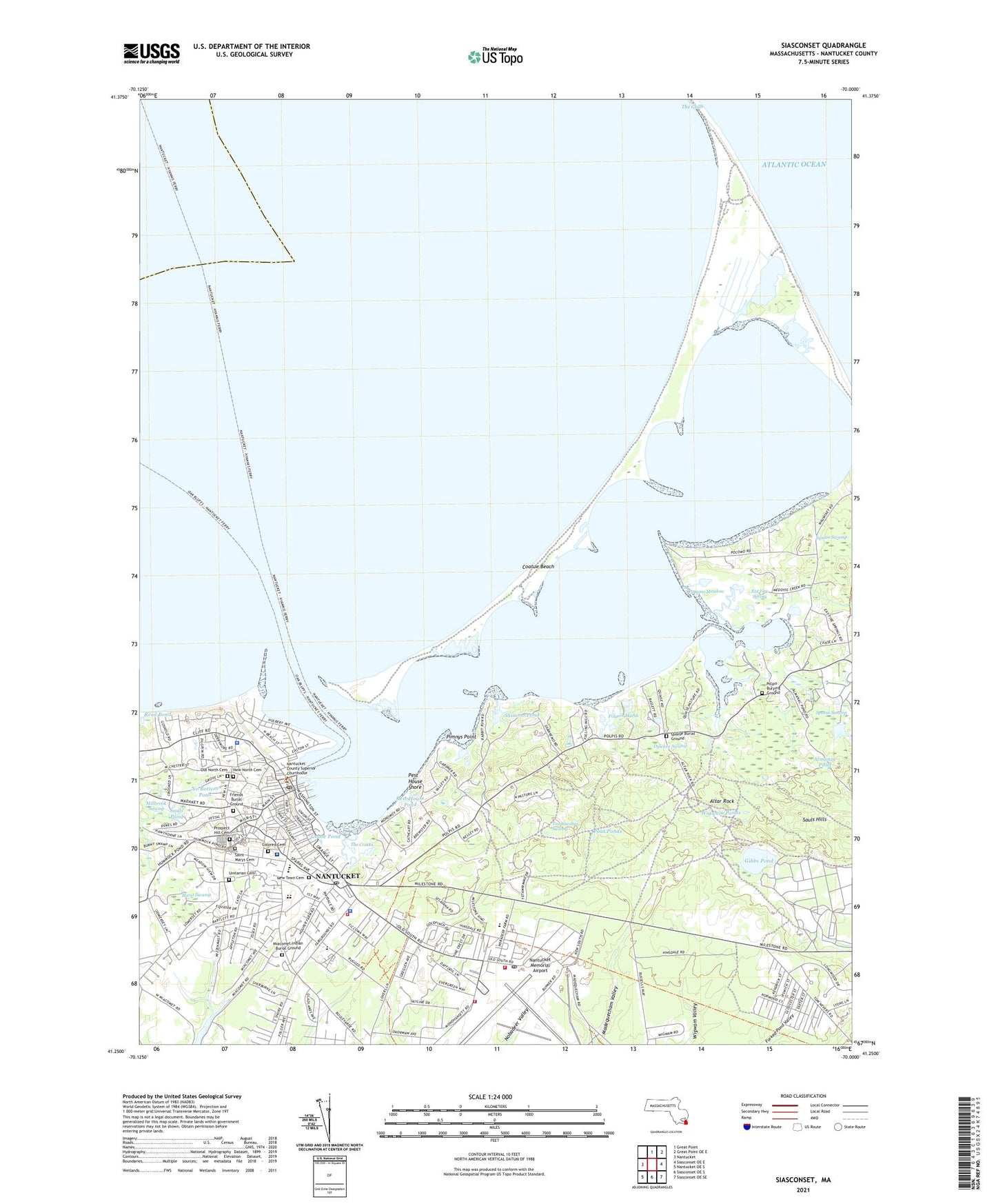
2021 topographic map quadrangle Siasconset in the state of Massachusetts. Scale: 1:24000. Based on the newly updated USGS 7.5' US Topo map series, this map is in the following counties: Nantucket. The map contains contour data, water features, and other items you are used to seeing on USGS maps, but also has updated roads and other features. This is the next generation of topographic maps. Printed on high-quality waterproof paper with UV fade-resistant inks.
Quads adjacent to this one:
West: Nantucket
North: Great Point
Northeast: Great Point OE E
East: Siasconset OE E
Southeast: Siasconset OE SE
South: Siasconset OE S
Southwest: Nantucket OE S
Contains the following named places: Abiah Folger Franklin Fountain, Abnecotants Island, Abrams Creek, Abrams Point, Academy Hill Housing, Academy Hill School, African Baptist Cemetery, Almanac Pond, Altar Rock, Bass Point, Brant Point, Brant Point Light, Brant Point Racquet Club, Burnt Swamp, Catos Pond, Childrens Beach, Clean Shore, Cliff Beach, Coatue, Coatue Beach, Coatue Point, Coatue-Coskata Wildlife Refuge, Colored Cemetery, Commercial Wharf, Congregation Shirat Ha Yam, Coskata, Coskata Beach, Coskata Pond, Cosuata, Cyrus Peirce Middle School, Dyleave Swamp, Eat Fire Spring, Fair Street Museum, First Baptist Church, First Church of Christ Scientist, First Congregational Church, First Point, Five Fingered Point, Folger Hill, Folgers Marsh, Friends Burial Ground, Friends Meeting House, Fudge Hill, Fulling Mill Creek, Gibbs Pond, Gibbs Swamp, Goose Pond, Greater Light, Greater Light Garden, Hadwen and Barney Candle Factory, Hadwen House-Salter Memorial, Head of the Harbor, Hinchman House, Island Creek, Jethro Coffin House Museum, Jetties Beach, Jetties Beach Public Tennis Courts, Kingdom Hall of Jehovahs Witnesses, Landmark House, Lily Pond, Lily Pond Park, Loines Observatory, Main Street Square, Maria Mitchell Aquarium, Maria Mitchell Association Natural Science Museum, Maria Mitchell Observatory, Maria Mitchell Science Library, Massachusetts State Police Station D6 Nantucket Barracks, Miacomet Golf Course, Miacomet Indian Burial Ground, Middle Pasture, Mikas Pond, Mill Hill Park, Millbrook Creek, Millbrook Swamp, Monomoy, Museum of Nantucket History, Nantucket, Nantucket Aero Light, Nantucket Atheneum, Nantucket Carrier Annex Post Office, Nantucket Census Designated Place, Nantucket Chamber of Commerce, Nantucket Cliffs, Nantucket Community-School Pool, Nantucket Cottage Hospital, Nantucket County Sheriff's Department, Nantucket East Breakwater Light, Nantucket Elementary School, Nantucket Ferry Slip Light, Nantucket Fire Department Headquarters Station 1, Nantucket Fire Station, Nantucket Harbor, Nantucket Harbor Range Light, Nantucket High School, Nantucket Historic District, Nantucket Historical Association, Nantucket Historical Association Library, Nantucket Island, Nantucket Life Saving Museum, Nantucket Maria Mitchell Association, Nantucket Memorial Airport, Nantucket New School, Nantucket Police Department, Nantucket Post Office, Nantucket Shipyard, Nantucket Station 1 Post Office, Nantucket Town Adminstration Building, Nantucket Town Pier, Nantucket United Methodist Church, Nantucket Visitor Services and Information Bureau, Nantucket Whaling Museum, Nantucket Worship Center, Nantucket Yacht Club, Nathaniel Macy House, New North Cemetery, New Town Cemetery, No Bottom Pond, Nobadeer Pond, North Pasture, Old Brant Point Lighthouse, Old Fire Cart House, Old Gaol, Old Mill, Old North Cemetery, Old North Wharf, Old South Wharf, Old Town Cemetery, Our Island Home, Pest House Pond, Pest House Shore, Peter Foulger Museum, Pimnys Point, Pocomo, Pocomo Head, Pocomo Meadow, Polpis, Polpis Burying Ground, Polpis Harbor, Popsquatchet Hills, Pout Ponds, Poverty Point, Prospect Hill Cemetery, Quaise, Quaise Burial Ground, Quaise Point, Reed Pond, Rest House Pond, Saint Marys Cemetery, Saint Marys Our Lady of the Isle Roman Catholic Church, Saint Pauls Episcopal Church, Sauls Hills, Sauls Pond, Second Point, Shawkemo, Shawkemo Hills, Sherburne Hall, Shimmo, Shimmo Creek, Shimmo Pond, Sir Issac Coffin School, Smugs Ria, Snake Spring, Society of Friends Church, Soldier and Sailors Monument, Somerset Airfield, South Beach, South Pasture, Spotsa Swamp, Squam Swamp, Steamboat Wharf, Steamship Authority Ferry, Stony Brook, Straight Wharf, Sunset Hill, Swains Neck, Taupawshas Swamp, The Creeks, The Galls, The Glades, The Homestead, The Pacific Club, The Three Bricks, Third Point, Thomas Macy Warehouse, Town of Nantucket, Town Pasture, Two Greeks, Unitarian Cemetery, Unitarian Universalist Church, University of Massachusetts Research Center, Wannacomet, Watts Run, Whale Rock, Wigwam Ponds, William Rotch Market, Wyers Point, ZIP Codes: 02554, 02584