MyTopo
Dearborn Michigan US Topo Map
Couldn't load pickup availability
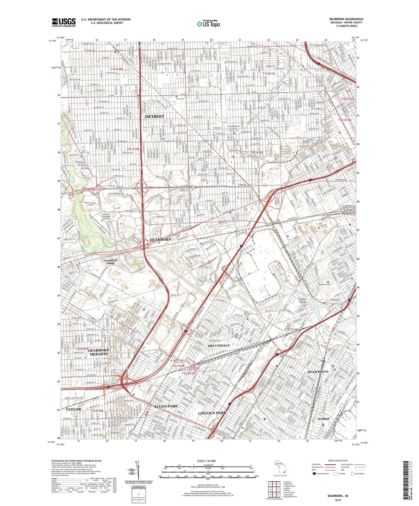
2019 topographic map quadrangle Dearborn in the state of Michigan. Scale: 1:24000. Based on the newly updated USGS 7.5' US Topo map series, this map is in the following counties: Wayne. The map contains contour data, water features, and other items you are used to seeing on USGS maps, but also has updated roads and other features. This is the next generation of topographic maps. Printed on high-quality waterproof paper with UV fade-resistant inks.
Quads adjacent to this one:
West: Inkster
Northwest: Redford
North: Royal Oak
Northeast: Highland Park
East: Detroit
Southeast: Wyandotte OE E
South: Wyandotte
Southwest: Flat Rock NE
Contains the following named places: Aaron Greeley-Saint Cosme Line Road Historical Marker, Adams Junior High School, Ahrens Field, Allen Drain, Allen Park, Allen Park Junior High School, Annapolis High School, Anthony Park, Arno School, Baby Creek, Barton School, Beaumont Hospital Dearborn, Bedford School, Bennett School, Bolles School, Boynton School, Brand Park, Bridgeview Park, Brooks Junior High School, Carver School, Chadsey High School, City of Allen Park, City of Dearborn, City of Melvindale, Clipper School, Cody High School, Colonial Homes and Adjacent Buildings Historical Marker, Community Jaycee Park, Coogan Park, Coolidge School, Cunningham Park, Dasher School, De Luca Field, Dearborn, Dearborn Amtrak Station, Dearborn City Hall Complex Historical Marker, Dearborn Helistop, Dearborn Inn Historical Marker, Dixon School, Doan Playground, Dover Park, Dunn School, Ecorse High School, Ecorse School Number 2, Edison Junior High School, Edsel Ford High School, Epiphany School, Everett School, Evergreen Cemetery, Fair Lane Manor Historical Marker, Fairlane Meadows Shopping Center, Fairlane North Shopping Center, Fairlane Plaza Heliport, Fairlane Town Center Shopping Center, Farmer Jack Shopping Center, Finlay School, Fisher School, Fitzpatrick Playground, Ford Airport Historical Marker, Ford Cemetery, Ford Field, Ford Hunger March Historical Marker, Ford Rogue Plant Historical Marker, Ford School, Ford Tri-Motor Historical Marker, Ford Woods Park, Fordson High School, Fordson High School Historical Marker, Fordson Island, Forman Playground, Gardner School, Geer Park, German Drain, Green Playground, Greenfield Village, Hanneman School, Harold G Cross Park, Hemlock Park, Henry Ford Birthplace Historical Marker, Henry Ford College, Henry Ford Community College, Henry Ford School, Herman School, Higgins School, Holmes School, Holy Cross Cemetery, Horger School, Howe School, Hunter School, Hyatt Regency Hotel Heliport, Jeffries School, John Bilak Park, John F Kennedy Park, John F Kennedy School, John Riel Memorial Park, Kaier School, Keidan School, King Boring Park, Kosciusko School, Lafayette School, Lankford Park, Lapeer Park, Lapham School, Leslie School, Lessenger Junior High School, Lincoln Park, Lincoln Park Greyhound Station, Lincoln Park Post Office Historical Marker, Lincoln Park Shopping Center Shopping Center, Lloyd H Ryan Playground, Loverix Park, Lower River Rouge, Lowrey School, Lutheran West High School, Lyster School, Mackenzie High School, Mann School, Maple School, Mark Twain School, Martin School, Mayfair School, McColl School, McDonald School, McFarlane School, McGinty Playground, McKerrow School, Mead School, Melvindale, Memorial Park, Michigan-Schaefer Shopping Center, Middle River Rouge, Miller School, Mount Hope School, Munger School, Nardin Park, Nativity School, Oakman School, Oakwood Downriver Medical Center, Orville L Hubbard Historical Marker, Our Lady of Heaven School, Our Lady of Lourdes School, Palmer School, Papalas Park, Parker School, Parkman School, Pattengill School, Patton Memorial Park, Paul Costea Park, Piwok Park, Plymouth Square Shopping Center, Polk School, Priest School, Quandt Park, Quandt School, Raupp School, Reeck Drain, Reves - Wilhelm Cemetery, Reves-Wilhelm Cemetery Historical Marker, River Oaks School, River Oaks Square Shopping Center, River Rouge, River Rouge Park, Robert School, Roger School, Rosary High School, Rosedale Park, Roulo School, Ruddiman High School, Ruthruff School, Saint Alphonsus Catholic Church Cemetery, Saint Alphonsus Catholic Church Complex Historical Marker, Saint Alphonsus Parish Historical Marker, Saint Alphonsus School, Saint Andrews School, Saint Barbaras School, Saint Bernadette School, Saint Cecilia School, Saint Christopher School, Saint Clement School, Saint Cunegundis School, Saint Cyril of Jerusalem School, Saint Gabriel Academy, Saint Henry School, Saint Lawrence School, Saint Luke School, Saint Mary School, Saint Matthews School, Saint Sebastian School, Saint Stephanus School, Saint Stephens School, Saint Suzanne School, Saint Thomas Aquinas School, Saints Andrew and Benedict School, Saints Peter and Paul School, Salina School, Sherrill School, Snow School, Stein Playground, Stoepel Park Number 2, Strong Junior High School, Strout Junior High School, Sudman School, Tappan School, Taylor Commons Shopping Center, Taylor Park School, Ten Eyck School, Thayer School, The Edison Institute Historical Marker, Tournament Players Club of Michigan, Tyre Drain, Unis Middle School, University of Michigan - Dearborn, Vibra Hospital of Southeastern Michigan, Visger School, Vista Maria School, Warrendale Charter Academy, Weatherby School, Weiss Playground, WHFR-FM (Dearborn), White School, Wilson Playground, Woodmere Cemetery, Woodmere Station, Woodworth School, ZIP Codes: 48101, 48120, 48122, 48124, 48126, 48204, 48210, 48217, 48218, 48228, 48229