MyTopo
Crosby Minnesota US Topo Map
Couldn't load pickup availability
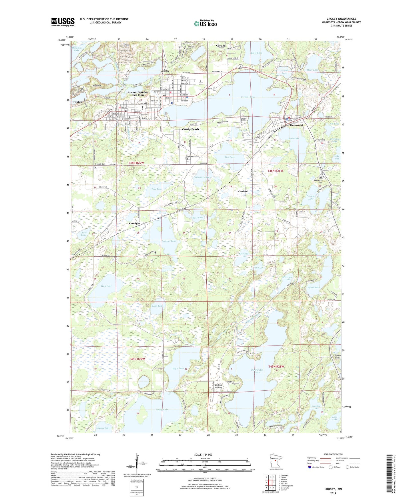
2019 topographic map quadrangle Crosby in the state of Minnesota. Scale: 1:24000. Based on the newly updated USGS 7.5' US Topo map series, this map is in the following counties: Crow Wing. The map contains contour data, water features, and other items you are used to seeing on USGS maps, but also has updated roads and other features. This is the next generation of topographic maps. Printed on high-quality waterproof paper with UV fade-resistant inks.
Quads adjacent to this one:
West: Riverton
Northwest: Trommald
North: Cuyuna
Northeast: Iron Hub
East: Bay Lake
Southeast: Garrison
South: Grave Lake
Southwest: South Long Lake
Contains the following named places: Agate Lake, Armour Number Two Mine, Assemblies of God Church, Assemblies of God Tabernacle Church, Bible Baptist Church, Black Lake, Cascade Lake, Cascade United Methodist Church, Cayuna Range Historical Marker, Central High School, Central Lakes Medical Center, City of Crosby, City of Deerwood, City of Ironton, Clearwater Lake, Clearwater Lake Dam, Crato Lake, Croft Mine, Croft Mine Historical Park, Crosby, Crosby Beach, Crosby City Hall, Crosby Police Department, Crosby Post Office, Crosby Presbyterian Church, Crosby Railroad Station, Crosby Volunteer Fire Department, Cuyuna Country Club, Cuyuna Range Elementary School, Cuyuna Regional Medical Center, Deerwood, Deerwood Baptist Church, Deerwood Cemetery, Deerwood City Hall, Deerwood Mobile Home Park, Deerwood Police Department, Deerwood Post Office, Deerwood Volunteer Fire Department, Eagle Lake, Feigh Mine, Franklin Park, Franklin School, Hawthorne Dam, Heartland Sports Complex, Hopkins Mine, Immanuel Lutheran Church, Indian Point, Ironton, Ironton City Hall, Ironton Fire Department, Ironton Post Office, Ironton School, Jessie F Hallett Library, Jim Lake, Joan Mine, Klondike Post Office, Klondyke, Lake Ann, Lakewood Cemetery, Lighthouse Community Church, Lindey's Landing, Lookout Lake, Loon Lake, Louise Mine, Mahnomen Number One Mine, Mahnomen Number Three Mine, Mals-Serpent Lake Seaplane Base, Manuel Mine, Menomin Lake, Nokay Lake, Olander Lake, Oreland, Oreland Lake, Oreland Post Office, Pennington Mine, Peterson Lake, Placid Lake, Portage Lake, Portsmouth Bay Campground, Portsmouth Mine, Portsmouth Mine Geological Marker, Range Historical Society Museum, Reno Lake, Reorganized Church of Jesus Christ of Latter-Day Saints, Rice Lake, Rose Lake, Saint Joseph Catholic Church, Saint Joseph Church, Saint Josephs School, Salem Lutheran Church, Serpent Creek, Serpent Lake, Serpent Lake Mobile Home Park, Towns Edge Mobile Home Park, United Methodist Church, Vang Lake, Wayside Park, Wolf Lake, Woodland Cemetery, Zion Lutheran Church, ZIP Code: 56444