MyTopo
Yellow Creek Mississippi US Topo Map
Couldn't load pickup availability
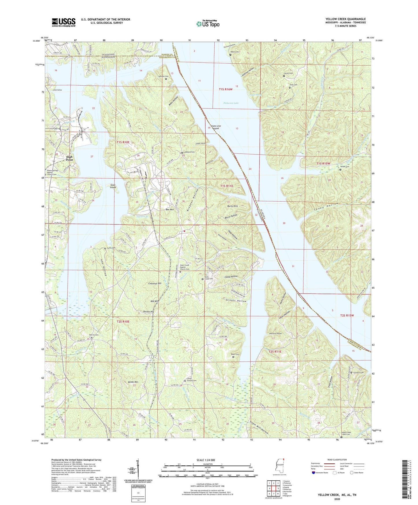
2020 topographic map quadrangle Yellow Creek in the states of Mississippi, Alabama, Tennessee. Scale: 1:24000. Based on the newly updated USGS 7.5' US Topo map series, this map is in the following counties: Tishomingo, Lauderdale, Hardin. The map contains contour data, water features, and other items you are used to seeing on USGS maps, but also has updated roads and other features. This is the next generation of topographic maps. Printed on high-quality waterproof paper with UV fade-resistant inks.
Quads adjacent to this one:
West: Doskie
Northwest: Counce
North: Pickwick
Northeast: Lowryville
East: Waterloo
Southeast: Margerum
South: Iuka
Southwest: Burnsville
Contains the following named places: Ada Hollow, Arnold Branch, Baugh Creek, Baughs Landing, Beall Cemetery, Beckham Landing, Bee Mountain, Blackard Hollow, Bonds Mountain, Boo Hollow, Brogdan Hollow, Bugg Landing, Bullard Branch, Bullard School, Burns Hills, Burns Hollow, Burns Landing, Busbys Landing, Camp Ground Cemetery, Camp Ground Church, Camp Hollow, Camp Hollow Creek, Caney Hollow, Carson Cemetery, Cedar Fork, Chalk Hollow, Charlie Branch, Chestnut Hill, Clement Cemetery, Colman Park Fire Department, Cooks Landing, Cooper Hollow, Curtis Cemetery, Dixon Hollow, Evans Landing, Ferry Bridge, Fred Hollow, Glade Branch, Goat Island, Goat Island Marina, Goat Island Recreation Area, Greenwater Marina, Haddock, Haddock Post Office, Hamptons Mill, Hard Times Landing, Hicks Hollow, High Point, Hitchcock Branch, Hitchcock Hollow, Hitchcock Landing, Hubbard Branch, Hubbard Cemetery, Hubbard Landing, Huffman Branch, Huffman Hollow, Hurricane Branch, Indian Creek, Iuka Landing, J P Coleman State Park, Johnny Creek, Johnny Hollow, Johnny Landing, Johnson Cemetery, Kreamer Branch, Lard Branch, Lauderdale State Wildlife Management Area, Martin Branch, Mawres Landing, Meat Hollow, Middle Mountain, Morgan Branch, North Fork Panther Creek, Owens Hollow, Panther Creek, Panther Creek School, Parker Cemetery, Parker Landing, Patrick Cemetery, Patrick Church, Patrick School, Poplar Spring, Poplar Springs Baptist Church Cemetery, Poplar Springs School, Popular Springs Church, Popular Springs School, Potato Hill, Prairie, Red Sulphur Springs Branch, Red Sulphur Springs Cabin Area, Robinson Landing, Salem Church, Scruggs Branch, Scruggs Bridge Overlook Area, Shaw, Shaw Branch, Shaw Cemetery, Shaw Hollow, Shaw Landing, Shop Hollow, Short, Short Creek, Short Creek Cemetery, Short Creek School, Slick Rock Branch, Smith Branch, Smith Hollow, Smith Landing, South Fork Panther Creek, State Line Cabin Area, State Line Ferry, State Line Island, Steam Mill Hollow, Stinett Hollow, Supervisor District 1, Tackett Branch, Tanyard Branch, Thomas Landing, Tylers Landing, Union Hollow, Walker School, Wates Cemetery, Whetstone Branch, Yellow Creek, Yellow Creek Cabin Area, Yellow Creek Nuclear Power Plant, Yellow Creek State Inland Port, Zippy Branch