MyTopo
Oakville Missouri US Topo Map
Couldn't load pickup availability
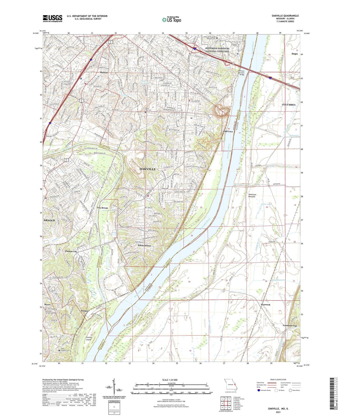
2021 topographic map quadrangle Oakville in the states of Missouri, Illinois. Scale: 1:24000. Based on the newly updated USGS 7.5' US Topo map series, this map is in the following counties: St. Louis, Monroe, Jefferson. The map contains contour data, water features, and other items you are used to seeing on USGS maps, but also has updated roads and other features. This is the next generation of topographic maps. Printed on high-quality waterproof paper with UV fade-resistant inks.
Quads adjacent to this one:
West: Maxville
Northwest: Kirkwood
North: Webster Groves
Northeast: Cahokia
East: Columbia
Southeast: Waterloo
South: Valmeyer
Southwest: Herculaneum
Contains the following named places: Abiding Savior Lutheran School, Apostolic Faith Church, Arnold Church, Arnold City Park, Arnold Park, Arnold Post Office, Arrowhead Golf Course, Assembly of God South Side Church, Beasley Elementary School, Bee Tree County Park, Bee Tree Lake Dam, Bernard Middle School, Blades Elementary School, Butler Hill Church, Butler Hill Plaza, Butler Hill Village Shopping Center, Byers, Calvary Church, Canaan Baptist Church, Carr Creek, Chesley Island, Childrens World Learning Center at Baumgarten, Church of Jesus Christ of Latter Day Saints, Church of Oakville, City of Arnold, Cliff Cave, Cliff Cave County Park, Cross of Christ Church, Don Earl Early Childhood Center, Election Precinct 10, Etter School, Faith Church, First Baptist Church of Oakville, First Unity Church of Saint Louis, Flamm City, Flamm City Public Access, Fordyce House, Forever Living Church of God, Fountain Gap, Fountain Temple Church of God in Christ, Foursquare Church, Fox Elementary School, Fox Middle School, Fox School, Fox Senior High School, Good Shepard Church, Grace Freewill Church, Heartland Baptist Church, Hill Lake Creek, Hillcrest Country Club, Howe Lake, James J Rickman Auditorium, Jefferson Barracks Bridge, Jefferson Barracks National Cemetery, Jefferson College North, Keller Plaza Shopping Center, Kendall, Kingdom Hall, Kise Crossing, Koch, Koch Hospital, Lake of the Woods, Lakeside, Le May, Lighthouse Church, Little Carr Creek, Martigney Creek, Mary Mother of the Church Parish Hall, Mattese, Mattese Church, Mattese Creek, Mattiese Shopping Center, Mehlville, Mehlville Fire Protection District Engine House Number 2, Mehlville Fire Protection District Station 6, Mehlville Fire Protection District Station 7, Memorial Chapel, Meramec River, Monastery of Saint Clare, Nazareth Convent, Oakville, Oakville Census Designated Place, Oakville Elementary School, Oakville High School, Oakville Junior High School, Oakville School, Oakville Shopping Center, Palmer Creek, Peace Church, Planet Child Care Center of Oakville, Point, Point Elementary School, Point School, Pomme Creek, Porter Lake, Prince of Peace United Church of Christ, Queen of All Saints Church, Queen of All Saints School, Radiant Love Church, Real Life Church, Riverview School, Rogers Elementary School, Ronquest Field, Royal Forest Park, Saint David School, Saint Francis Convent, Saint Francis of Assisi Church, Saint Francis of Assisi School, Saint Josephs Cemetery, Saint Margaret Mary Alacoque Church, Saint Margaret Mary Alacoque School, Saint Paul Cemetery, Saint Paul Church, Saunders Lake, Soulard School, South Country Church, South County Christian Center, South County Church of the Nazarene, South County Post Office, South Telegraph Church, Southside Church, Starling Road Church, Sugar Creek, Telegraph Plaza Shopping Center, Ten Brook, Township of Arnold, Township of Oakville, Trautwein Elementary School, Veterans Affairs Saint Louis Medical Center - Jefferson Barracks Division, Waddle Lake, Warnock, Washington Middle School, Washington School, Watertower Place Shopping Center, White House, Wickes, Wohlwend Elementary School, Wohlwend School, Zion Church, ZIP Code: 63129