MyTopo
East Bay Montana US Topo Map
Couldn't load pickup availability
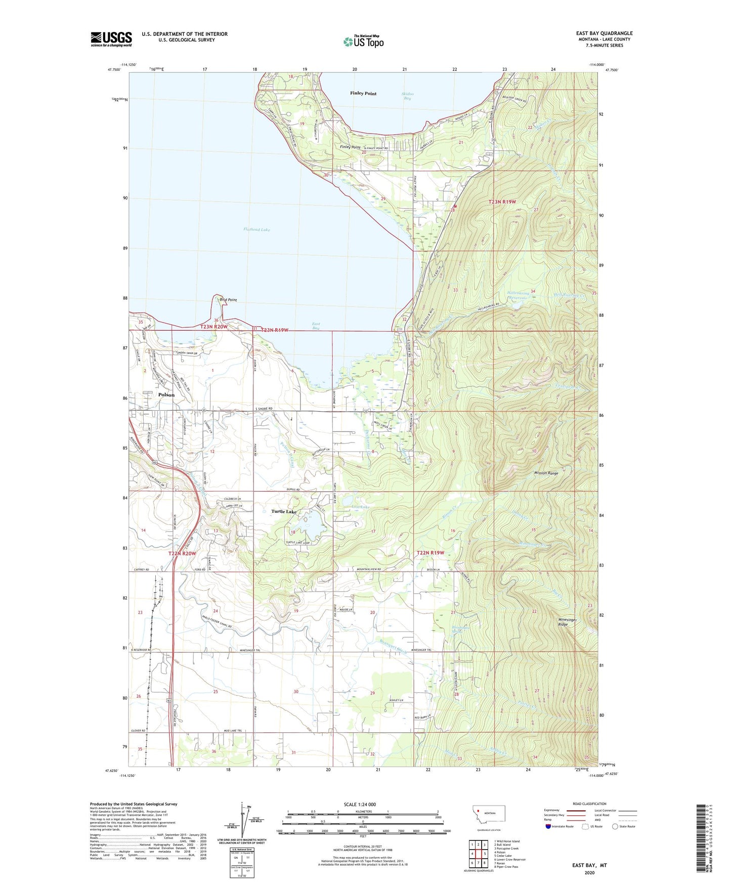
2020 topographic map quadrangle East Bay in the state of Montana. Scale: 1:24000. Based on the newly updated USGS 7.5' US Topo map series, this map is in the following counties: Lake. The map contains contour data, water features, and other items you are used to seeing on USGS maps, but also has updated roads and other features. This is the next generation of topographic maps. Printed on high-quality waterproof paper with UV fade-resistant inks.
Quads adjacent to this one:
West: Polson
Northwest: Wild Horse Island
North: Bull Island
Northeast: Porcupine Creek
East: Cedar Lake
Southeast: Piper-Crow Pass
South: Ronan
Southwest: Lower Crow Reservoir
Contains the following named places: 22N19W04CCCC01 Well, 22N19W05CCA_01 Well, 22N19W08AAB_01 Well, 22N19W09BCB_01 Well, 22N19W17CBA_01 Well, 22N19W18DAA_01 Well, 22N19W20ADAA01 Well, 22N19W20ADAA02 Well, 22N19W20BBDD01 Well, 22N19W29CBC_01 Well, 22N19W32BCDD01 Well, 22N19W33BBBD01 Well, 22N20W11CADB01 Well, 22N20W12CCC_01 Well, 22N20W13ADDD01 Well, 22N20W14DDC_01 Well, 22N20W23DAD_01 Well, 22N20W24CDD_01 Well, 22N20W25ABA_01 Well, 22N20W25BABD01 Well, 23N19W15CCA_01 Well, 23N19W15CCC_01 Well, 23N19W19ADB_01 Well, 23N19W28BCC_01 Well, 23N19W29ADAD01 Well, Allard, Ashley Creek, Big Creek, Bird Point, Bisson Creek, Blumhagen Spring, Bousquet Ditch, Centipede Creek, Dubay Creek, Ducharme Creek, Ducharme Fishing Access Site, Dupuis, Eagle Nest RV Resort, East Bay, Finley Point, Finley Point - Yellow Bay Volunteer Fire Department, Finley Point Census Designated Place, First Baptist Church, Flathead Lake RV Resort and Campground, Fletcher, Hell Roaring Creek, Hellroaring Dam, Hellroaring Reservoir, Holmes Creek, Jehovahs Witnesses, KERR-AM (Polson), Lake County, Lost Lake, Minesinger Creek, Miracle of America Museum and Pioneer Village, Moss Creek, Mountain View, Mountain View School, Peaceful Haven Mobile Home Park, Poirier Creek, Polson A Canal, Polson D Canal, Polson Foursquare Church, Polson Z Canal, Reclamation, Rocking C Ranch, Skidoo Creek, Turtle Lake, Turtle Lake Census Designated Place, Twin Dam