MyTopo
Hash Mountain Montana US Topo Map
Couldn't load pickup availability
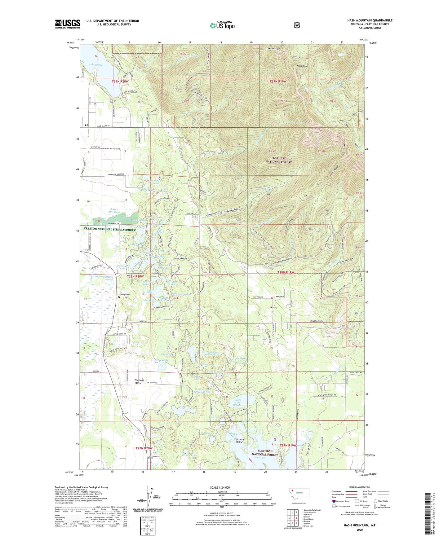
2020 topographic map quadrangle Hash Mountain in the state of Montana. Scale: 1:24000. Based on the newly updated USGS 7.5' US Topo map series, this map is in the following counties: Flathead. The map contains contour data, water features, and other items you are used to seeing on USGS maps, but also has updated roads and other features. This is the next generation of topographic maps. Printed on high-quality waterproof paper with UV fade-resistant inks.
Quads adjacent to this one:
West: Creston
Northwest: Columbia Falls South
North: Doris Mountain
Northeast: Nyack SW
East: Jewel Basin
Southeast: Crater Lake
South: Bigfork
Southwest: Somers
Contains the following named places: 27N19W04CADD01 Well, 27N20W02AB__01 Well, 27N20W02CC__01 Well, 27N20W03AB__01 Well, 27N20W03DC__01 Well, 28N19W07CC__01 Well, 28N19W20DCAA01 Well, 28N20W01BA__01 Well, 28N20W02AB__01 Well, 28N20W02BB__01 Well, 28N20W03AB__01 Well, 28N20W03DD__01 Well, 28N20W03DD__02 Well, 28N20W10AD__01 Well, 28N20W10DC__01 Well, 28N20W10DD__01 Well, 28N20W10DD__02 Well, 28N20W11AC__01 Well, 28N20W11CB__01 Well, 28N20W11CCBC01 Well, 28N20W14ACDA01 Well, 28N20W14CCBC01 Well, 28N20W14CCCB01 Well, 28N20W14CCCB02 Well, 28N20W14CCCC01 Well, 28N20W14CCCC02 Well, 28N20W14CCCC03 Well, 28N20W14CCCC04 Well, 28N20W14CCCD01 Well, 28N20W14CCCD02 Well, 28N20W14CCDA01 Well, 28N20W14CCDA02 Well, 28N20W14CCDB01 Well, 28N20W14CCDD01 Well, 28N20W14CDCC01 Well, 28N20W14CDDC01 Well, 28N20W15AB__01 Well, 28N20W15AD__01 Well, 28N20W15DB__01 Well, 28N20W22AAAB01 Well, 28N20W23BA__01 Well, 28N20W23BABC01 Spring, 28N20W23CA__01 Well, 28N20W25DC__01 Well, 28N20W26BAAA01 Well, 28N20W26BB__01 Well, 28N20W27DD__01 Well, 28N20W34AA__01 Well, 28N20W35AA__01 Well, 29N20W35CD__02 Well, 29N20W35DD__01 Well, 29N20W35DD__02 Well, 29N20W36BAAB01 Well, 29N20W36CD__01 Well, 29N20W36DC__01 Well, 29N21W02AA__01 Well, Alpine Trail, Amy Lake, Angel Lake, Ann Lake, Baines, Basham Lake, Blackies Bay, Blue Lake, Boys Lake, Brander, Brown Creek, Brown Gulch, Cabin Lake, Cayuse Prairie School, Circle Lake, Cougar Lake, Cree Lake, Creston Cemetery, Creston Church, Creston Fire Department Mountain Brook Station, Creston National Fish Hatchery, Creston Rural Fire District, Dan Lake, Double Lake, Dry Lake, East Bass Lake, Echo Creek, Echo Lake, Echo Post Office, Echo School, Elsecon, Evans, Firemens Island, Garlick Lake, Gilbert Lake, Grayling Lake Number One, Grayling Lake Number Two, Handkerchief Creek, Harbin Lake, Hash Mountain, Hemler Creek, Isaac, Jessup Mill Pond, Jessup Mill Pond Dam, John Lake, Kathy Lake, Kaufmans Lake, Kid Lake, Kohler Lake, Krause Creek, Lake Blaine, Lake Blaine Resort Campground, Lake Douglas, Lake Meredith, Lake of the Woods, Lake Peter, Lamoose Lake, McGilvray Lake, Mountain Brook School, Noisy Creek, Northwest Montana Fishery Center, Olive Lake, Olson Creek, Peters Creek, Peters Ridge, Plummers Lake, Portor, Pratt Lake, Sawdust Lake, South Fork Hemler Creek, Spill Lake, Swimming Lake, Talmadge Lake, Tamarack Lake, Trail Creek