MyTopo
Omaha North Nebraska US Topo Map
Couldn't load pickup availability
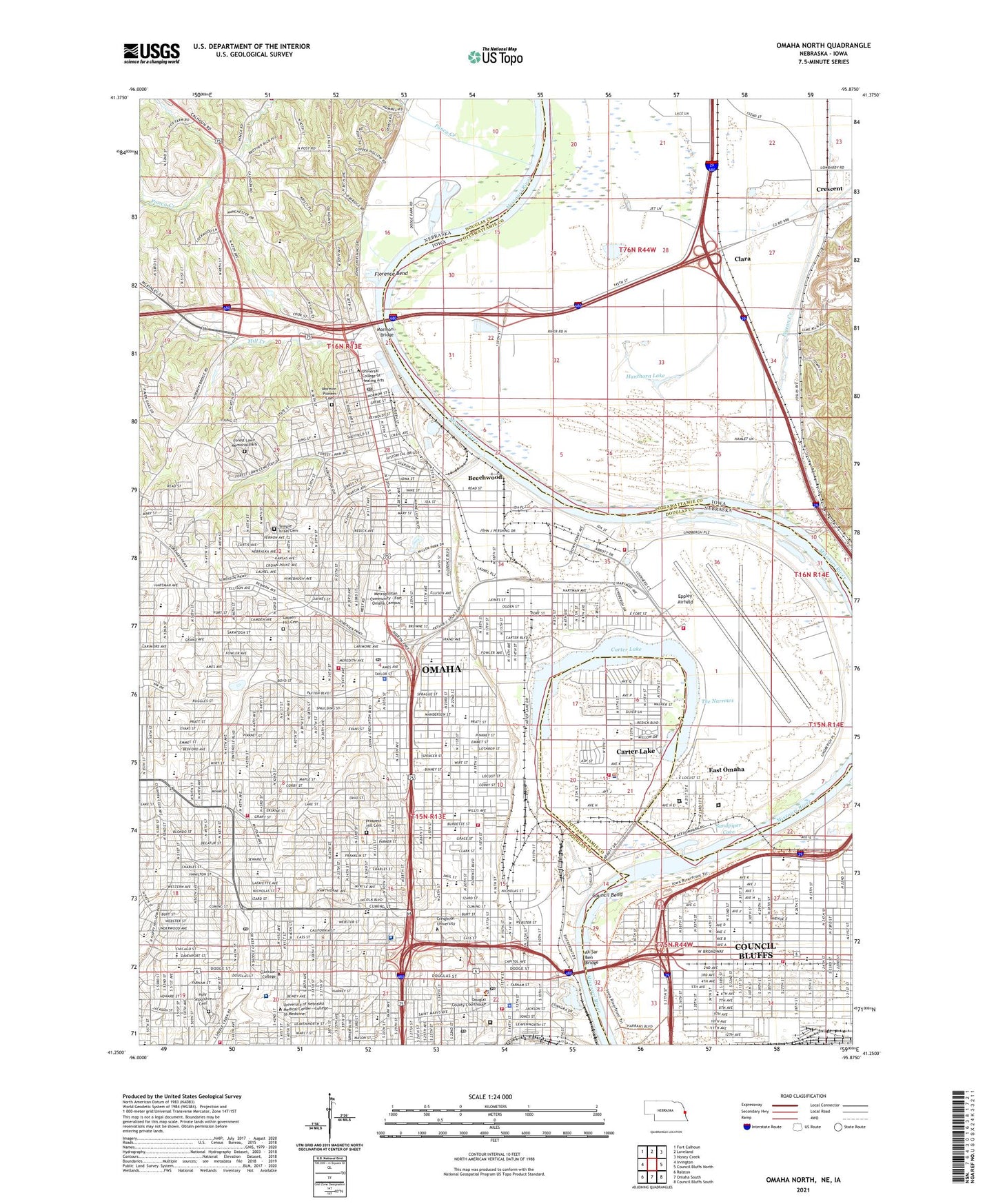
2021 topographic map quadrangle Omaha North in the states of Nebraska, Iowa. Scale: 1:24000. Based on the newly updated USGS 7.5' US Topo map series, this map is in the following counties: Douglas, Pottawattamie. The map contains contour data, water features, and other items you are used to seeing on USGS maps, but also has updated roads and other features. This is the next generation of topographic maps. Printed on high-quality waterproof paper with UV fade-resistant inks.
Quads adjacent to this one:
West: Irvington
Northwest: Fort Calhoun
North: Loveland
Northeast: Honey Creek
East: Council Bluffs North
Southeast: Council Bluffs South
South: Omaha South
Southwest: Ralston
Contains the following named places: A Station, Adams Park, Ahmanson Law School, Ak Sar Ben Bridge, Alegent Health Clinic, Ames Avenue Post Office, Associate Dentists Center, Avenue B School, B Station, Bank of Florence Historical Marker, Bedford Place Park, Beechwood, Belvedere Elementary School, Bemis Park, Benson Magnet High School, Bluff View Park, Bluffs Family Health Care Center, Boys Town National Research Hospital, Broadway Family Dentistry Center, Brownell Hall, Brownell Talbot Schools, Burdette Park, Capitol Hill Historical Marker, Career Center, Carter Lake, Carter Lake Elementary School, Central High School, Central High School Historical Marker, Central Park Elementary School, Central Park Mall, Charles Drew Health Center, Childrens Urgent Care Center, City of Carter Lake, Clara, Clarkson College, Clarkson Hospital, Clarkson Primary Care Center, Clifton Hill School, Cochran Park, Colonial Acres Park, Conestoga Magnet Elementary School, Council Bend, Council Bluffs Levee Unit, Council Bluffs Water Works, Creighton Family Healthcare Building - Florence, Creighton Family Healthcare Center, Creighton Medical Associates - Clinical Departments, Creighton University, Creighton University Historical Marker, Creighton University Medical Center, Crescent Quarry, Crook House Historical Marker, Crown Point Park, Deacoresd Institute, Dewey Park, Doctors Hospital, Dodge Park, Dodge Park Golf Course, Druid Hill Elementary School, Duchesne Academy Historical Marker, Duchesne Academy of the Sacred Heart, Dundee Elementary School, Durham Outpatient Center, Early Childhood Center at Yates, East Omaha, Edison Elementary School, Eppley Airfield, Erskine Park, Fairfax School, Filmore Park, Florence Bend, Florence Election Precinct, Florence Elementary School, Florence Heights Village, Florence Home, Florence Mill Historical Marker, Florence Park, Florence Post Office, Fontenelle Elementary School, Fontenelle Park, Forest Lawn Memorial Park, Forest Lawn Memorial Park Historical Marker, Fort Omaha Historical Marker, Franklin Elementary School, Freedom Park, Friendship Park, Gallagher Park, Garden Valley Courts, Gateway Vision Clinic, Gene Leahy Mall, Gifford Park, Golden Hill Cemetery, Golden Spike Monument, Graham Triangle Park, Hanthorn Lake, Harrison Elementary School, Heartland of America Park, Himebaugh Park, Historic Prospect Hill - Omahas Pioneer Cemetery Historical Marker, Holy Angels School, Holy Family School, Holy Name School, Holy Sepulchre Cemetery, Home Park, Hope School, Horace Mann School, Hoummel Park, J P Lord Elementary School, J P Lord School, Jackson Alternative Center, Jackson Elementary School, Jesuit Academy, Kellom Elementary School, Kellom Greenbelt Park, Kellom Park, Kenefick Park, Kennedy Elementary School, King Elementary School, King Science and Technology Magnet School, KIOS-FM (Omaha), Kountze Park, Lake James Park, Lake School, Lapworth Creek, Leavenworth Park, Levi Carter Park, Lewis and Clark Camp Site: July 27 1804 Historical Marker, Liberty Elementary School, Lied Transplant Center, Lindenwood Nursing Home, Logan Park, Long School, Lothrop Magnet Center, Lutheran Home, Magnet Career Center, Malcolm X Birthsite, Malcolm X Historical Marker, McMillan Magnet Middle School, Memorial Park, Mercer Park, Metcalfe Park, Metropolitan Community - Fort Omaha Campus, Miami Playground, Midtown Plaza, Mill Creek, Miller Park, Miller Park Elemetary School, Miller Park Golf Course, Minne Lusa Elementary School, Monmouth Park School, Monroe Middle School, Mormon Bridge, Mormon Pioneer Cemetery, Mount Calvary Lutheran Elementary School, Mount View Elementary School, Myott Park, Narrows River Access County Park, Nebraska School for the Deaf, Nelson Mandela Elementary School, Notre Dame Academy, NP Dodge Park Campground, Oak Grove Manor, Old Market, Omaha, Omaha Levee Unit, Omaha North Magnet High School, Overland Mobile Home Park, Park East, Parkfair Shopping Mall, Parrish School, Pershing Park, Pershing School, Pigeon Creek, Plastic Surgical Center PC, Playland Park, Ponca Creek, Ponderosa Village Mobile Home Park, Postal Emporium Post Office, Prime Time Medical Center for Men, Prospect Hill Cemetery, Richard H Young Memorial Hospital, Roberts Park, Rue Elementary School, Sacred Heart School, Saddle Creek Post Office, Saint Cecilia Cathedral School, Saint Joseph Academy, Saint Joseph Hospital Heliport, Saint Paul Lutheran School, Saint Pauls School, Saint Peter School, Saint Philip Neri School, Saint Richard Elementary School, Saint Therese School, Sandpiper Cove, Saratoga Elementary School, Saunders School, Sherman Elementary School, Skinner Magnet Center School, Spaulding Park, TD Ameritrade Park Omaha, Technical High School, Temple Israel Cemetery, The Narrows, The Nebraska Medical Center, The Paxton Center, Thirty-Second and Franklin Street Park, Thomas Jefferson High School, Township of Crescent, Trans-Mississippi and Inter Expo Historical Marker, Turner Park, Twenty-Eighth and Craig Street Park, Twenty-Second and Willis Street Park, Union Station, University Hospital, University of Nebraska Medical Center - College of Medicine, University of Nebraska Medical Center Heliport, Wakonda Elementary School, Walnut Grove Elementary School, Walnut Hill Elementary School, Walnut Hill Park, Westwood Golf Course, Westwood Park, William Henry Jackson Historical Marker, Winter Quarters Historical Marker, WOW-AM (Omaha), Yale Park, ZIP Codes: 51510, 68102, 68110, 68111, 68112, 68131, 68152, 68178