MyTopo
Newmarket New Hampshire US Topo Map
Couldn't load pickup availability
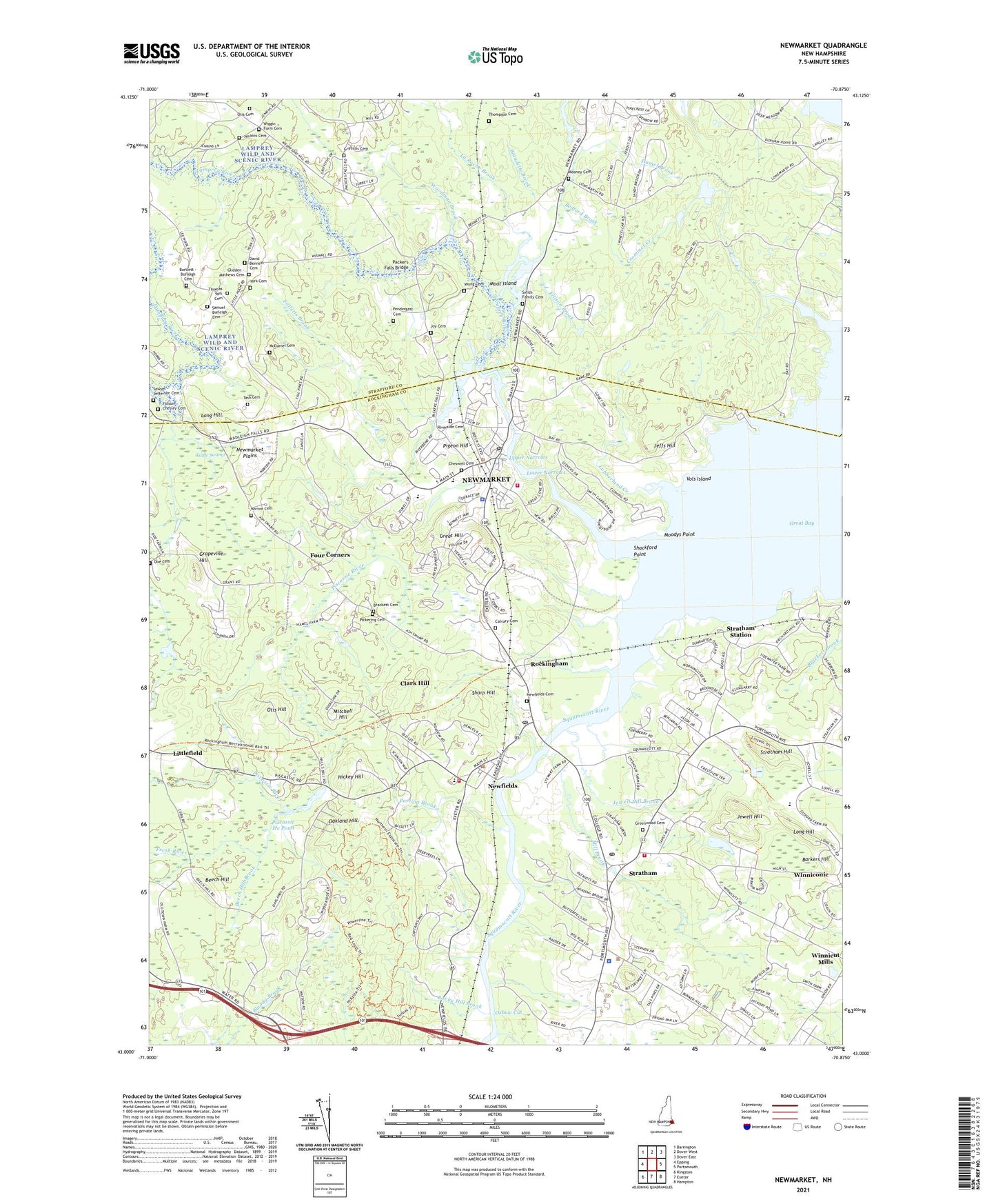
2021 topographic map quadrangle Newmarket in the state of New Hampshire. Scale: 1:24000. Based on the newly updated USGS 7.5' US Topo map series, this map is in the following counties: Rockingham, Strafford. The map contains contour data, water features, and other items you are used to seeing on USGS maps, but also has updated roads and other features. This is the next generation of topographic maps. Printed on high-quality waterproof paper with UV fade-resistant inks.
Quads adjacent to this one:
West: Epping
Northwest: Barrington
North: Dover West
Northeast: Dover East
East: Portsmouth
Southeast: Hampton
South: Exeter
Southwest: Kingston
Contains the following named places: Acorn School, Barkers Hill, Bartlett - Burleigh Cemetery, Beaudette Brook, Bedford Brook, Beech Hill, Beech Hill Brook, Brackett Cemetery, Calvary Cemetery, Cheswell Cemetery, Clark Hill, Cornerstone Baptist Church, Cornerstone Christian Academy, Crommet Creek, David Bennett Cemetery, Doe Cemetery, Ellison Brook, Folletts Brook, Folsom - Chesley Cemetery, Four Corners, Fresh River, Glidden - Mathews Cemetery, Grapevine Hill, Great Bay Kids Company Child Care Center, Great Hill, Greenwood Cemetery, Griffiths Cemetery, Hickey Hill, Jeffs Hill, Jenkins Cemetery, Jewell Hill, Jewell Hill Brook, Joy Cemetery, La Roche Brook, Lamprey River, Lamprey River Reservoir, Littlefield, Littlefield Railroad Station, Long Hill, Longmarsh Brook, Lower Narrows, Lubberland Creek, Macallen Dam, McDaniel Cemetery, Mill Brook, Mitchell Hill, Moat Island, Moodys Point, Mooney Cemetery, Moonlight Brook, New Fields Police Department, New Hampshire Community Technical College of Stratham, New Hampshire Technical College Learning Resources Center, New Market Congregational Church, Newfields, Newfields Cemetery, Newfields Census Designated Place, Newfields Community Church, Newfields Elementary School, Newfields Fire and Rescue, Newfields Post Office, Newmarket, Newmarket Census Designated Place, Newmarket Community Church, Newmarket Elementary Preschool, Newmarket Elementary School, Newmarket Fire and Rescue, Newmarket Industrial and Commercial Historic District, Newmarket Junior and Senior High School, Newmarket Plains, Newmarket Police Department, Newmarket Post Office, Newmarket Public Library, Newmarket Town Hall, Norton Cemetery, Oakland Hill, Otis Cemetery, Otis Hill, Oxbow Cut, Packers Falls, Packers Falls Bridge, Packers Falls Dam, Parting Brook, Pendergast Cemetery, Pickering Cemetery, Pigeon Hill, Piscassic Ice Pond, Piscassic River, Riverside Cemetery, Rockingham, Rockingham Country Club, Rocky Hill Brook, Samuel Burleigh Cemetery, Sawyer - Jefferson Cemetery, Shackford Point, Sharp Hill, Squamscott River, Stratham, Stratham Church, Stratham Elementary School, Stratham Fairgrounds, Stratham Hill, Stratham Memorial Elementary School, Stratham Memorial Preschool, Stratham Municipal Center, Stratham Police Department, Stratham Post Office, Stratham Station, Stratham Town Hall, Stratham Volunteer Fire Department, Tash Cemetery, Thomas York Cemetery, Thompson Cemetery, Town of Durham, Town of Newfields, Town of Newmarket, Town of Stratham, Tuttle Swamp, Upper Narrows, Vols Island, WERZ-FM (Exeter), Wiggin Memorial Library, Winniconic, Woodman Brook, York Cemetery, Young Cemetery, ZIP Codes: 03824, 03856, 03857, 03885