MyTopo
Portsmouth New Hampshire US Topo Map
Couldn't load pickup availability
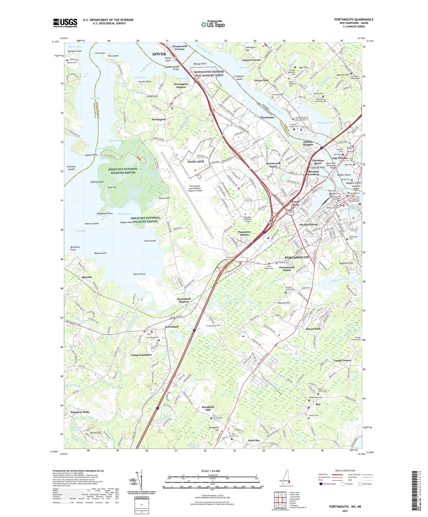
2021 topographic map quadrangle Portsmouth in the states of New Hampshire, Maine. Scale: 1:24000. Based on the newly updated USGS 7.5' US Topo map series, this map is in the following counties: Rockingham, York, Strafford. The map contains contour data, water features, and other items you are used to seeing on USGS maps, but also has updated roads and other features. This is the next generation of topographic maps. Printed on high-quality waterproof paper with UV fade-resistant inks.
Quads adjacent to this one:
West: Newmarket
Northwest: Dover West
North: Dover East
Northeast: York Harbor
East: Kittery
Southeast: Isles of Shoals OE W
South: Hampton
Southwest: Exeter
Contains the following named places: Abraham Shaw House, Acorn Acres, Adams Point, Adams Point State Wildlife Refuge, Adlington Creek, Adlington Hill, Advent Christian School, African Burial Ground, Air Base School, Albacore Park, Ann Treadwell House, Atlantic Heights, Awcomin Swamp, Badgers Island, Bankers Row, Bartlett Hill, Barton Brook, Barton Hill, Bayside, Berry Family Cemetery, Bersum Gardens, Bloody Point, Bolt Hill, Brackett Brook, Bracketts Point, Breakfast Hill, Broad Cove, Brown Hill, Calvary Cemetery, Camp Gundalow, Carters Rock, Central Cemetery, Childrens Museum of Portsmouth, Christian Shore, Cibor Airport, City of Portsmouth, Clamshell Pond, Clough Field, Cole Family Burial Ground, Colonial Pines, Columbia Portsmouth Pavilion, Coombs Pond, Cornerstone School, Creek Area, Curriers Cove, Dame School, Discovery Child Enrichment Center, Dow Family Cemetery, Durham Point, Eliot Elementary School, Elwyn Brook, Elwyn Park, Fabyan Point, Footman Islands, Foss Brook, Fox Point, Fox Run Mall Shopping Center, Frankfort Island, Franklin Pierce University at Portsmouth, Franklin School, Freemans Point, Furber Strait, General Sullivan Bridge, Goat Island, Governor John Langdon House and Garden, Granite State College Portsmouth Academic Center, Great Bay, Great Bay Marina, Great Bay National Wildlife Refuge, Great Bay School, Great Bog, Green Acre, Green Acre Ba ha'i School, Greenland, Greenland Cemetery, Greenland Central School, Greenland Post Office, Greenland Station, Haines Brook, Hamscom Cemetery, Haven Park, Haymarket Square, Hen Island, Herods Cove, Hesser College Portsmouth Campus, Hillcrest Estates, Hilton State Park, Hislop Park, Hodgdon Brook, Hoyt Hill, Keen Plot, Knight Branch, Knight Hill, Lafayette Plaza Shopping Center, Langs Corner, Learning Skills Academy, Leary Field, Liberty Gardens, Little Bay, Little Harbour School, Lorenzo D Manson Lot, Maine New Hampshire Bridge, Maine-New Hampshire Bridge, Maplehaven, Market Square, Marsh Brook, Mary C Dondero Elementary School, Mast Cove, Mathes Cemetery, Meadowbrook, Meeting House Hill, Memorial Bridge, Merchants Row Shopping Center, Mill Pond, Mount Pleasant Cemetery, Nannie Island, New Franklin School, New Hampshire Community Technical College, New Hampshire State Commercial Fish Pier, New Hampshire Vocational School, Newington, Newington Center Historic District, Newington Heliport, Newington Industrial Park, Newington Mall Shopping Center, Newington Public School, Newington Station, Newington Town Conservation Area, Newington Town Landing, Newington Town Park, Nobles Island, North Cemetery, North Mill Pond, Norton Brook, Oak Terrace, Old Harbour, Old Portsmouth High School, Oyster River, Packer Bog, Packer Brook, Pannaway Manor, Parade Mall, Paul Brook, Pease Air Force Base Golf Course, Peverly Brook, Peverly Brook Lower Dam, Peverly Brook Lower Pond, Peverly Brook Upper Dam, Peverly Brook Upper Pond, Peverly Hill, Pickering Brook, Pierce Point, Piscataqua, Point of Grave Burial Ground, Portsmouth, Portsmouth Academy, Portsmouth Alternative Secondary School, Portsmouth Brewery, Portsmouth Christian Academy and High School, Portsmouth Country Club, Portsmouth High School, Portsmouth International Airport at Pease, Portsmouth Middle School, Portsmouth Mobile Homes, Portsmouth Pier, Portsmouth Plains, Portsmouth Plaza Shopping Center, Portsmouth Post Office, Portsmouth Regional Hospital, Prescott Park, Prescott Park Dock, Proprietors Cemetery, Puddle Dock, Rice Cemetery, Rollins Farm, Rye, Rye Country Day School, Rye Elementary School, Rye Harbor State Park, Rye Junior High School, Sagamore Hill, Saint Johns Cemetery, Saint Marys Cemetery, Saint Patrick School, Salter Family Cemetery, Sanders Olde Mill, Seacrest Village, Shaw Brook, South Eliot, South Mill Pond, South Mill Pond Dam, South Newington, South Playground, Southern New Hampshire University at Seacoast, Southgate Plaza Shopping Center, Spinney Creek, Spinney Creek Causeway Dam, Spinney Plot, Strwaberry Banke Historic District, Swan Island, Temple Israel Cemetery, The Birchtree Center, The Hill, The Woodlands, Thomas Point, Thompson Brook, Tobeys Corner, Town of Greenland, Town of Newington, Trickys Cove, Union Cemetery, Viking Dock, Walker School, WCQL-AM (Portsmouth), Wedgewood Cemetery, Weeks Point, Welsh Cove, Wentworth Acres, Wentworth Acres School, Wentworth Terrace, West Rye, Wharf Heliport, WHEB-AM (Portsmouth), WHEB-FM (Portsmouth), Willey Lot, Winniconic Brook, Winnicut Mills, Winnicut Mills Pond, Winnicut River, Winnicut River Dam, Winnicut River Reservoir, Woodman Point, ZIP Codes: 03801, 03840, 03870