MyTopo
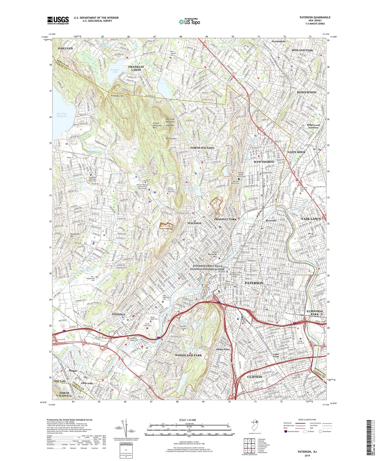
Paterson New Jersey US Topo Map
Couldn't load pickup availability
2019 topographic map quadrangle Paterson in the state of New Jersey. Scale: 1:24000. Based on the newly updated USGS 7.5' US Topo map series, this map is in the following counties: Passaic, Bergen, Essex. The map contains contour data, water features, and other items you are used to seeing on USGS maps, but also has updated roads and other features. This is the next generation of topographic maps. Printed on high-quality waterproof paper with UV fade-resistant inks.
Quads adjacent to this one:
West: Pompton Plains
Northwest: Wanaque
North: Ramsey
Northeast: Park Ridge
East: Hackensack
Southeast: Weehawken
South: Orange
Southwest: Caldwell
Contains the following named places: A M White Lodge Cemetery, Absalom Grundy School, Ahavath Joseph Jewish Cemetery, Albion Place, Alps Road Park, Barbour Mill Dam, Barbour Pond, Barbour Pond Park, Barbour's Park, Barnert Hospital, Benedictine Academy, Berdam Shopping Center, Beverly Way Park, Blessed Sacrament School, Boonstra Park, Borough of Haledon, Borough of Hawthorne, Borough of Midland Park, Borough of North Haledon, Borough of Prospect Park, Borough of Totowa, Borough of Woodland Park, Brandes Field Playground, Bridge Pond, Broadway Station, Butchers Pond, Caldwell Plaza, Calvary Baptist Community Health Center, Calvary Cemetery, Calvin Coolidge Elementary School, Camp Veritans, Cedar Lawn Cemetery, Central Elementary School, City of Paterson, Clifton Stadium, Columbia Terrace Park, Country Club Ponds, Deep Brook, Dey - Hogencamp Cemetery, Diamond Brook, Don Bosco Technical School, Dotterweich Field, Dundee Dam, Dundee Lake, East Side Park, Fair Lawn, Fair Lawn Memorial Cemetery, Fern River Park, Fornachon School, Frank D Zaccaria Memorial Park, Franklin Lake, Franklin School, Franklin Swamp, Garrett Mountain Reservation, Getty Avenue Lot Heliport, Glen Rock, Godwin School, Goffle Brook, Goffle Brook Park, Great Notch Reservoir, Great Notch Reservoir Dam, Grebe Pond, Haledon, Haledon Reservoir, Haledon Reservoir Dam, Hamlin School, Hawthorne, Hawthorne Memorial Pool, Hawthorne Station, High Mountain, High Mountain Golf Course, Highland Lake, Highland Lake Dam, Hinchcliffe Stadium, Hinchman Pond, Holy Sepulchre Cemetery, Island Park, Judith-Jerome Place Park, Kindred Hospital New Jersey at Wayne Hospital, Kossuth Street School, Lafayette Elementary School, Lake View, Lance Corporal Ralph Valt Memorial Park, Laurel Grove Cemetery, Lembo Heliport, Lincoln Elementary School, Lincoln School, Little Diamond Brook, Little Falls Census Designated Place, Little Falls Pump Station Passaic Valley Water Commission, Lotz Pond, Lower Blauvelt Lake, Lyncrest Elementary School, Lyncrest Park, Maple Lake, Maple Lake Dam, McDonald Drive Park, Memorial Park, Metropolitan Electric Heliport, Midland Park, Molly Ann Brook, Mount Cecchino, Mount Nebo Cemetery, Murchio Airport, Nash Park, New Bridge Landing Historic Park, New Street Reservoir, New Street Reservoir Dam, North Haledon, North Hawthorne Station, North Jersey Country Club, North Jersey Developmental Center, Number 1 Elementary School, Number 10 Elementary School, Number 11 Elementary School, Number 12 Elementary School, Number 13 Elementary School, Number 14 Elementary School, Number 15 Elementary School, Number 16 Elementary School, Number 17 Elementary School, Number 19 Elementary School, Number 20 Elementary School, Number 21 Elementary School, Number 24 Elementary School, Number 25 Elementary School, Number 26 Elementary School, Number 3 Elementary School, Number 4 Elementary School, Number 7 Elementary School, Number 9 Elementary School, Oak Lane Park, Oldham Pond, Osborne Park, Our Lady of Lourdes School, Overlook Park, Packanack Mountain, Passaic Falls, Passaic Valley Regional High School, Paterson, Paterson Dutch Cemetery, Paterson Great Falls National Historical Park, Paterson Station, Pearl Brook, Peckman River, Pennington Park, Point View Reservoir, Preakness, Preakness Brook, Preakness Census Designated Place, Preakness Healthcare Center, Preakness Hills Country Club, Preakness Mountain, Preakness Reformed Dutch Cemetery, Preakness School, Preakness Shopping Center, Preakness Valley, Preakness Valley Park, Prospect Park, Prospect Park Elementary School, Prospect Park Quarry, Public School 1, Public School 22, Public School 23, Ramapo Ridge Psychiatric Hospital, Rambaut Dam, Rambaut Lake, Randall Carter Elementary School, Reservoir Brook, Richard E Byrd Elementary School, Ridgewood Junction, Rigley's Park, River Station, Riverside, Riverside Terrace, Rumana Road Park, Saint Josephs Regional Medical Center, Saint Joseph's Wayne Hospital, Sandy Hill Park, Second Watchung Mountain, Shai Shacknai Memorial Park, Singac, Singac Census Designated Place, Slippery Rock Brook, South Paterson Station, Squaw Brook, Stanley M Levine Reservoir, Swins Ponds, T Bowl Shopping Center, Tintle Park, Totowa, Township of Little Falls, Township of Wayne, Township of Wyckoff, Troop B Heliport, Valley Ruse Shopping Center, Valley View Sanatorium, Van Houten Cemetery, Van Winkles Pond, Village Drive Park, Vreeland Avenue Station, Wabash Brook, Wanaque Aqueduct, Watchung Mountains, Wayne Census Designated Place, Wayne Hills Mall Shopping Center, Wayne Mall Shopping Center, Wayne McBride Executive Park, West Paterson Sewage Treatment Plant, West Side Park, Wightman Field, William Paterson University of New Jersey Census Designated Place, Woodland Park, Wortendyke, WRRH-FM (Franklin Lakes), Wyckoff Census Designated Place, Ziegler Pond, ZIP Codes: 07011, 07424, 07432, 07452, 07470, 07481, 07501, 07502, 07503, 07504, 07505, 07506, 07508, 07512, 07513, 07514, 07522, 07524