MyTopo
Clovis New Mexico US Topo Map
Couldn't load pickup availability
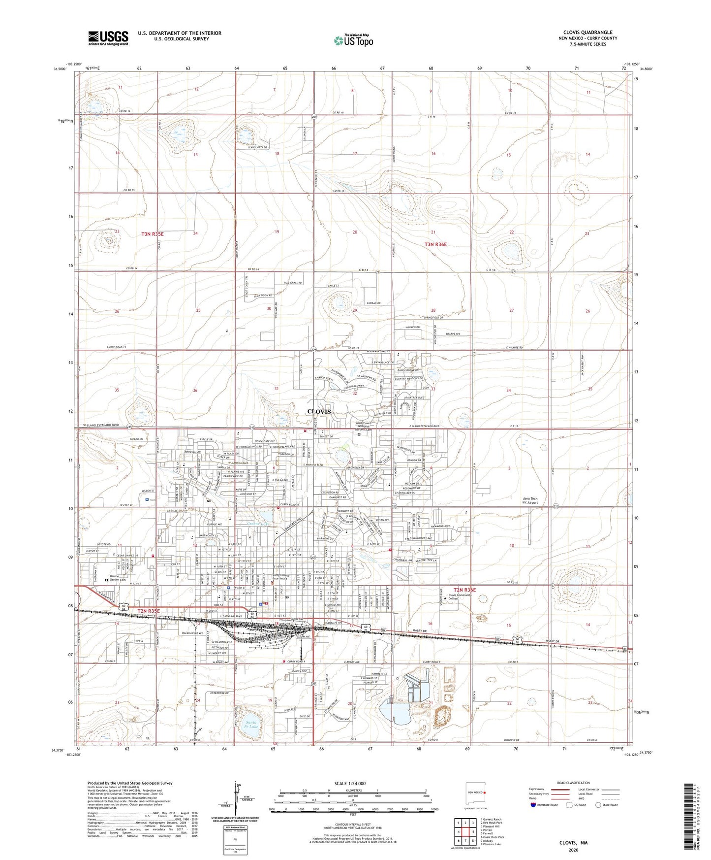
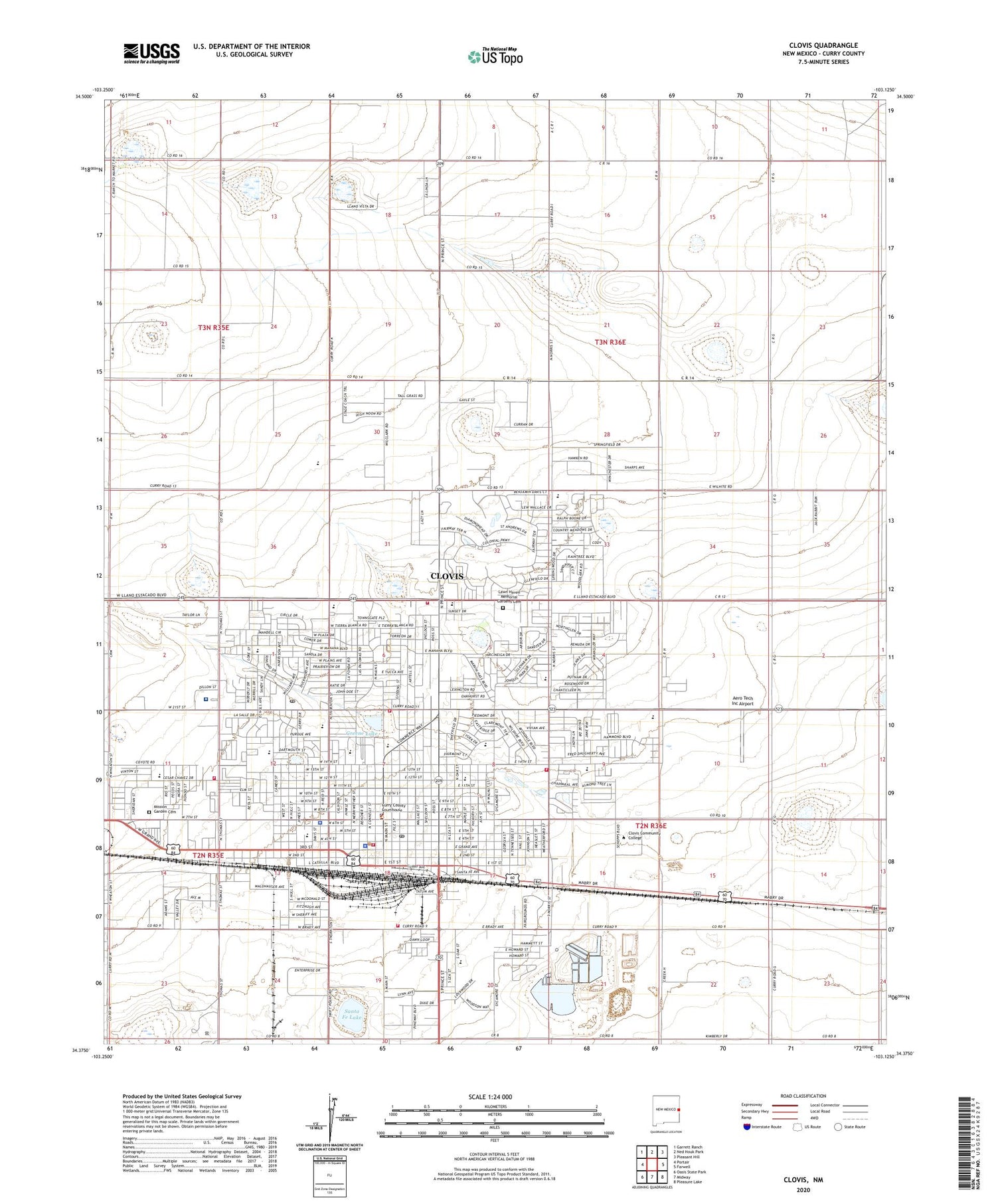
2020 topographic map quadrangle Clovis in the state of New Mexico. Scale: 1:24000. Based on the newly updated USGS 7.5' US Topo map series, this map is in the following counties: Curry. The map contains contour data, water features, and other items you are used to seeing on USGS maps, but also has updated roads and other features. This is the next generation of topographic maps. Printed on high-quality waterproof paper with UV fade-resistant inks.
Quads adjacent to this one:
West: Portair
Northwest: Garrett Ranch
North: Ned Houk Park
Northeast: Pleasant Hill
East: Farwell
Southeast: Pleasure Lake
South: Midway
Southwest: Oasis State Park
Contains the following named places: 10033 Water Well, 10034 Water Well, 10035 Water Well, 10036 Water Well, 10037 Water Well, 10038 Water Well, 10060 Water Well, 10061 Water Well, 10062 Water Well, 10063 Water Well, 10064 Water Well, 10065 Water Well, 10066 Water Well, 10067 Water Well, 10068 Water Well, 10069 Water Well, 10086 Water Well, 10088 Water Well, 10109 Water Well, 10154 Water Well, 10158 Water Well, 10165 Water Well, 10437 Water Well, 10442 Water Well, 10443 Water Well, 10444 Water Well, 10445 Water Well, 10447 Water Well, 10448 Water Well, 10561 Water Well, 10564 Water Well, 10748 Water Well, 10749 Water Well, 10772 Water Well, 10937 Water Well, 10938 Water Well, 10939 Water Well, 10940 Water Well, 11329 Water Well, Advent Christian, Aero Tech Inc Airport, Barry Elementary School, Bella Vista Elementary School, Bethal Assembly of God Church, Bible Missionary Church, Bickley School, Cameo Elementary School, Causey Baptist Church, CC-92 Water Well, Church of Christ, Church of God, Church of God Prophecy, City of Clovis, Clovis, Clovis Base Library, Clovis Community College, Clovis Community College Library, Clovis Evening School, Clovis Fire Department Station 1 Headquarters, Clovis Fire Department Station 2, Clovis Fire Department Station 3, Clovis Fire Department Station 4, Clovis Fire Department Station 5, Clovis High Plains Hospital Library, Clovis High School, Clovis Historical Marker, Clovis Police Department, Clovis Post Office, Clovis Post Office Northwest Station, Clovis Weather Station, Clovis-Carver Public Library, Curry County Sheriff's Office, Fairview Church, Fairview Church of the Nazarene, Faith Christian Fellowship Church, First Church of Christ Scientist, Forest Heights Church, Greene Lake, Highland Elementary School, Highland School, Hillcrest Park, Hotel Clovis Historic Site, James Bickley Elementary School, KCLV-AM (Clovis), KCLV-FM (Clovis), Kingdom Hall, La Casita Elementary School, Lawn Haven Memorial Gardens Cemetery, Lincoln Jackson Elementary School, Lockwood Elementary School, Marshall Junior High School, Mesa Elementary School, Mission Garden Cemetery, New Mexico State Police District 9 Clovis, North Plains Mall, Northside Church of Christ, Parkview Baptist Church, Parkview Elementary School, Place of Prayer, Plains Regional Medical Center, Potter Park, Railway Express Agency Building, Ranchvale Elementary School, Salvation Army, Sandia Baptist Church, Sandia Elementary School, Santa Fe Lake, Seventh Day Adventist Church, Templo Bautista, The Church of Jesus Christ of Latter Day Saints, United States Air Force Hospital Library, US Air Force Hospital Library, Victory Baptist Church, W D Gattis Junior High School, Westbrook Baptist Church, Westminster Presbyterian, Westside Church of Christ, Yucca Junior High School, Zia Elementary School