MyTopo
Holt Mountain New Mexico US Topo Map
Couldn't load pickup availability
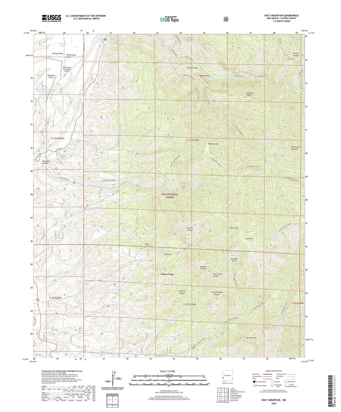
2020 topographic map quadrangle Holt Mountain in the state of New Mexico. Scale: 1:24000. Based on the newly updated USGS 7.5' US Topo map series, this map is in the following counties: Catron. The map contains contour data, water features, and other items you are used to seeing on USGS maps, but also has updated roads and other features. This is the next generation of topographic maps. Printed on high-quality waterproof paper with UV fade-resistant inks.
Quads adjacent to this one:
West: Glenwood
Northwest: Alma
North: Mogollon
Northeast: Bearwallow Mountain
East: Grouse Mountain
Southeast: Rice Ranch
South: Moon Ranch
Southwest: Wilson Mountain
Contains the following named places: Allotment Tank, Angels Roost, Black Tail Tank, Blue Jay Spring, Burns Spring, Cardinal Gap, Cave Spring, Cave Tank, CCC Tank, Chipmunk Spring, Clay Spring, Deer Park Canyon, Deer Park Canyon Prospects, Deer Park Spring, Deloche Trail, Dripping Gold Spring, East Fork Whitewater Creek, Fence Tank, Glenwood Airport, Glenwood Ranger District, Goat Corral Canyon Prospect, Goat Spring, Goat Water Tank, Goddard Canyon Prospects, Gold Hill, Goodard Tank, Hardscrabble Prospects, Holt Apache Trail, Holt Canyon Prospects, Holt Guard Station, Holt Mountain, Holt Mountain Trail, Holt Spring, Holt Tunnel, Huckleberry Spar Mine, Hunter Water Tank, Hunters Tank, Ida Bell and Bessie Number One Prospect, Independence Mine, Iron Bar Prospect, Iron Clad Claims, Iron Group Mine, Johnson Cabin, Kordic Claim, Lauderbaugh Prospect, Liberty Bell Number One Claim, Little Spar Prospects, Little Whitewater Creek, Little Whitewater Trail, Lone Pine Spring, Lone Star Group Mine, Lone Star Number Seven Prospect, Lower Seridan Spring, Lower Tank, Lucky Tank, M T Tank, Middle Tank, Midnight Spring, Moose Group Mine, Morning Star Prospects, Muddy Tank, Nabours Mountain, North Fork Dry Creek, North Fork Trail, Old Uncle John Mine, PDQ Tank, Pleasanton, Pleasanton Cemetery, Pleasanton Post Office, Red Colt Canyon Prospects, Red Colt Canyon Well, Red Shaft, Red Shaft Propsect, Red Tank, Schoolhouse Canyon Well, Sheldon Canon Windmill, Shelton Canyon Prospects, Sheridan Mountain, Sheridan Tank, Silted Up Tank, Skeleton Ridge, South Fork Trail, South Fork Whitewater Creek, Straight Up Trail, Sunshine Tank, Tennessee Meadow, The Catwalk Historical Marker, The Lime Kiln Mine, Thunderhead Workings, West Side Tank, White Water Mesa Tank, Whitetail Spring, Whitewater Campground, Whitewater Mesa, Whitewater Mesa Ranch Airport, Whitewater Trail, Wilcox Claims, Wilcox Peak, Wilcox Peak Prospects, Wilcox Prospects, York Tank, ZIP Code: 88039