
MyTopo
Mogollon New Mexico US Topo Map
Couldn't load pickup availability
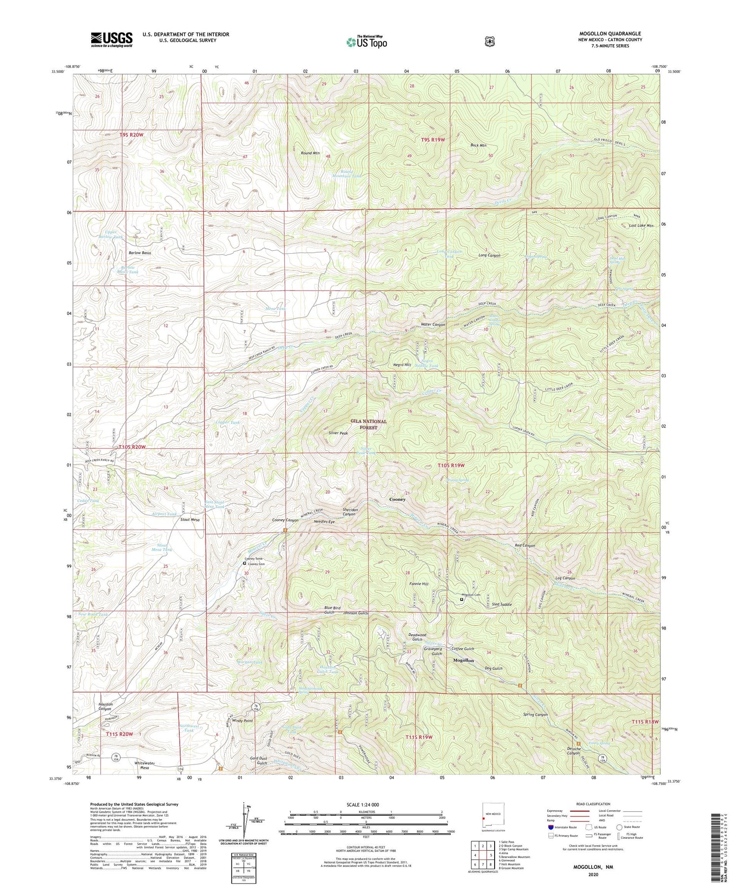
2020 topographic map quadrangle Mogollon in the state of New Mexico. Scale: 1:24000. Based on the newly updated USGS 7.5' US Topo map series, this map is in the following counties: Catron. The map contains contour data, water features, and other items you are used to seeing on USGS maps, but also has updated roads and other features. This is the next generation of topographic maps. Printed on high-quality waterproof paper with UV fade-resistant inks.
Quads adjacent to this one:
West: Alma
Northwest: Saliz Pass
North: O Block Canyon
Northeast: Sign Camp Mountain
East: Bearwallow Mountain
Southeast: Grouse Mountain
South: Holt Mountain
Southwest: Glenwood
Contains the following named places: Airport Tank, Alberta Group, Alberta Mine, Anna E. Group, Apache Group, Barlow Basin, Barlow Basin Tank, Bearup Mine, Bearup Spring, Bismark Lode, Black Steer Arroyo Well, Blackbird Lode, Blair Lode, Blue Bird Gulch, Blue Bird Lode, Braton Lode, Buck Mountain, Buffalo and Mountain View Prospect, Cedar Tank, Claremont, Clifton Prospect, Coffee Gulch, Comet Tunnel, Confidence Mine, Cooney, Cooney Canyon, Cooney Cemetery, Cooney Mine, Cooney Post Office, Cooney Tomb, Copper Creek, Copper Creek Well, Copper Tank, Cross Lode, Czar Mine, Dalton Lode, Dead Man Spring, Deadwood Gulch, Deadwood Mine, Deep Creek Ranch, Deep Down Mine, Deloche Canyon, Devils Creek Well, Dog Gulch, Duck 1-6, Dutch Boy Lode, East Stout Mesa Tank, Eberle Mine, Emperial Lode, Enterprise Mine, Eureka Mine, Fannie Hill, Fannie Mine, Fanny Spring, Floride Prospect, Free Milling Lode, Gold Dust Group, Gold Dust Gulch, Gold Dust Mine, Gold Dust Tank, Golden Bar Lode B, Golden Eagle Mine, Good Hope Lode, Graveyard Gulch, Graveyard Gulch Mine, Great Western Mine, Grove Ranch, Hogan Cabin, Hogan Cabin Trail, Hogan Spring, Horace Lode, Houston Canyon, Houston Gulch Tank, Humming Bird Lode, Hustler Group, Jackpot Lode, John Brothers Mine, Johnson Group, Johnson Gulch, Johnson Mine, Last Attemp Lode, Last Chance Mine, Leap Year Lode, Little Charlie Group, Little Charlie Mine, Little Deep Creek, Little Fannie Mine, Log Canyon, Log Canyon Trail, Lone Star Lode, Long Canyon Tank, Lost Lake Mountain, Lucky Cuss Deposit, Mascot Lode, Maud S Mine, Mesa Tank, Miner Well, Mineral Creek Well, Mogollon, Mogollon Cemetery, Mogollon Census Designated Place, Mogollon Historic District, Mogollon Historical Marker, Mogollon Post Office, Mogollon Theater Historic Site, Mogollon Volunteer Fire Department, Mogollon Weather Station, Morgan Tank, Morgan Well, Needles Eye, Negro Hill, Negro Saddle Tank, New Road Tank, North Alpine Lode, North Fork Devils Creek, Northwest Tank, Oaks Ranch, Oaks Tunnel, Old Strike Lode, Old Tom Lode, Pacific Mine, Phyllis, Pine Spring, Powerplant Road, Queen Mine, Red Bird Lode, Red Canyon, Red Canyon Trail, Round Mountain, Round Mountain Tank, Seminole Group, Sheridan Canyon, Silver Bar Lode Number 2 Group, Silver Creek, Silver Fountain Lode, Silver Peak, Silver Peak Tank, Slaughterhouse Spring, Slayback Deposit, Sled Saddle, Socorro Group, South Alpine Mine, South Fork Silver Creek, Spring Canyon, Stout Mesa, Stout Mesa Tank, The Catwalk National Recreation Trail, The Kay L-1, Thurman Lode, Tip Top Lode, Top Lode, Trilby Mine, Upper Barlow Tank, Valentine Lode, Virginina Lode, Waldorf Lode, Water Canyon, Water Canyon Spring, Whitewater Campground Area Prospect, Whitney Lode, Windy Point


