MyTopo
Silver City New Mexico US Topo Map
Couldn't load pickup availability
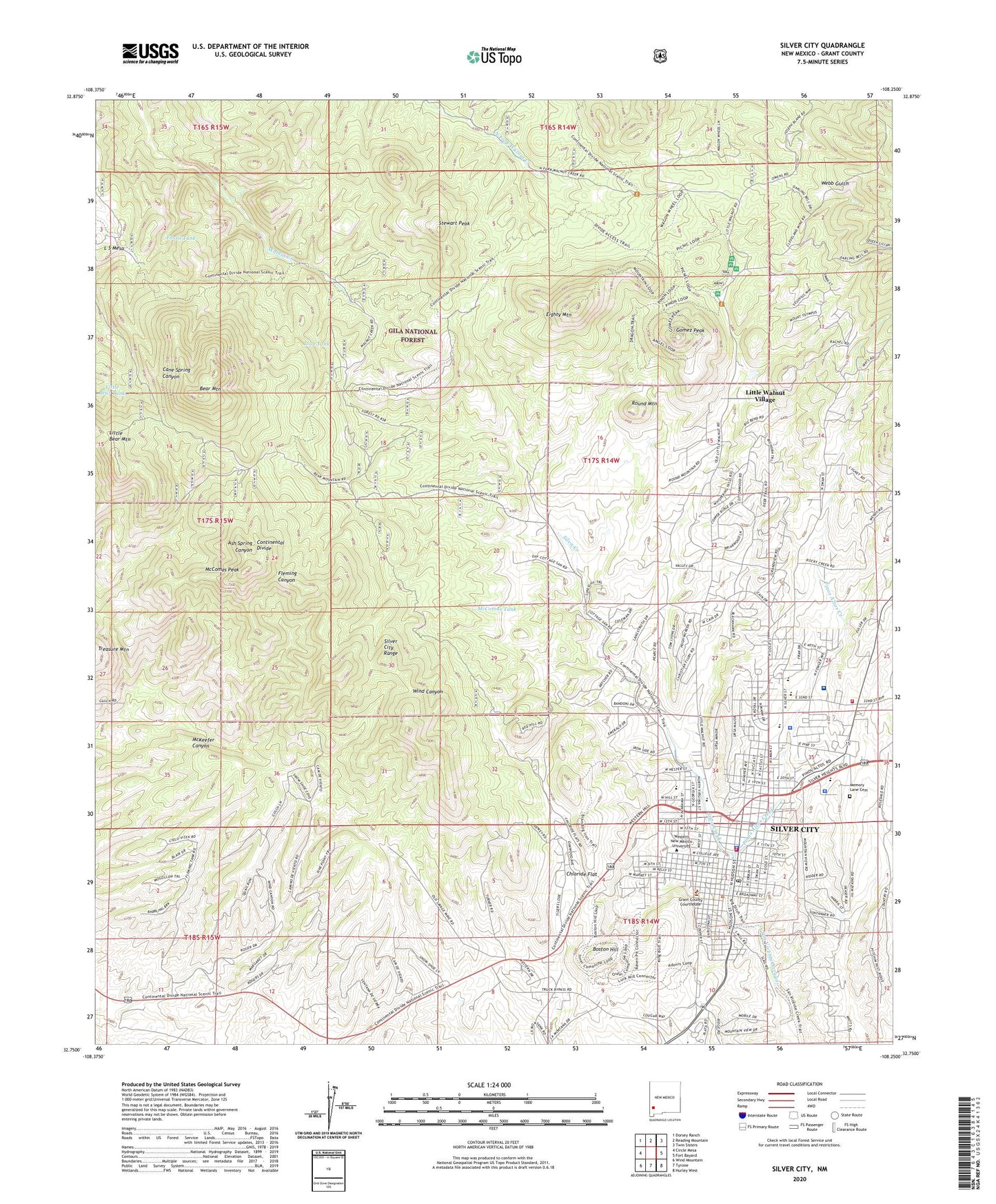
2020 topographic map quadrangle Silver City in the state of New Mexico. Scale: 1:24000. Based on the newly updated USGS 7.5' US Topo map series, this map is in the following counties: Grant. The map contains contour data, water features, and other items you are used to seeing on USGS maps, but also has updated roads and other features. This is the next generation of topographic maps. Printed on high-quality waterproof paper with UV fade-resistant inks.
Quads adjacent to this one:
West: Circle Mesa
Northwest: Dorsey Ranch
North: Reading Mountain
Northeast: Twin Sisters
East: Fort Bayard
Southeast: Hurley West
South: Tyrone
Southwest: Wind Mountain
Contains the following named places: 00217 Water Well, 00222 Water Well, 00224 Water Well, 00226 Water Well, 00231 Water Well, 00236 Water Well, 00240 Water Well, 00244 Water Well, 00246 Water Well, 00249 Water Well, 00250 Water Well, 00254 Water Well, 00260 Water Well, 00421 Water Well, 00424 Water Well, 00427 Water Well, 00428 Water Well, 00432 Water Well, 00434 Water Well, 00441 Water Well, 00442 Water Well, 10034 Water Well, Apostolic Assembly of the Faith in Jesus Christ, Arise and Shine School, Ash Spring Canyon Prospect, Atlantic, Atlas Number 2, Baptist Student Center, Bear Mountain, Bear Mountain Group, Blacks Addition Historic District Historic Site, Boston Hill, Bowden Hall Historic Site, Breman, Bullard Hotel Historic Site, C W Marriott House, Calvary Baptist Church, Chewawa Mine, Chihuahua Hill Historic District, Chloride Flat, Christian Science Society Church, Church of Christ, Church of God, Church of the Nazarene, Cleveland Mine, College Street School, Connecticut Mine, Cottage Sanatorium, David Abraham House Historic Site, Divide Prospect, Down to Earth School, Eighty Mountain, Emma, First Assembly of God Church, First Baptist Church, First Church of the Nazarene, Fleming Canyon Tank, Fleming Hall, Fossil Tank, Franchise Group Mine, Francis McGray Gallery, Franks, Franks RNC Water Well, G 218 Water Well, G 220 Water Well, G 239 Water Well, Gila Regional Medical Center, Gila School, Gomez Peak, Graham Gymnasium Historic Site, Grant County Courthouse, Grant County Sheriff's Office, Great American, Guadalupe Montessori School, H B Ailman House Historic Site, Harrison H Schmidt Elementary School, Hidden Treasure, Hilltop Group Mine, Houston-Thomas Mine, Indian Hills Baptist Church, Inevitable Mine, Isaac N Cohen House, Jose Barrios Elementary School, Kingdom Hall, KSIL-AM (Silver City), L S Mesa, La Plata Middle School, Light Hall Historic Site, Lion Tank, Little Bear Mountain, Little Bear Tank, Little Walnut Picnic Area, Little Walnut Village, Little Walnut Village Census Designated Place, Luck Manganese Mine, Martin Maher House Historic Site, McComas Peak, McComas Tank, Memory Lane Cemetery, Meredith and Allman Bank Block Historic Site, Messiah Lutheran Church, Milton Group, Minnie L Brumback House Historic Site, Mollie Gibson Group Mine, New Mexico State Police District 12 Silver City, O S Warren House Historic Site, Pinos Altos Creek, Potters House Christian Church, Prima Iglesia Buatista, Providencia, Prussia Mine, Rescue, Ritch Hall Historic Site, Round Mountain, Saint Francis Newman Center, Saint Marys Academy, Saint Marys Academy Historic District, San Vicente Arroyo, Savage Prospect, Seventy-Six, Silva Creek, Silver City, Silver City Christian Academy, Silver City Division, Silver City Fire Department Station 1, Silver City Fire Department Station 2, Silver City Historic District, Silver City Historical Marker, Silver City Museum, Silver City North Addition Historic District, Silver City Police Department, Silver City Post Office, Silver City Public Library, Silver City Range, Silver City Water Wells, Silver City Water Works Building Historic Site, Silver City Weather Station, Silver High School, Silver Ribbon Mine, Silver Wedge, Stewart Peak, Stine-Fleming House Historic Site, Stout Intermediate School, The Church of Latter Day Saints, The Episcopal Church of the Good Shepard, Thomas Conway House Historic Site, Town of Silver City, Treasure Hill Historic Site, Treasure Mountain Shaft, Virgin Group Mine, Volcano Group, Walnut Creek Corral and Well, Western New Mexico University, Western New Mexico University Historic District, Western New Mexico University Museum, YCC Trick Tank