MyTopo
Canajoharie New York US Topo Map
Couldn't load pickup availability
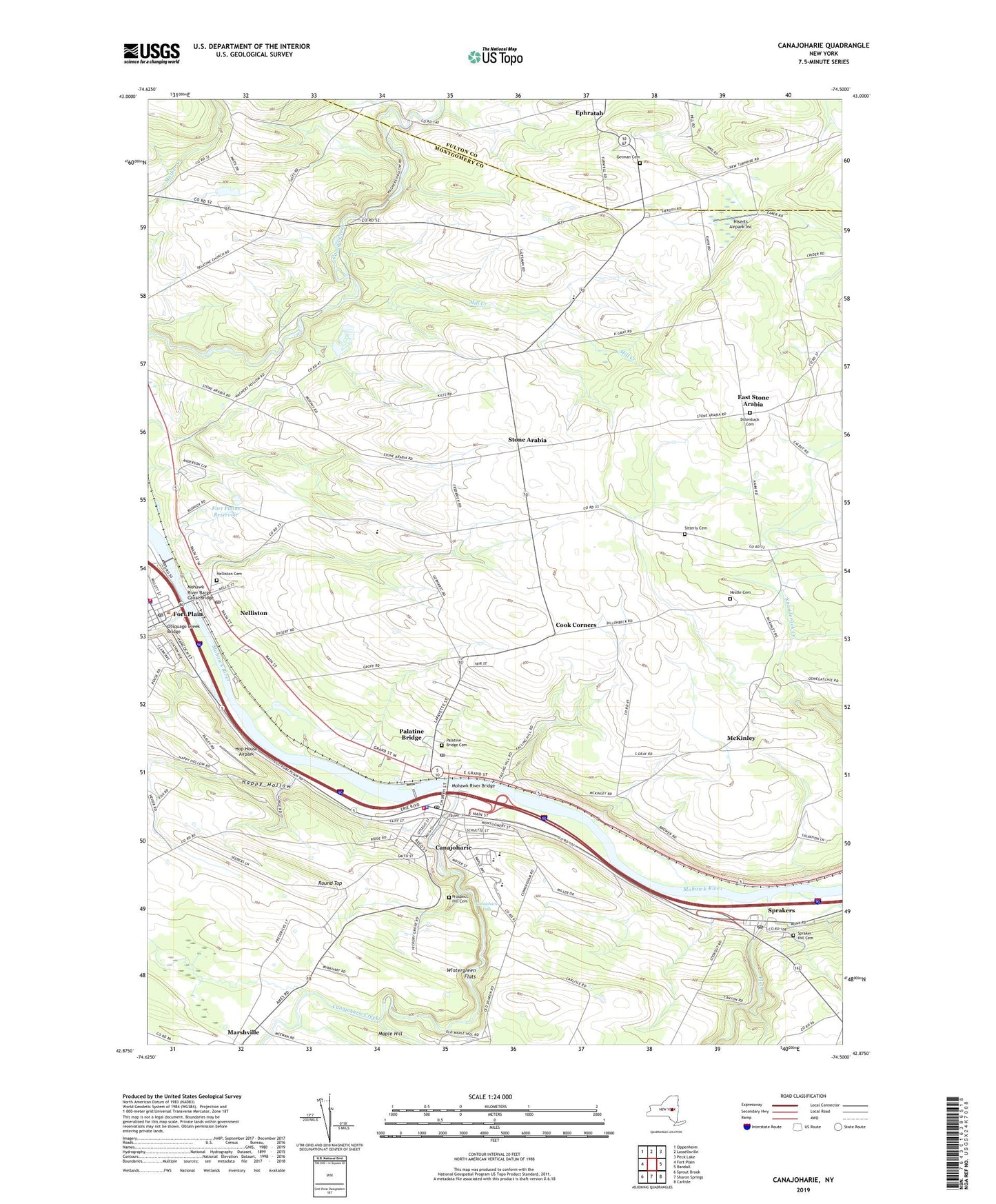
2019 topographic map quadrangle Canajoharie in the state of New York. Scale: 1:24000. Based on the newly updated USGS 7.5' US Topo map series, this map is in the following counties: Montgomery, Fulton. The map contains contour data, water features, and other items you are used to seeing on USGS maps, but also has updated roads and other features. This is the next generation of topographic maps. Printed on high-quality waterproof paper with UV fade-resistant inks.
Quads adjacent to this one:
West: Fort Plain
Northwest: Oppenheim
North: Lassellsville
Northeast: Peck Lake
East: Randall
Southeast: Carlisle
South: Sharon Springs
Southwest: Sprout Brook
Contains the following named places: Arkell Museum, Canajoharie, Canajoharie Creek, Canajoharie Falls, Canajoharie Library, Canajoharie Middle School, Canajoharie Post Office, Canajoharie Reservoir, Canajoharie Senior High School, Canajoharie Village Wastewater Treatment Plant, Canajoharie Village Water Filtration Plant, Canajoharie Volunteer Fire Department, Canary Dairy, Canjoharie Toll Plaza, Christmans Corners, Cook Corners, Dillenback Cemetery, East Hill School, East Stone Arabia, Episcopal Church of the Good Shepherd, First Reformed Church, Flat Creek, Fort Plain, Fort Plain Fire Department, Fort Plain Free Library, Fort Plain Post Office, Fort Plains Reservoir, Getman Cemetery, Happy Hollow, Hiserts Airpark Inc, Hop House Airpark, Kingdom Hall of Jehovahs Witnesses, Marshville, McKinley, Meadow Brook School, Mid County Volunteer Ambulance Service, Mill Creek, Mohawk River Barge Canal Bridge, Mohawk River Bridge, Montgomery County Sewer District 1 Sewage Treatment Plant, Nelliston, Nelliston Cemetery, Nelliston Historic District, Nelliston Post Office, Nelliston Public School, Nestle Cemetery, Otsquago Creek, Otsquago Creek Bridge, Palatine Bridge, Palatine Bridge Cemetery, Palatine Bridge Post Office, Palatine Bridge Underground Reservoir, Palatine Nursing Home, Pavlus Orchard, Prospect Hill Cemetery, Round Top, School Number 10, School Number 13, School Number 4, School Number 6, School Number 8, Sitterly Cemetery, Spraker Hill Cemetery, Sprakers, Sprakers Post Office, Starlight Acres, Stone Arabia, Town of Palatine, Trinity Lutheran Church, Valley Alliance Church, Village of Canajoharie, Village of Nelliston, Village of Palatine Bridge, Wagner Hollow, WCAN-FM (Canajoharie), West Hill School, Wintergreen Flats, ZIP Codes: 13410, 13428