MyTopo
Thiells New York US Topo Map
Couldn't load pickup availability
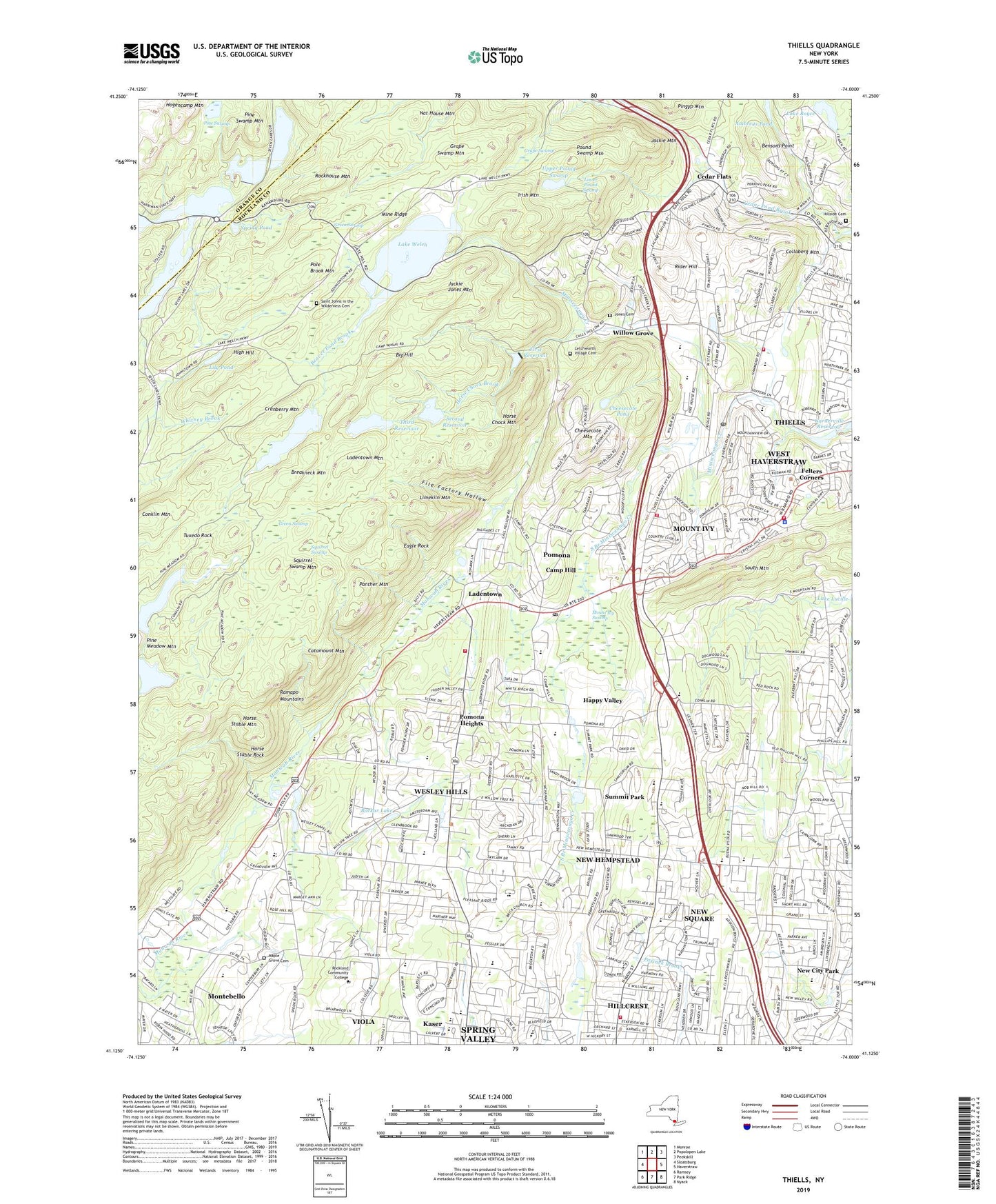
2019 topographic map quadrangle Thiells in the state of New York. Scale: 1:24000. Based on the newly updated USGS 7.5' US Topo map series, this map is in the following counties: Rockland, Orange. The map contains contour data, water features, and other items you are used to seeing on USGS maps, but also has updated roads and other features. This is the next generation of topographic maps. Printed on high-quality waterproof paper with UV fade-resistant inks.
Quads adjacent to this one:
West: Sloatsburg
Northwest: Monroe
North: Popolopen Lake
Northeast: Peekskill
East: Haverstraw
Southeast: Nyack
South: Park Ridge
Southwest: Ramsey
Contains the following named places: Ambreys Pond, Antrim Playhouse, Bais Yaakov High School of Spring Valley, BAIS Yakov of Ramapo, Beaver Pond Brook, Bensons Point, Big Hill, Bnos Israel Girls High School, Bockar Lake, Breakneck Mountain, Breakneck Pond, Breakneck Ridge Trail, Brick Church School, Brucker Hall, Camp Bullowa, Camp Hill, Camp Hill School, Camp Jawonio, Camp Wakonda, Catamount Mountain, Cedar Flats, Cheesecote Mountain, Cheesecote Mountain Town Park, Cheesecote Pond, Chestnut Grove School, Collaberg Mountain, Congregation BAIS Malka, Congregation Bais Yehudah, Conklin Mountain, Conklins Crossing, Cranberry Mountain, Darbe Mehr Zoroastrian Temple, David B Roche Volunteer Fire Company Arthur D Dresdner Substation, Doctor Robert L Yeager Center, Don Bosco Juniorate, Eagle Rock, English Church School, Fairway Park, Felters Corners, File Factory Hollow, First Reservoir, First United Methodist Church, Fountain Head Mobile Home Park, Friedwald Center for Rehabilitation and Nursing, Garnerville Reservoir, Grace Church of Suffern, Grandview Elementary School, Grape Swamp, Grape Swamp Mountain, Green Swamp, Gurnee Lake, Happy Valley, Haverstraw Town Hall, Hempstead Elementary School, Herriman Farm School, High Hill, Hillcrest, Hillcrest Census Designated Place, Hillcrest Elementary School, Hillcrest Fire Company 1, Hillcrest Fire Company 1 Greg Sikorsky Station, Hillside Cemetery, Hogen Camp Mine, Hogencamp Mountain, Horse Chock Brook, Horse Chock Mountain, Horse Stable Mountain, Horse Stable Rock, Iglesia Alianza Biblica Cristiana, Irish Mountain, Jackie Jones Mountain, Jackie Mountain, Jones Cemetery, Kanawauke Circle, Kanes Open Camp, Kingdom Hall of Jehovah's Witnesses, Kings Gate Park, Ladentown, Ladentown Mountain, Lake Askoti, Lake Boyce, Lake Kanawauke, Lake Skannatati, Lake Tiorati Brook, Lake Wanoksink, Lake Welch, L'Dor Assisted Living Center, Letchworth Village Cemetery, Letchworth Village Developmental Center, Lily Pond, Lime Kiln Elementary School, Limekiln Mountain, Link Elementary School, Lower Pound Swamp, Lubavitch Chabad of Monsey, Maple Grove Cemetery, Matterhorn Nursery, Mazzaleone Park, Merrill L Colton School, Mikvah of Rockland County, Mine Ridge, Minisceogo Golf Course, Monsey Jewish Center, Montebello, Mount Ivy, Mount Ivy Census Designated Place, Mount Ivy County Park, Mount Ivy Swamp, Nat House Mountain, New City Gospel Fellowship Church, New City Park, New Hempstead, New Hempstead Presbyterian Church, New Hempstead School, New Square, New York Country Club, Nike Site NY-99C, Nike Site NY-99L, North Rockland High School, Orchards of Concklin, Panther Mountain, Park Evangelical Free Church, Parkway Mobile Home Park, Patriot Hills Golf Club, Philip J Rotella Golf Course, Pine Swamp, Pine Swamp Mountain, Pole Brook Mountain, Pomona, Pomona Heights, Pomona Middle School, Pomona Post Office, Pound Swamp Mountain, Quaker Park, Ramapo High School, Ramapo Mountains, Reformed Church of West New Hempstead, Reuben Gittelman Hebrew Day School, Rider Hill, Risen King Alliance Church, Rockhouse Mountain, Rockland Baptist Church, Rockland Christian School, Rockland Community College, Rockland County, Rockland County Health and Social Services Complex, Saint Boniface Roman Catholic Church, Saint Johns Church, Saint Johns in the Wilderness Cemetery, Saint Olav Chapel, Saint Pakhomious Coptic Church, Second Reservoir, Sherwood Path, South Branch Minisceongo Creek, South Mountain County Park, Spook Rock Golf Course, Spring Hill Community Ambulance Corps, Spring Pond, Squirrel Swamp, Squirrel Swamp Mountain, Sri Ranganatha Temple, Suffern-Bear Mountain Trail, Suffren Senior High School, Summit Park, Summit Park Elementary School, Temple Beth Sholom, The Brick Church, The Church of Jesus Christ of Latter Day Saints, Thiells, Thiells Census Designated Place, Thiells Elementary School, Thiells Methodist Church, Thiells Post Office, Thiells Volunteer Fire Department, Third Reservoir, Torne Mount Ivy Trail, Town of Haverstraw, Town of Ramapo, Tuxedo Rock, Unitarian Universalist Congregation of Rockland, Upper Pound Swamp, Vacation Camp for the Blind, Village of Montebello, Village of New Hempstead, Village of New Square, Village of Pomona, Village of Wesley Hills, Viola, Viola Census Designated Place, Viola Elementary School, Welch Camp, Wesley Chapel, Wesley Hills, Wesley Hills Synagogue, Wesley Hills Village Hall, West Clarkstown Jewish Center, Willow Grove, Willow Grove Middle School, Woodglen Elementary School, Woodtown Trail, WRKL-AM (New City), Yeshiva Bath Mikroh, Yeshiva Ohr Reuven, ZIP Codes: 10901, 10923, 10970, 10980, 10984