MyTopo
Santeetlah Creek North Carolina US Topo Map
Couldn't load pickup availability
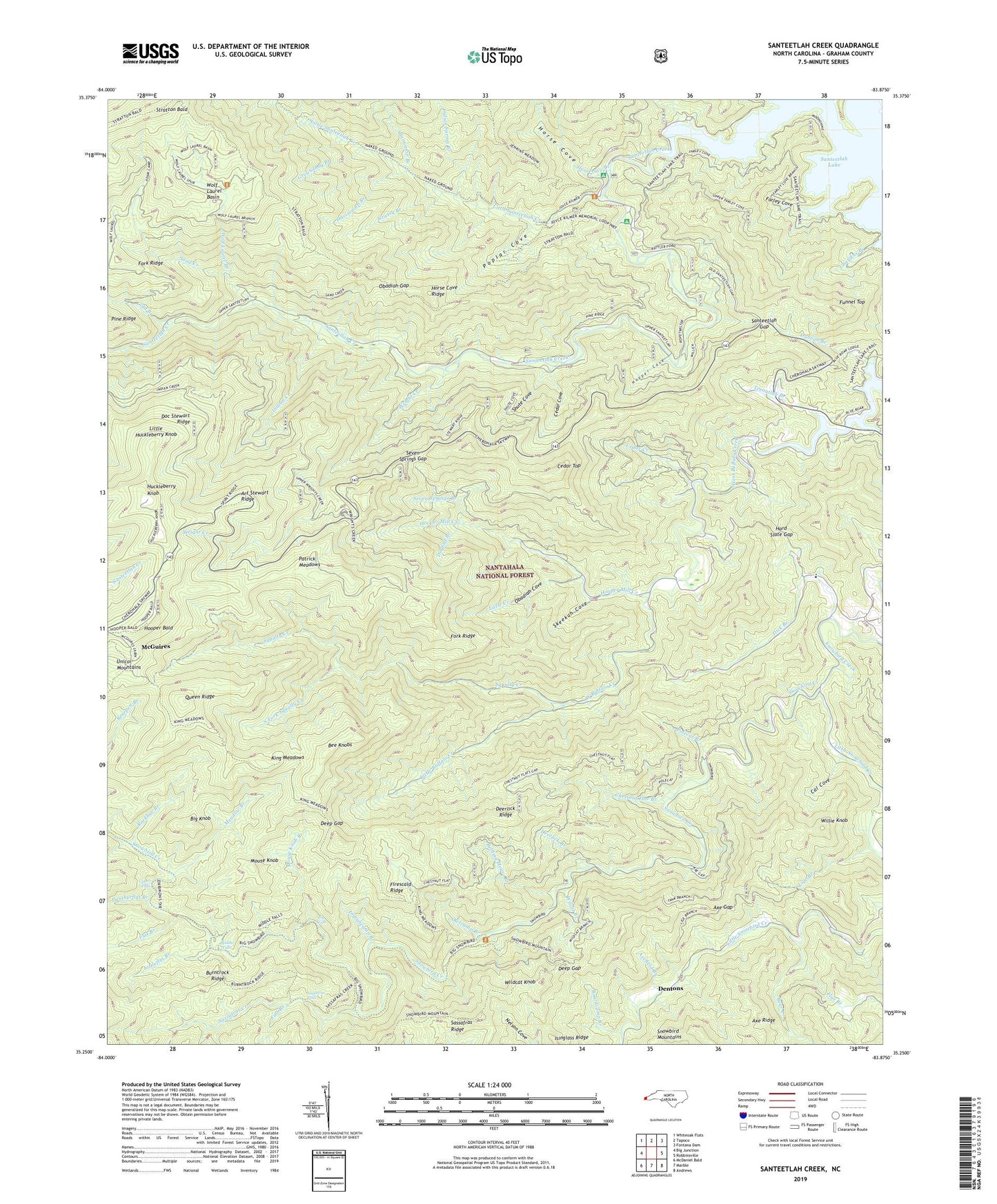
2019 topographic map quadrangle Santeetlah Creek in the state of North Carolina. Scale: 1:24000. Based on the newly updated USGS 7.5' US Topo map series, this map is in the following counties: Graham. The map contains contour data, water features, and other items you are used to seeing on USGS maps, but also has updated roads and other features. This is the next generation of topographic maps. Printed on high-quality waterproof paper with UV fade-resistant inks.
Quads adjacent to this one:
West: Big Junction
Northwest: Whiteoak Flats
North: Tapoco
Northeast: Fontana Dam
East: Robbinsville
Southeast: Andrews
South: Marble
Southwest: McDaniel Bald
Contains the following named places: Adamcamp Branch, Ammons Cove, Art Stewart Ridge, Avey Creek, Axe Gap, Axefield Branch, Bear Creek, Bearden Branch, Bee Knobs, Belding House Branch, Big Falls, Big Knob, Boardcamp Branch, Burntrock Ridge, Cal Cove, Cedar Cliff Church, Cedar Cove, Cedar Creek, Cedar Top, Charikus Branch, Chestnut Flat Branch, Cold Branch, Daviscamp Branch, Deep Gap, Deerlick Branch, Deerlick Ridge, Dentons, Dick Branch, Doc Stewart Ridge, Dogfall Branch, Duncan Branch, Fall Branch, Farley Cove, Firescald Ridge, Flat Branch, Fork Ridge, Funnel Top, Goldie Deaden, Grassy Branch, Groundhog Branch, Hard Slate Gap, Hooper Bald, Hooper Cove, Hooper Mill Creek, Horse Cove, Horse Cove Campground, Horse Cove Ridge, Horsecove Branch, Huckleberry Knob, Indian Creek, Indian Spring Branch, Indiancamp Branch, Isinglass Ridge, Jess Teeseteska Land Tract, Joyce Kilmer Memorial, Joyce Kilmer Picnic Area, Junction, King Meadows, Lige Branch, Little Buffalo Creek, Little Creek, Little Huckleberry Knob, Little Santeetlah Creek, Little Snowbird Creek, Littleflat Branch, Lovin Branch, McGuires, Meadow Branch, Middle Falls, Mount Nebo Church, Mouse Knob, Mouse Knob Branch, Obadiah Cove, Obadiah Gap, Owlcamp Branch, Pantherflat Branch, Patrick Meadows, Polecat Branch, Poplar Cove, Queen Ridge, Rattler Ford, Rattler Ford Campground, Rockbar Branch, Sand Creek, Santeetlah Creek, Santeetlah Gap, Santeetlah Hunt Shelter Camp, Sassafras Creek, Sassafras Falls, Seven Springs Branch, Seven Springs Gap, Shute Cove, Skeekah Cove, Snowbird School, South Fork Squally Creek, Squally Creek, Stewart Cabin, Stratton Bald, Tecoatlah 364 482 Land Tract, Teeoatlah Branch, Tom Kalonuheska Land Tract, Upper Falls, Wilcat Branch, Wildcat Knob, Willie Knob, Wilson Cabin, Wolf Laurel Basin, Wolf Laurel Branch, Wright Creek