MyTopo
Bryan Ohio US Topo Map
Couldn't load pickup availability
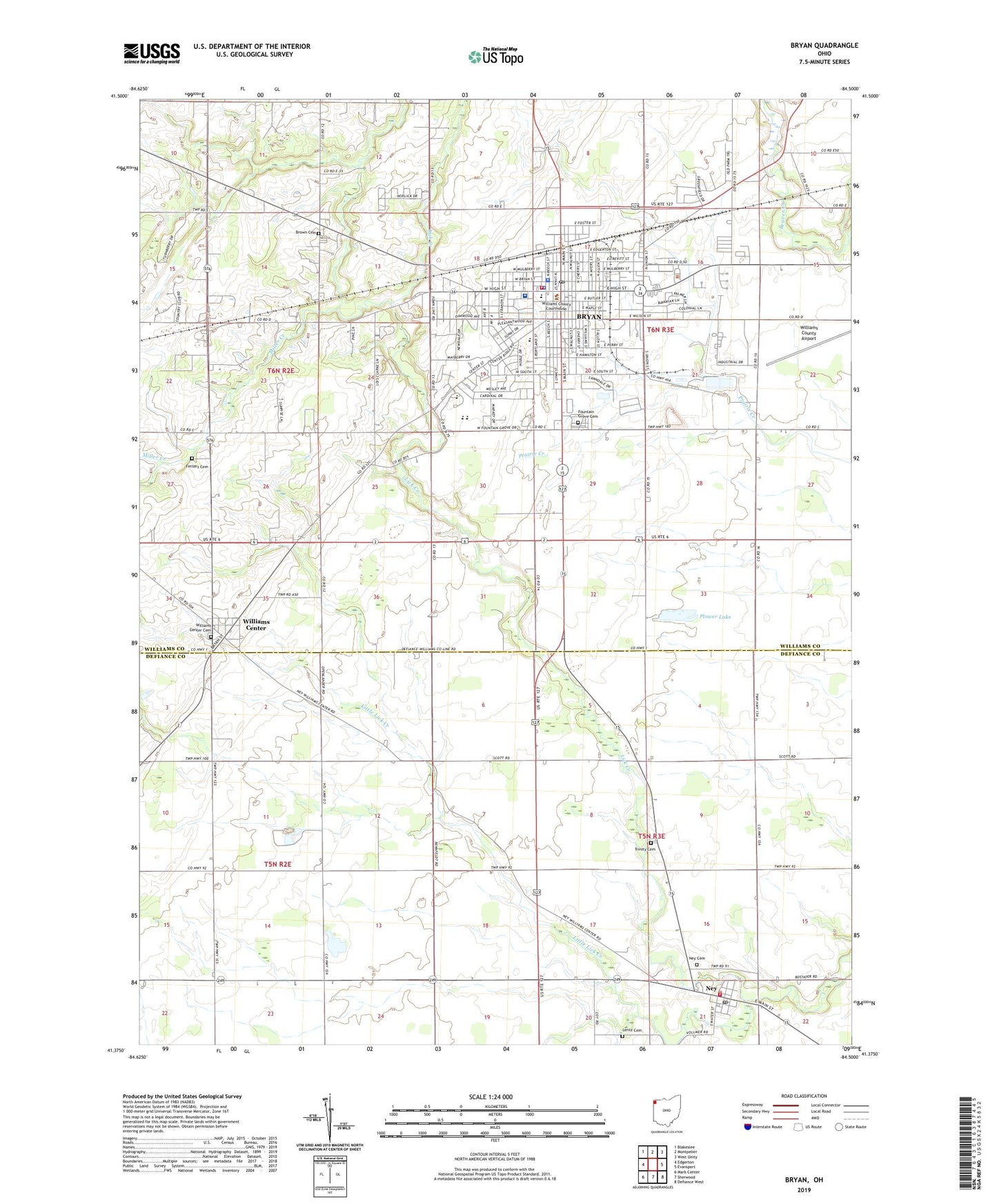
2019 topographic map quadrangle Bryan in the state of Ohio. Scale: 1:24000. Based on the newly updated USGS 7.5' US Topo map series, this map is in the following counties: Williams, Defiance. The map contains contour data, water features, and other items you are used to seeing on USGS maps, but also has updated roads and other features. This is the next generation of topographic maps. Printed on high-quality waterproof paper with UV fade-resistant inks.
Quads adjacent to this one:
West: Edgerton
Northwest: Blakeslee
North: Montpelier
Northeast: West Unity
East: Evansport
Southeast: Defiance West
South: Sherwood
Southwest: Mark Center
Contains the following named places: Apostolic Gospel Church, Bona Vesta, Bona Vesta United Brethren Church, Bona Vista, Brown Cemetery, Bryan, Bryan Christian and Missionary Alliance Church, Bryan Church of the Nazarene, Bryan Downtown Historic District, Bryan Fire Department, Bryan High School, Bryan Junior High School, Bryan Middle School, Bryan Mobile Home Park, Bryan Municipal Building, Bryan Police Department, Bryan Post Office, Bryan Seventh Day Adventist Church, Bryan Sewage Treatment Plant, Bryan Theatre, Bryan Worship Center, Buckeye Golf Course, City of Bryan, Community Hospitals and Wellness Centers, De Iglesia Cristianos, Durham Estates, Eastland Baptist Church, Faith United Methodist Church, Fetters Cemetery, First Assembly of God Church, First Baptist Church, First Brethren Church, First Church of Christ, First Lutheran Church, First Methodist Episcopal Church, First Presbyterian Church, Fountain City Historic District, Fountain Grove Cemetery, Freedom, Garver Park, Holly Addition, Hub Drive-In, Immaculate Conception Catholic Church, Jerrys First Addition, Krohns Acres, Lentz Cemetery, Lick Creek Church of the Brethren, Lincoln Elementary School, Little Lick Creek, Memorial United Brethren Church, Miller Creek, Miracle Revival Center, Moore Park, N and L Farms, New Life Temple, Ney, Ney Cemetery, Ney Church of God, Ney Junior High School, Ney Post Office, Ney United Methodist Church, Norlick Place, Oak Meadows, Pleasant Meadows, Plover Lake Addition, Plower Lake, Rachel Heights, Saint Patrick Roman Catholic Church, School Number 1, School Number 2, School Number 3, School Number 4, School Number 5, School Number 6, School Number 7, School Number 8, School Number 9, The Church of Jesus Christ of Latter Day Saints, Township of Pulaski, Township of Washington, Tree Meadows Mobile Home Park, Trinity Cemetery, Trinity Episcopal Church, Trinity Lutheran Church, Village of Ney, Washington Elementary School, Washington Township Fire Department, WBNO-FM (Bryan), Wesley United Methodist Church, Williams Center, Williams Center Cemetery, Williams County Airport, Williams County Courthouse, Williams County Emergency Medical Services, Williams County Emergency Medical Services Medic 2, Williams County Jail, Williams County Sheriff's Office, Willow Glenn, WQCT-AM (Bryan), ZIP Code: 43506