MyTopo
Cambridge Ohio US Topo Map
Couldn't load pickup availability
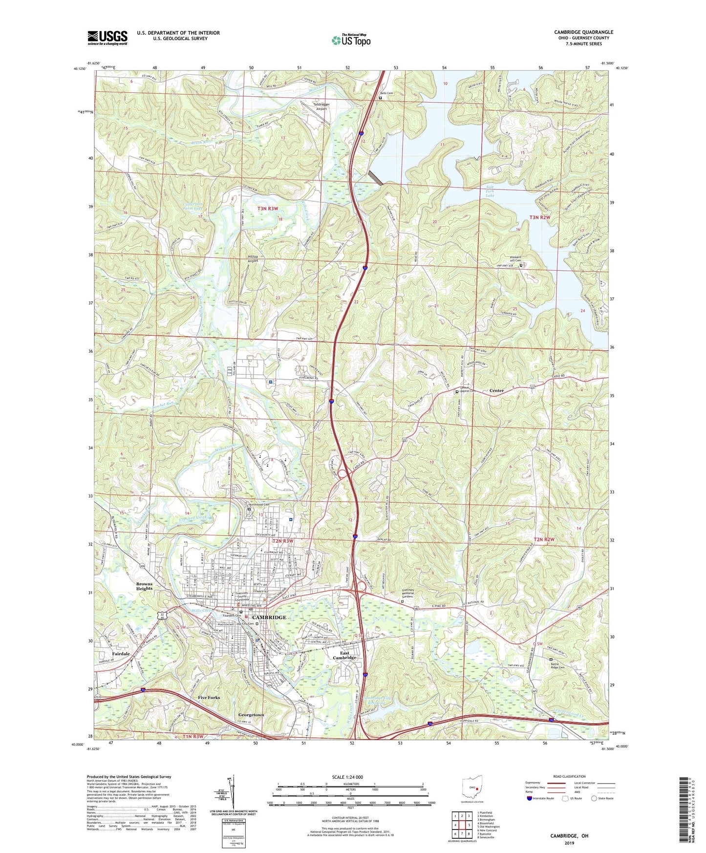
2019 topographic map quadrangle Cambridge in the state of Ohio. Scale: 1:24000. Based on the newly updated USGS 7.5' US Topo map series, this map is in the following counties: Guernsey. The map contains contour data, water features, and other items you are used to seeing on USGS maps, but also has updated roads and other features. This is the next generation of topographic maps. Printed on high-quality waterproof paper with UV fade-resistant inks.
Quads adjacent to this one:
West: Bloomfield
Northwest: Plainfield
North: Kimbolton
Northeast: Birmingham
East: Old Washington
Southeast: Senecaville
South: Byesville
Southwest: New Concord
Contains the following named places: Abledell, Adair's Trailer Park, Armstrong School, Barnes Mill, Barr School, Barton Manor, Battle Ridge Cemetery, Beckett United Methodist Church, Bells Cemetery, Bethel Apostolic Church, Black, Browns Heights, Brush Run, Calvary Church, Cambridge, Cambridge Alliance Church, Cambridge Behavioral Hospital, Cambridge Bible Church, Cambridge City Administration Building, Cambridge City Reservoir, Cambridge City Reservoir Dam, Cambridge Fire Department, Cambridge Glass Museum, Cambridge High School, Cambridge Junior High School, Cambridge Municipal Court, Cambridge Police Department, Cambridge Post Office, Cambridge Square Plaza Shopping Center, Cambridge State Mental Health and Developmental Center, Cambridge Waterworks, Cedar Hills, Center, Center Baptist Cemetery, Chalfant Chapel, Chestnut Ridge School, Christ Lutheran Church, Christ United Methodist Church, Church of Christ, Church of God of Prophecy, Church of the Good Shepherd, City of Cambridge, City of Cambridge Sewage Treatment Plant, Clio, Clio Post Office, Coventry Estates, Craig, Craig Post Office, Crooked Creek, Culbertson Farm Lake, Culbertson Farm Lake Dam, Degenhart Museum, East Cambridge, East Cambridge Methodist Church, Eastmoor, Fairdale, Fairmont, Faith United Methodist Church, First Baptist Church, First Christian Church, First Church of God, First Nazarene Church, First Presbyterian Church, First United Methodist Church, Five Forks, Founders Cemetery, Fourmile Hill Church, Foursquare Gospel Church, Free Methodist Church, Garfield Elementary School, Georgetown, Glass Plant Public School, Greenwood Trailer Park, Guernsey County Childrens Home, Guernsey County Courthouse, Guernsey County Historical Museum, Guernsey County Law Library, Guernsey County Memory Gardens, Guernsey County Public Library, Henderson Heights, Hilltop Airport, Independence School, Jack D Hendricks Memorial Park, Kingdom Hall of Jehovahs Witnesses, Leatherwood Creek, Lincoln Elementary School, Macedonia Baptist Church, Meadow Village, Mineral Point School, Mineral Siding, Mud Run, Ninth Street United Methodist Church, Northgate, Northside Park, Northwood Cemetery, Oakland Elementary School, Ohio State Highway Patrol - Cambridge Patrol Post, Old City Cemetery, Oldham, Oldham Post Office, Park School, Pilgrim Holiness Church, Pleasant Hill Cemetery, Pleasant Hill Church, Pleasant Valley School, Saint Benedict Catholic Church, Saint Benedicts High School, Saint Johns Episcopal Church, Salt Fork, Salt Fork Lake, Salt Fork Lodge Heliport, Salt Fork Reservoir Dam, Salt Fork School, Salt Fort Dam, Sarchet Run, Second Baptist Church, Second Evangelical United Brethren Church, Second United Presbyterian Church, Sherrard School, Slaughter Hill School, Southeastern Ohio Regional Medical Center, Stewart Memorial United Brethren in Christ Church, Sugartree Fork, Sunnymeade, Sycamore Hills, Taildragger Airport, Township of Cambridge, Tyner, Tyner Post Office, United Ambulance of Cambridge, Washington Elementary School, Westminister Presbyterian Church, Westside Pentecostal Church, Wheeling Avenue Historic District, ZIP Code: 43725