MyTopo
Gallipolis Ohio US Topo Map
Couldn't load pickup availability
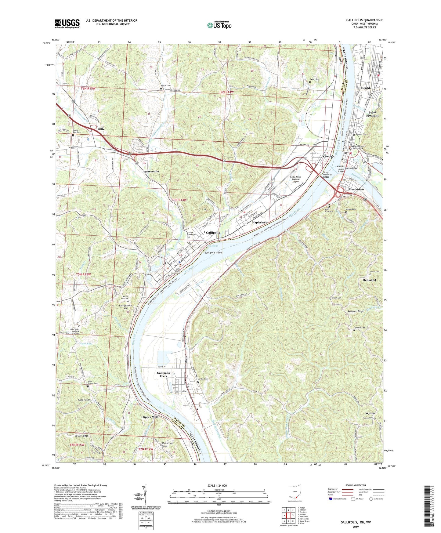
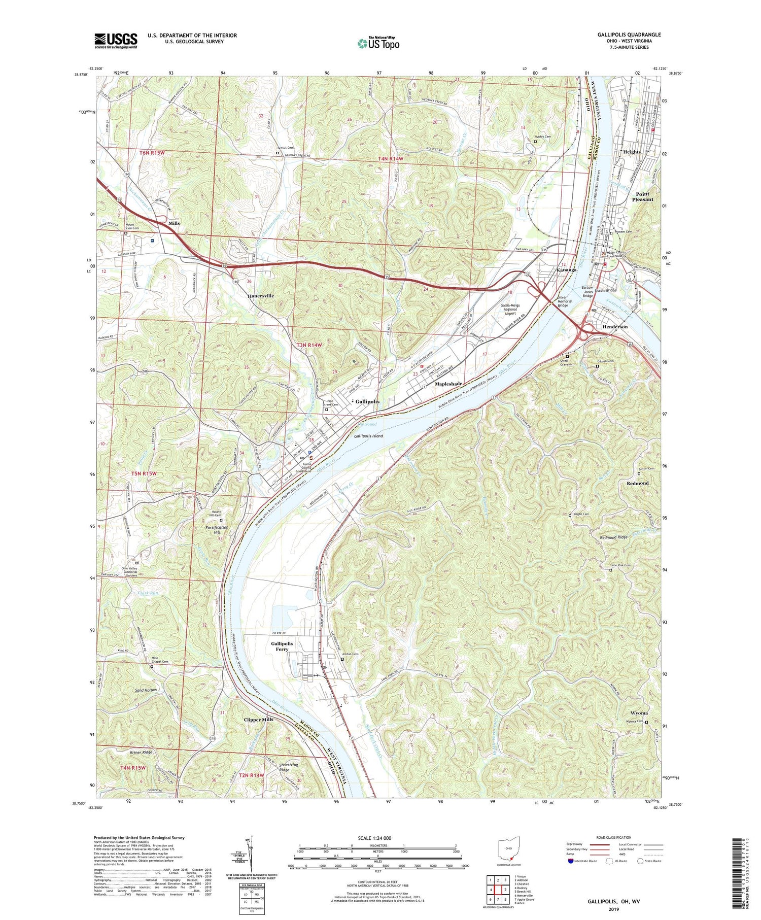
2019 topographic map quadrangle Gallipolis in the states of Ohio, West Virginia. Scale: 1:24000. Based on the newly updated USGS 7.5' US Topo map series, this map is in the following counties: Gallia, Mason. The map contains contour data, water features, and other items you are used to seeing on USGS maps, but also has updated roads and other features. This is the next generation of topographic maps. Printed on high-quality waterproof paper with UV fade-resistant inks.
Quads adjacent to this one:
West: Rodney
Northwest: Vinton
North: Addison
East: Beech Hill
Southeast: Arlee
South: Apple Grove
Southwest: Mercerville
Contains the following named places: Austin Cemetery, Baileys Landing, Bartow Jones Bridge, Beale, Beale Elementary School, Bethel Cemetery, Bethel Methodist Episcopal Church, Bobin Park, Bryans Run, Bush Spring, Byrd Blain Spring, Central Elementary School, Central School, Chickamauga Creek, Christ United Methodist Church, Church of Christ, Church of God, Church of the Nazarene, City of Point Pleasant, Clark Run, Cliffside Golf Club, Clipper Mills, Clipper Mills Post Office, Crooked Creek, Davis Hall, Doctor Samuel L Bossard Memorial Library, Drew Hatfield Spring, Elizabeth L Evans Waterfowl and Bird Sanctuary, Evans Heights, Evans Run, Fair Haven Methodist Church, Ferry Creek, Final Hour Church, First Baptist Church, First Church of God, First Presbyterian Church, Fort Randolph, Fortification Hill, French Art Colony Regional Multi-Arts Center, French City Church, Gallia Academy High School, Gallia County Childrens Home, Gallia County Courthouse, Gallia County Emergency Medical Services, Gallia County Fairgrounds, Gallia County Infirmary, Gallia County Junior Fairgrounds, Gallia County Sheriff's Office, Gallia-Meigs Regional Airport, Gallipolis, Gallipolis City Hall, Gallipolis City Park, Gallipolis Ferry, Gallipolis Ferry Census Designated Place, Gallipolis Ferry Post Office, Gallipolis Fire Department Station 1, Gallipolis Fire Department Station 2, Gallipolis Island, Gallipolis Police Department, Gallipolis Post Office, Gallipolis Public Square and Garden Lots Historic District, Gallipolis State Institute, Gatewood, George Creek, Gibson Cemetery, Gillispie Chapel, Gilmore Heights, Grace United Methodist Church, Grandview Estates, Green Acres, Hallidays Landing, Hanersville, Harmon Park, Haskins Memorial Park, Hedgewood, Heights, Henderson, Henderson Police Department, Henderson Post Office, Holzer Gallipolis Medical Center, Holzer Heliport, Holzer School of Nursing, John Gee African Methodist Episcopal Chapel, Jordan Cemetery, Jordan Church, Kanauga, Kanauga Census Designated Place, Kanauga Drive-In, Kanauga Post Office, Kanauga School, Kanawha River, Lawnview, Little Chickamauga Creek, Lone Oak Cemetery, Long Landing, Long Run, Maddy Cemetery, Mapleshade, Mapleshade Post Office, Mason County Convention and Visitors Bureau, Mason County Courthouse, Mason County Public Library, Mason County Sheriff's Office, Massick Spring, Meadow Look, Memorial Field, Mile Creek, Mill Creek, Mills, Mills Village, Mina Chapel, Mina Chapel Cemetery, Minnie Spears Spring, Molasses Run, Morris and Dorothy Haskins Ariel Theatre, Mound Hill Cemetery, Mount Zion Cemetery, Mount Zion Church, New Life Lutheran Church, Ohio State Highway Patrol - Gallipolis Patrol Post, Ohio Valley Christian School, Ohio Valley Memorial Gardens, Ohio Valley Visitors Center, Oldtown Creek, Orchard Hill, Ordnance Elementary School, Our House Museum, Paint Creek, Paint Creek Baptist Church, Pine Street Cemetery, Pioneer Cemetery, Pisgah Cemetery, Pleasant Valley Estates, Point Pleasant, Point Pleasant Intermediate School, Point Pleasant Middle School, Point Pleasant Police Department, Point Pleasant Post Office, Point Pleasant Primary School, Point Pleasant Volunteer Fire Department, Point Pleasant Volunteer Fire Department Substation, Redmond, Redmond Ridge, Riverby, Rocky Run, Saint Peters Episcopal Church, Salt Creek, Sand Hollow, Shadle Bridge, Silver Bridge, Silver Bridge Plaza Shopping Center, Silver Memorial Bridge, Smith Graveyard, Texas Road Wildlife Area, The Sound, Threemile Creek, Town and Country Estates, Town of Henderson, Township of Gallipolis, Tried Stone Baptist Church, Tu-Endie-Wei Point Pleasant Battle Monument State Park, Twomile Creek, Village of Gallipolis, Walkers Landing, Washington Elementary School, Wesleyan Holiness Academy, Wesleyan Holiness Bible College, Westbrook Village, Westminster Church, WGTR-FM (Gallipolis), Willow Branch, Willow Woods, WJEH Radio Tower, WJEH-AM (Gallipolis), Wyoma, Wyoma Cemetery, WZYI-FM (Point Pleasant), ZIP Code: 25515