MyTopo
Galloway Ohio US Topo Map
Couldn't load pickup availability
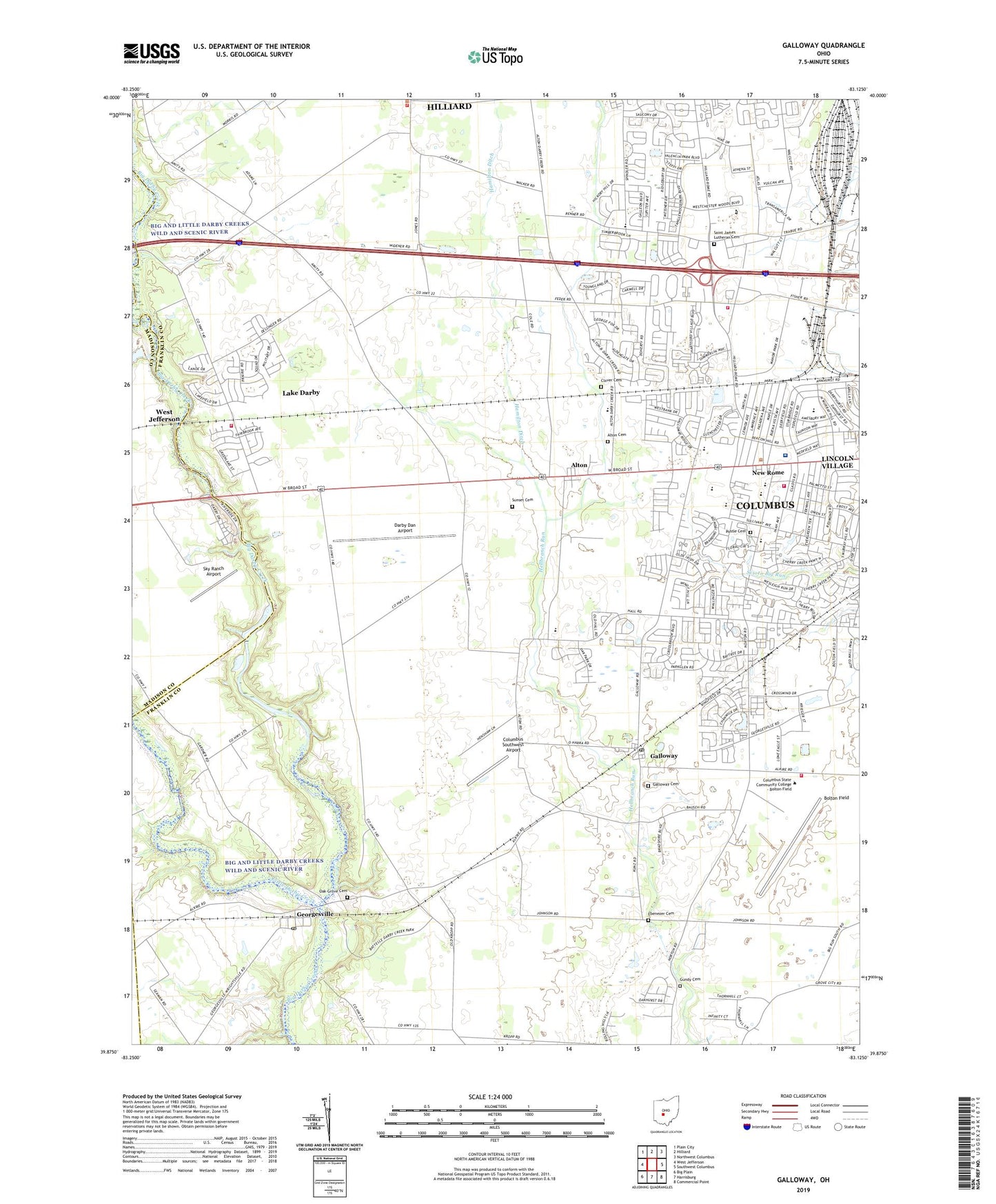
2019 topographic map quadrangle Galloway in the state of Ohio. Scale: 1:24000. Based on the newly updated USGS 7.5' US Topo map series, this map is in the following counties: Franklin, Madison. The map contains contour data, water features, and other items you are used to seeing on USGS maps, but also has updated roads and other features. This is the next generation of topographic maps. Printed on high-quality waterproof paper with UV fade-resistant inks.
Quads adjacent to this one:
West: West Jefferson
Northwest: Plain City
North: Hilliard
Northeast: Northwest Columbus
East: Southwest Columbus
Southeast: Commercial Point
South: Harrisburg
Southwest: Big Plain
Contains the following named places: Alton, Alton Cemetery, Alton Post Office, Alton Station, Alton-Hall Elementary School, Battelle Memorial Institute, Beacon of Hope Church of Christ in Christian Union, Big and Little Darby Creeks Wild and Scenic River, Bolton Field, Bolton Field Golf Course, Broadman Baptist Church, Brown Township House, Camp Ken-Jocket, Cedar Ridge Picnic Area, Cherry Creek Church of Christ, Clifton Chase, Clover Cemetery, Columbia Heights United Methodist Church, Columbus Division of Fire Station 26, Columbus Division of Fire Station 31, Columbus Southwest Airport, Concordia Lutheran Church, Conrail Buckeye Yards, Coventry, Darby Creek Metropolitan Park, Darby Dan Airport, Darby Plains, Ebenezer Cemetery, Edgewater, Epernay, Galloway, Galloway Cemetery, Galloway Post Office, Galloway Ridge, Galloway United Presbyterian Church, Georgesville, Georgesville Church of Christ in Christian Union, Georgesville Post Office, Glenchester, Great Oak, Green Countrie Park, Greene Countrie, Gundy Cemetery, Halloway, Hamilton Ditch, Hawthorn Loop Trail, Hickory Hills Golf Course, Hilliard Commons, Hilliard Green, Holy Spirit Fellowship Church, Indian Ridge Picnic Area, Lake Darby, Lake Darby Census Designated Place, Lake Darby Estates, Laurel Green, Lincoln Baptist Church, Lincoln Village, Lincoln Village Census Designated Place, Lincoln Village Plaza Shopping Center, Little Darby Creek, Little Darby Picnic Area, New Rome, Norton Junior High School, Norwich Township Fire Department Station 82, Oak Grove Cemetery, Oakhurst Country Club, Oakmont Village, OhioHealth Doctors Hospital, Post Oak Country Estates, Postle Cemetery, Prairie Township Fire Department Station 241 Headquarters, Prairie Township Fire Department Station 243, Prairie Township Hall, Prairie-Lincoln Elementary School, Prairie-Norton Elementary School, Quaker Hill, Robroy Estates, Rome, Saint Cecelia School, Saint Cecilia Catholic Church, Saint James Lutheran Cemetery, Saint James Lutheran Church, Saint James School, Saint Paul Lutheran Church, Shagbark Reservable Area, Silver Creek Dam, Sky Ranch Airport, Southwest Airport Industrial Park, Summerlyn, Sunset Cemetery, Sweetwater, The Meadows, The Village At Thornapple, Thomapple Country Club, Thornapple Grove, Thornapple Highlands, Timberbrook, Township of Prairie, Village Park, Walcutt Road Industrial Park, Westbend, Westchester, Westland High School, Westland Square Shopping Center, Westminster United Presbyterian Church, Westpointe Plaza Shopping Center, Westwoods Village, White Oak Reservable Area, ZIP Codes: 43119, 43228