MyTopo
Kitts Hill Ohio US Topo Map
Couldn't load pickup availability
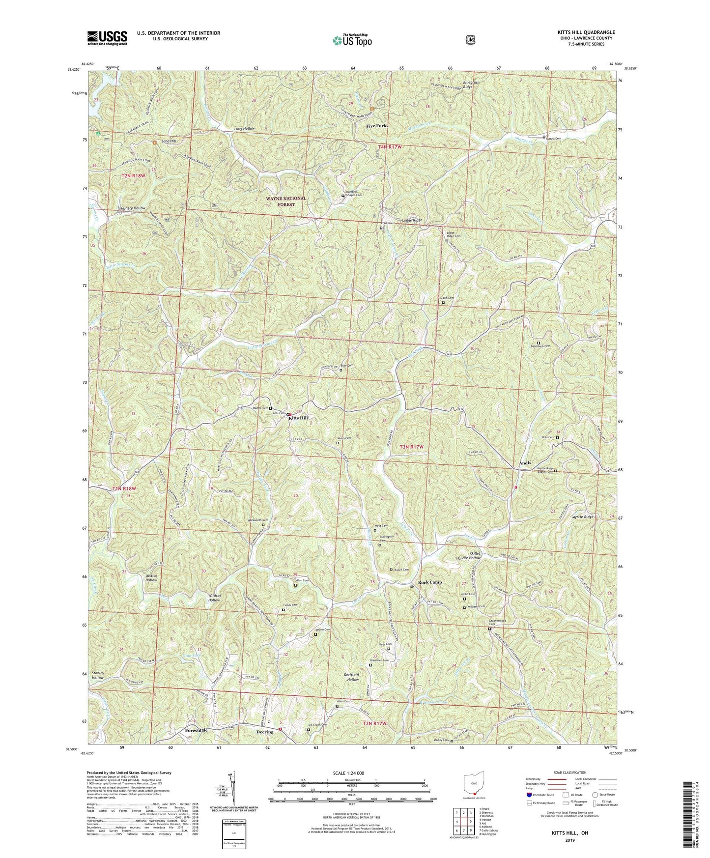
2019 topographic map quadrangle Kitts Hill in the state of Ohio. Scale: 1:24000. Based on the newly updated USGS 7.5' US Topo map series, this map is in the following counties: Lawrence. The map contains contour data, water features, and other items you are used to seeing on USGS maps, but also has updated roads and other features. This is the next generation of topographic maps. Printed on high-quality waterproof paper with UV fade-resistant inks.
Quads adjacent to this one:
West: Ironton
Northwest: Pedro
North: Sherritts
Northeast: Waterloo
East: Aid
Southeast: Huntington
South: Catlettsburg
Southwest: Ashland
Contains the following named places: Allen Cemetery, Andis, Andis Elementary School, Andis Post Office, Bald Knob, Bald Knob Cemetery, Bald Knob Church, Bazell Cemetery, Blair Cemetery, Bluegrass Ridge, Brammer Cemetery, Brammer Pond, Brammer Pond Dam, Buck Creek, Centenary Church, Cherryville, Cherryville Post Office, Currington Cemetery, Dearing Post Office, Deering, Deering Elementary School, Dog Fork, Edgemeade of Ohio Center, Fair Haven Lake Dam, Fields Cemetery, Five Forks, Forestdale, Forestdale Post Office, Fradd Cemetery, Gina Lake, Hackworth Cemetery, Hecla School, Hungry Hollow, Ice Creek Cemetery, Justice Hollow, Keys Cemetery, Kitts Cemetery, Kitts Hill, Kitts Hill Post Office, Lake Vesuvius, Lawrence County, Lawrence Township Fire Department Station 2, Lawrence Township Volunteer Fire Department Station 1 Headquarters, Leach Cemetery, Leatherwood Cemetery, Leatherwood Church, Little Storms Creek, Lodge Ridge, Lodge Ridge Cemetery, Long Hollow, Maddy Cemetery, Mamre Cemetery, Mamre Church, Manker, Manker Post Office, Markin Fork, Mays Cemetery, Melvin Cemetery, Myrtle Ridge, Myrtle Ridge Baptist Cemetery, Myrtle Ridge Church, Ned Fork, Oakland Chapel, Oakland Chapel Cemetery, Perry Township Volunteer Fire Department Station 1 Deering Headquarters, Rock Camp, Rock Camp Post Office, Rock Hill School, Ross Cemetery, Russell Cemetery, Sand Hill, Shelton Hollow, Skillet Handle Hollow, Skin Creek, Spring Branch, Stanley Hollow, Sugar Creek, Township of Lawrence, Triedstone Church, Turkey Fork, Union Church, Webb Cemetery, Wildcat Hollow, Williams Cemetery, ZIP Code: 45645