MyTopo
Northfield Ohio US Topo Map
Couldn't load pickup availability
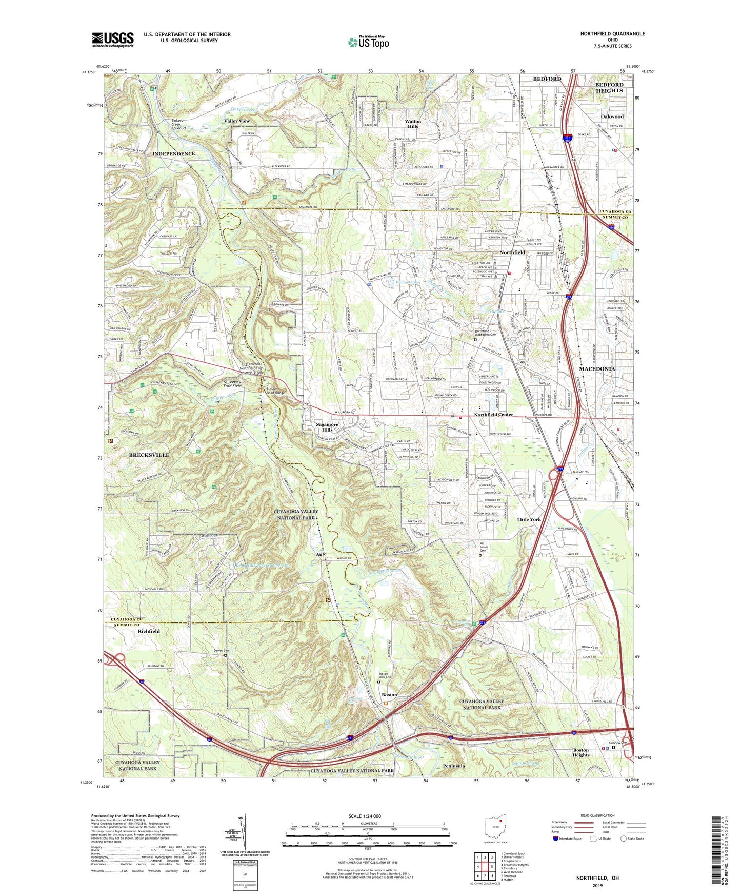
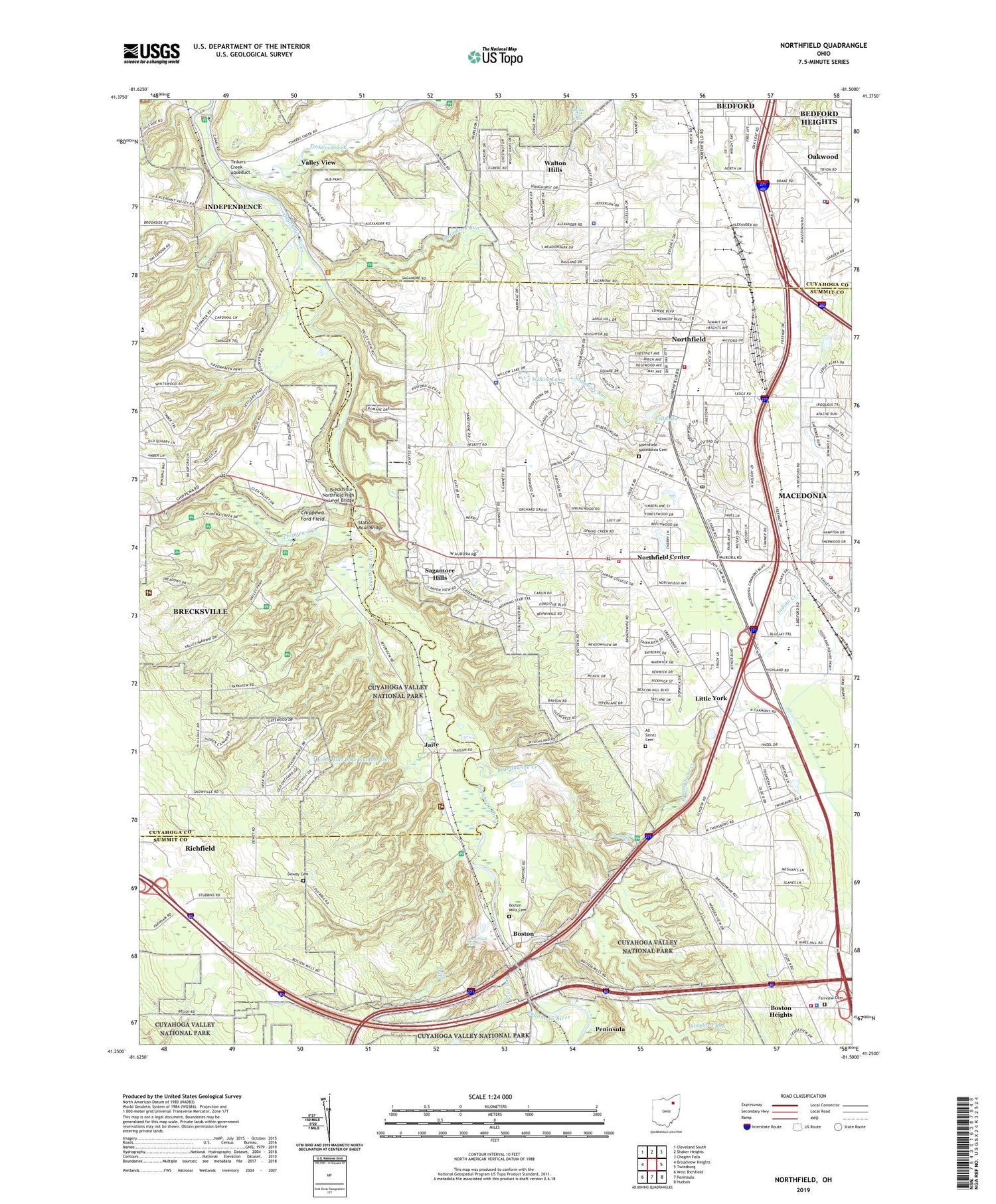
2019 topographic map quadrangle Northfield in the state of Ohio. Scale: 1:24000. Based on the newly updated USGS 7.5' US Topo map series, this map is in the following counties: Summit, Cuyahoga. The map contains contour data, water features, and other items you are used to seeing on USGS maps, but also has updated roads and other features. This is the next generation of topographic maps. Printed on high-quality waterproof paper with UV fade-resistant inks.
Quads adjacent to this one:
West: Broadview Heights
Northwest: Cleveland South
North: Shaker Heights
Northeast: Chagrin Falls
East: Twinsburg
Southeast: Hudson
South: Peninsula
Southwest: West Richfield
Contains the following named places: Alexander, All Saints Cemetery, Astorhurst Golf Course, Blue Hen Falls, Boston, Boston Heights, Boston Heights Fire Department, Boston Heights Police Department, Boston Hills Country Club, Boston Lock, Boston Mills Cemetery, Boston Post Office, Brandywine, Brandywine Creek, Brandywine Falls, Brecksville Nature Center, Brecksville Reservation, Brecksville Shopping Center, Brecksville Stables, Brecksville Station, Brecksville-Northfield High Level Bridge, Brentwood Ambulatory Care Center Heliport, Bridal Veil Falls, Buttermilk Falls, Capital Square Industrial Park, Chaffee, Chippewa Creek, Chippewa Creek Gorge Scenic Overlook, Chippewa Elementary School, Chippewa Ford Field, Chippewa Picnic Area, City of Brecksville, Coliseum Heliport, Cuyahoga Valley National Park, Dellwood Park, Dewey Cemetery, Echo Hills Lake Number One, Echo Hills Lake Number One Dam, Emmons Corner, Fairview Cemetery, Fell Lake, Freeway Industrial Park, Grannys Run, Harriet Keeler Memorial Picnic Area, Harriet Keeler Memorial Woods, Hawthornden State Hospital, Hermits Hollow Picnic Area, Highland Pointe Industrial Park, Indian Creek, Jaite, Jaite Mill Historic District, Jaite Post Office, Ledgewood Mobile Home Park, Lee Eaton Elementary School, Little York, Macedonia, Macedonia Fire Department, Meadows Picnic Area, Nordonia High School, Nordonia Middle School, Northcoast Behavioral Healthcare, Northfield, Northfield - Macedonia Cemetery, Northfield Center, Northfield Center Fire Department, Northfield Elementary School, Northfield Ledge Shopping Center, Northfield Park, Northfield Post Office, Northfield Square Shopping Center, Northfield Village Fire Department, Oak Grove Picnic Area, Oakwood, Oakwood Village Fire Department, Oakwood Village Hall, Oakwood Village Police Department, Ottawa Point Reserved Picnic Area, Plateau Picnic Area, Rushwood Elementary School, Sagamore Grove Picnic Area, Sagamore Hills, Sagamore Hills Hospital, Sagamore Hills Medical Center, Sagamore Hills Police Department, Sagamore Run, Sagamore Square Shopping Center, Sleepy Hollow Golf Course, South Park Post Office, Southpark, Stanford Run, Station Road Bridge, Strattons Heliport, Stumpy Basin, Tinkers Creek, Tinkers Creek Aqueduct, Township of Northfield Center, Township of Sagamore Hills, Turnpike Industrial Park, Village of Boston Heights, Village of Northfield, Village of Oakwood, Village of Walton Hills, Wallin Creek, Walton Hills, Walton Hills Park, Walton Hills Police Department, Walton Hills Village Hall, WBNX-TV (Akron), Wheelock, Willow Lake, WWWE-AM (Cleveland), WZAK-FM (Cleveland), ZIP Codes: 44056, 44067, 44141