MyTopo
Southeast Columbus Ohio US Topo Map
Couldn't load pickup availability
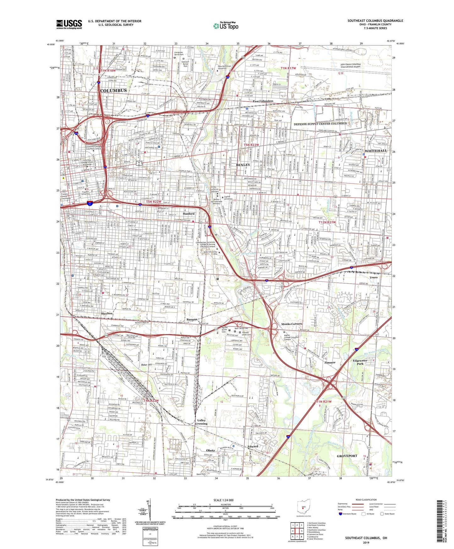
2019 topographic map quadrangle Southeast Columbus in the state of Ohio. Scale: 1:24000. Based on the newly updated USGS 7.5' US Topo map series, this map is in the following counties: Franklin. The map contains contour data, water features, and other items you are used to seeing on USGS maps, but also has updated roads and other features. This is the next generation of topographic maps. Printed on high-quality waterproof paper with UV fade-resistant inks.
Quads adjacent to this one:
West: Southwest Columbus
Northwest: Northwest Columbus
North: Northeast Columbus
Northeast: New Albany
East: Reynoldsburg
Southeast: Canal Winchester
South: Lockbourne
Southwest: Commercial Point
Contains the following named places: Academy Park, Agudas Achim School, Airport Commerce Park, Alum Creek, Alum Creek Office Center, Alum Crest School, American Addition Park, Amvet Village Park, Archie Griffin Stadium, Argus Park, Argyle-Woodland Run, Baker Hill, Bannon, Barack Park, Barnett Park, Beatty Park, Bernlohr Stadium, Berwick Park, Berwick Plaza Shopping Center, Beth Jacob Cemetery, Bexley, Bexley Square Shopping Center, Big Walnut, Blackburn Playground, Blacklick Creek, Bliss Run, Brentnell Park, Buckeye Junior High School, C B Griffin Park, Canini Park, Capital University, Capital University Historic District, Capitol Square, Cassady Park, Central Park, Childrens Hospital Heliport, City Center Mall Shopping Center, City of Bexley, City of Columbus, City of Whitehall, Columbus, Columbus Community Hospital, Columbus Motor Speedway, Columbus Near East Side Historic District, Columbus School for Girls, Creek Way Industrial Park, Crossroads East Shopping Center, DCSC Heliport, Deaf School Park, Defense Construction Supply Center, Defense Supply Center Columbus, Deshler Park, Discovery Industrial Park, Doneys, Dorrian Commons Park, Driving Park, East Broad Street Historic District, East Broad Street School, East Columbus, East Columbus Elementary School, East High School, East Town Street Historic District, Easthaven Park, Eastland Centre Shopping Center, Eastland Mall Shopping Center, Eastland Plaza Shopping Center, Eastland Square Shopping Center, Eastland Vocational School, Eastlawn Cemetery, Eastmoor, Eastmoor Academy, Eastmoor Junior High School, Eastwood Avenue School, Eddie Saunders Park, Edgewater Park, Edward, Edward Station School, Eleventh Avenue School, Elk Run Park, English Park, Evergreen Burial Park, Fairwood Industrial Park, Fairwood Park, Federal Industrial Park, Felton School, Fornof School, Frank Fetch Memorial Park, Franklin Commons, Franklin County Hospital, Franklin County Infirmary, Franklin Park, Fulton School, Garfield School, German Village Antique Mall Shopping Center, Grant Medical Center, Great Eastern Shoppers Mart Shopping Center, Great Eastern Shopping Center, Greater Columbus Antique Mall Shopping Center, Groveport, Groveport-Madison High School, Hamilton Hills Shopping Center, Hanford, Hanford Village Park, Hayden Park, Hebrew School, Heer Park, Heimandale School, Helsel Park, Heritage Park, Holy Cross School, Holy Rosary School, Holy Spirit School, Indian Mounds Park, Industrial Commons Industrial Park, James Road School, Jefferson Avenue Historic District, Jeffery Park, Jeffrey Courtyard, John Glenn Columbus International Airport, Johnson Memorial Park, Joseph Skilken and Company Heliport, Karns Park, Karson Playground, Keller Park, Kimberly Industrial Park, Kirkwood Park, Kline Clinic, Kobacher Park, Krumm Park, Lamby Park, Leader Square Shopping Center, Leonard School, Lincoln Memorial Hospital, Lincoln Park, Livingston Avenue Medical Center, Livingston Court Shopping Center, Livingston Park, Maloney Park, Marion Square Industrial Park, Marion-Franklin High School, Marion-Franklin Park, Mason Run, Mayme Moore Park, Memory Lane Industrial Park, Millbrook Park, Milo, Milo School, Moeler Park, Monroe Junior High School, Mount Vernon Plaza Shopping Center, Munks Corners, Napoleon Park, Nationwide Children's Hospital, Natural Resources Park, Naval Air Facility Columbus, Nelson Park, New Agudas Achim Cemetery, New Indianola Historic District, Norton Field, Norton Field Playground, Obetz, Obetz Cemetery, Ohio Building Authority Heliport, Ohio Exposition Center, Palsgrove Park, Pinecrest School, Rainbow Park, Refugee Industrial Park, Roosevelt Park, Roosevelt School, Roseland, Russell Page Sculpture Garden, Saint Anns Hospital, Saint Anthony Medical Center Heliport, Saint Anthonys Mercy Hospital, Saint Catharines School, Saint Charles Seminary, Saint Dominic School, Saint Johns School, Saint Josephs Academy, Saint Leo School, Saint Marys School, Saint Patricks School, Saint Peters School, Saint Philip the Apostle School, Saint Thomas the Apostle School, Schiller Park, Schlee Brewery Historic District, Scioto Trail Park, Select Specialty Hospital - Columbus South, Shepard, Shepard School, Smith Road School, South Columbus Airport, South Drive-In, South High School, Southeast Christian Academy, Southeast Lions Park, Southern Ohio College, Southern Pines Park, Southfield Shopping Center, Southgate Park, Southland Mall Shopping Center, Southwood Park, Spring Lakes, Steelton, Stockbridge Park, The Columbus Academy, The Courtyard, The Ohio State University Hospitals East, Third Street School, Three Rivers Park, Tifereth Israel Cemetery, Town and Country Shopping Center, Truro, Turkey Run, Valley Crossing, Watkins School, WBNS Radio Towers, WBNS-AM (Columbus), Weinland Park, Whitehall, Willis Park, Windsor Park, Wolfe Park, WTVN Radio Towers, WWIU Radio Towers, Zimmer, ZIP Codes: 43201, 43203, 43205, 43206, 43207, 43209, 43227