MyTopo
Wheelersburg Ohio US Topo Map
Couldn't load pickup availability
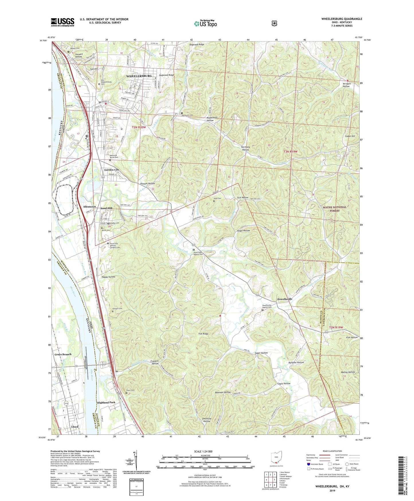
2019 topographic map quadrangle Wheelersburg in the states of Ohio, Kentucky. Scale: 1:24000. Based on the newly updated USGS 7.5' US Topo map series, this map is in the following counties: Scioto, Greenup, Lawrence. The map contains contour data, water features, and other items you are used to seeing on USGS maps, but also has updated roads and other features. This is the next generation of topographic maps. Printed on high-quality waterproof paper with UV fade-resistant inks.
Quads adjacent to this one:
West: Portsmouth
Northwest: New Boston
North: Minford
Northeast: South Webster
East: Pedro
Southeast: Ironton
South: Greenup
Southwest: Load
Contains the following named places: Able Medical Transport, Allentown, Angel Hollow, Ball School, Blair Quarry, Brick Union Church, Burkes Landing, Cadot Hill, Chandlers Run, Coyle Hollow, Crestview Park, Dark Lick School, Dogwood Ridge School, Dold Cemetery, Elm Grove School, Empire School, Feurt Cemetery, Floral Hills Memory Gardens Cemetery, Folsoms Landing, Franklin Furnace, Franklin Furnace Landing, Franklin Hollow, Garden City, Gerlach Cemetery, Germany Hollow, Germany Hollow Church, Goose Creek, Grays Branch, Grays Branch School, Green Township School, Green Township Volunteer Fire Department Station 2, Greenup Locks and Dam, Happy Hollow, Hayport School, Highland Park, Hillcrest Childrens Home, Irish Hollow, Junior Bridge School, Lick Run, Lick Run Lick Run, Lick Run School, Lloyd Census Designated Place, Memorial Burial Park, Mount Carmel Church, North Fork Lick Run, Nurse Cemetery, Old Dutch Cemetery, Old Wheelersburg Cemetery, Pine Creek, Pine Creek Baptist Cemetery, Pine Creek Church, Pitch Branch, Poplar Fork Pine Creek, Porter Township Emergency Rescue Association, Porter Township Fire Department, Possum Hollow, Powellsville, Powellsville Baptist Cemetery, Powellsville Post Office, Prestons Landing, Railpike Hollow, Rawley Cemetery, Riepenhoff Hollow, Sager Hollow, Saint John Lutheran Church, Salladay Cemetery, Sand Hill, Scioto Ambulance District Squad 9, Sheldon Run, Slash Branch, Smithline Hollow, Sperry Fork, Stewart Hollow, Sugar Camp Creek, Sugarcamp Branch, Sun Hill, Terrapin Hollow, Tick Hollow, Tick Ridge, Township of Green, Township of Porter, Township of Vernon, Upper Lick Run School, Vernon Township Fire Station 1, Wheelersburg, Wheelersburg Census Designated Place, Wheelersburg Elementary School, Wheelersburg High School, Wheelersburg Post Office, ZIP Codes: 45629, 45694