MyTopo
Tillamook Head Oregon US Topo Map
Couldn't load pickup availability
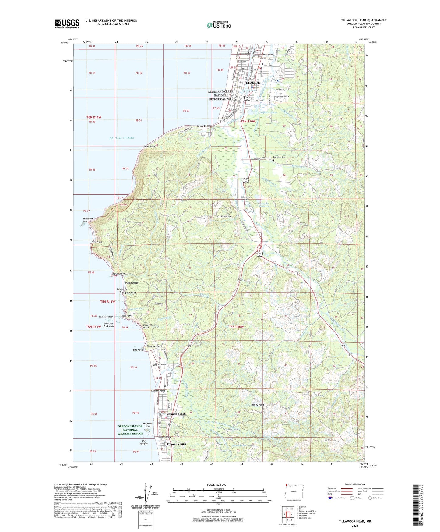
2020 topographic map quadrangle Tillamook Head in the state of Oregon. Scale: 1:24000. Based on the newly updated USGS 7.5' US Topo map series, this map is in the following counties: Clatsop. The map contains contour data, water features, and other items you are used to seeing on USGS maps, but also has updated roads and other features. This is the next generation of topographic maps. Printed on high-quality waterproof paper with UV fade-resistant inks.
Quads adjacent to this one:
West: Tillamook Head OE W
North: Gearhart
Northeast: Olney
East: Necanicum Junction
Southeast: Soapstone Lake
South: Arch Cape
Contains the following named places: Bailey Point, Bald Mountain, Bald Point, Bear Valley, Beerman Creek, Ben Holladay Post Office, Bird Point, Bird Rocks, Broadway Middle School, Broadway Park Boat Ramp, Cannon Beach, Cannon Beach City Hall, Cannon Beach Elementary, Cannon Beach History Center and Museum, Cannon Beach Junction, Cannon Beach Library, Cannon Beach Municipal Court, Cannon Beach Police Department, Cannon Beach Post Office, Cannon Beach Public Works, Cannon Beach Rural Fire Protection District, Cannon Beach Sewage Treatment Plant, Cannon Beach Trail, Cannon Beach Water Treatment Plant, Canyon Creek, Cartwright Park Boat Ramp, Central School, Chapman Beach, Chapman Point, Chapman Ponds, Church of Jesus Christ of Latter Day Saints, Circle Creek, City of Cannon Beach, City of Seaside, Clark's Mountain, Coaster Theatre, Crescent Beach, Crescent Creek, Ecola Creek, Ecola Point, Ecola State Park, Elmer Feldenheimer Forest Reserve, Evergreen Cemetery, Faith Lutheran Church, Haystack Hill State Park, Haystack Rock, Holladay, Hoover Spring, Indian Beach, Indian Creek, Indian Point, John Yeon State Park, Johnson Creek, Klootchie Creek, Klootchy Creek County Campground, Klootchy Creek County Park Boat Ramp, Kramer Point, KSWB - AM, Les Shirley Park, Lewis and Clark Salt Cairn Historic Monument, Little Muddy Creek, Logan Creek, MacLaren Forestry Camp, Mantel Lake, Medix Ambulance Service, Meyer Creek, Necanicum Guard Station, Necanicum Picnic Area, North Fork Ecola Creek, Our Saviours Lutheran Church, Peris Post Office, Providence Seaside Hospital, Providence Seaside Hospital Heliport, Quatat Marine Park Boat Launch, Rippet Mountain, Riverside Lake, Salmon Creek, Sea Lion Rock, Sea Lion Rock Arch, Seaside, Seaside City Hall, Seaside Civic and Convention Center, Seaside Division, Seaside Fire and Rescue, Seaside Golf Course, Seaside Heights Elementary School, Seaside House Post Office, Seaside Lumber Company, Seaside Municipal Court, Seaside Museum and Historical Society, Seaside Police Department, Seaside Post Office, Seaside Public Libarary, Seaside Public Works, Seaside Reservoir, Seaside Water Treatment Plant, Shangrila Creek, Skibbereen Bridge, Submarine Rock, Sunset Beach, Surf, The Needles, Tillamook Head, Tillangora Creek, Volmer Creek, Waterfall Creek, West Fork Ecola Creek, West Point, Williamson Creek, ZIP Code: 97110