MyTopo
Yachats Oregon US Topo Map
Couldn't load pickup availability
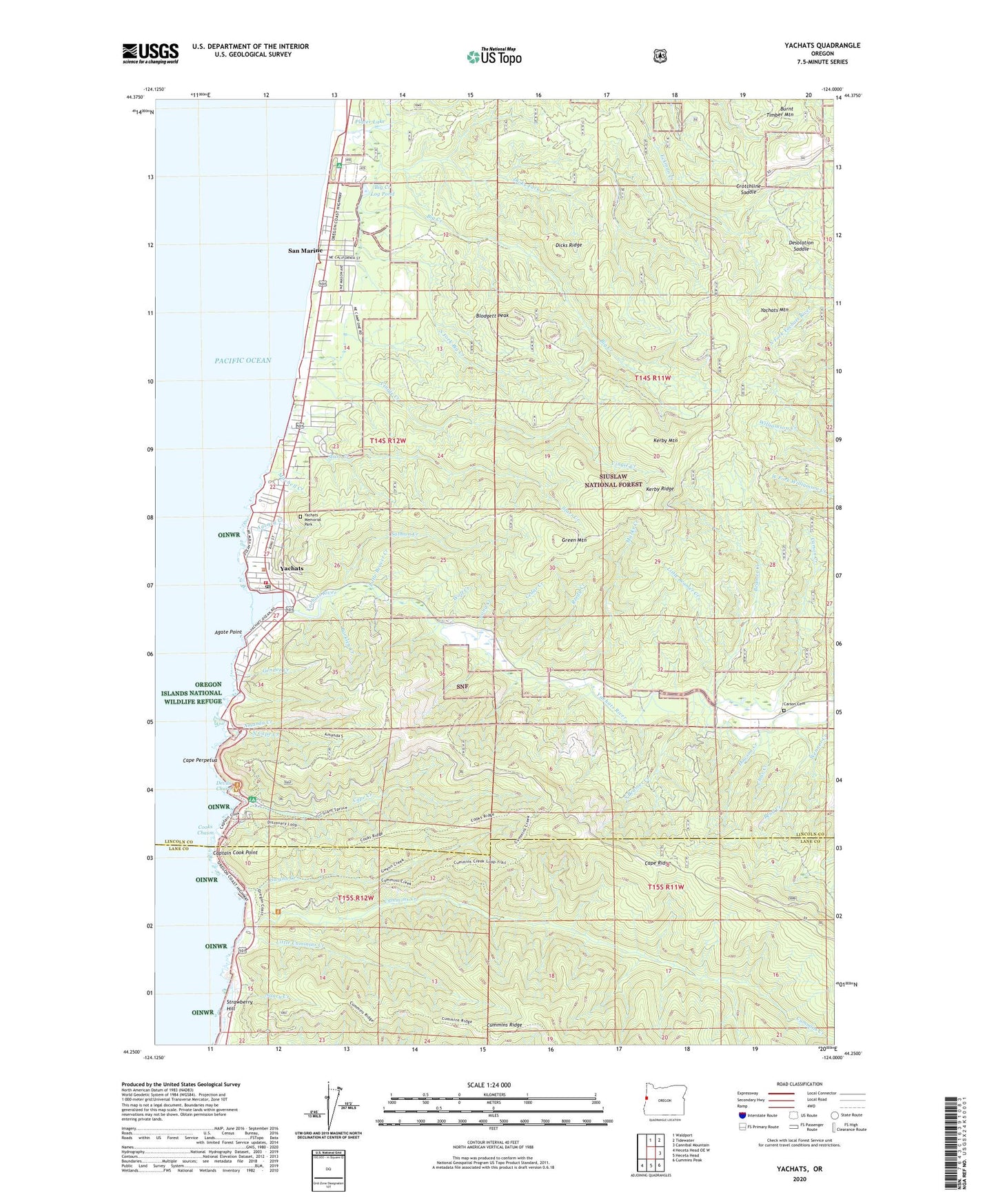
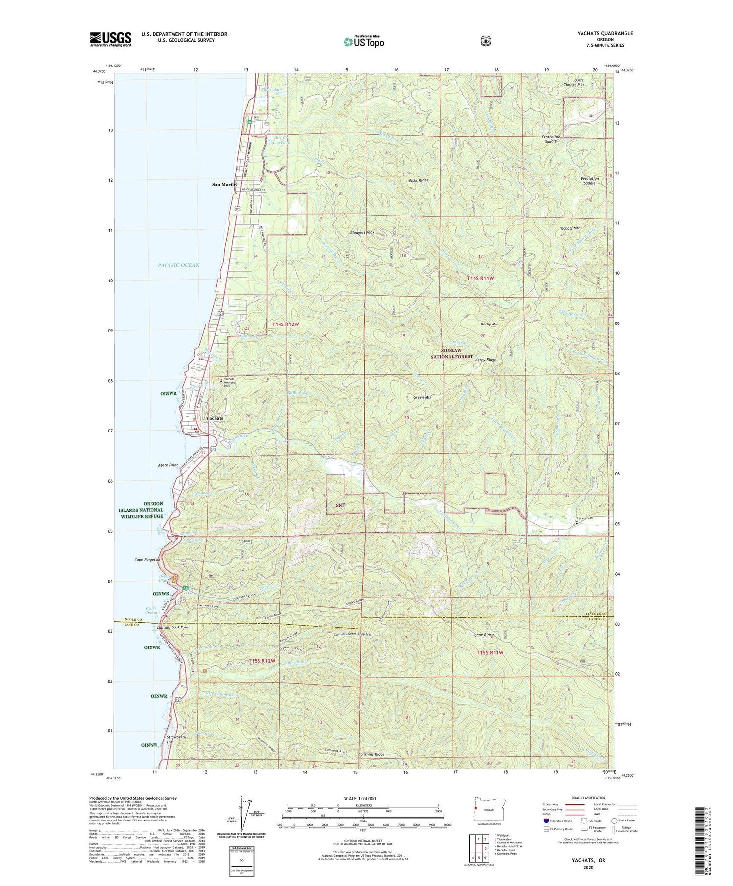
2020 topographic map quadrangle Yachats in the state of Oregon. Scale: 1:24000. Based on the newly updated USGS 7.5' US Topo map series, this map is in the following counties: Lincoln, Lane. The map contains contour data, water features, and other items you are used to seeing on USGS maps, but also has updated roads and other features. This is the next generation of topographic maps. Printed on high-quality waterproof paper with UV fade-resistant inks.
Quads adjacent to this one:
North: Waldport
Northeast: Tidewater
East: Cannibal Mountain
Southeast: Cummins Peak
South: Heceta Head
Southwest: Heceta Head OE W
Contains the following named places: Agate Point, Agency Creek, Amanda Creek, Amanda's Statue, Amanda's Trail, Angell Job Corps Center, Barkley Creek, Beamer Creek, Bend Creek, Big Creek, Big Creek Log Pond, Blodgett Peak, Blodgett Work Center, Camp Angell, Camp One, Cape Creek, Cape Perpetua, Cape Perpetua Recreation Site, Cape Perpetua Special Interest Area, Cape Perpetua Visitor Center, Captain Cook Point, Carson Cemetery, Carson Creek, Cedar Creek, City of Yachats, Clear Creek, Cleft of the Rock Cape Perpetua Lighthouse, Cooks Chasm, Crotchline Saddle, Cummins Creek, Cummins Creek Wilderness, Dawson Creek, Desolation Saddle, Devils Churn, Dicks Fork, Dicks Ridge, Fourmile Camp, Gender Creek, Green Mountain, Gregory Creek, Gwynn Creek, Kerby Mountain, Kerby Ridge, Little Beamer Creek, Little Beaver Creek, Little Cummins Creek, Long Creek, Marks Creek, Mitchell Creek, Nancy Creek, Neptune State Park, North Cape Creek, Placer Lake, Reedy Creek, Restless Waters Trailhead, Reynolds Creek, Reynoldsville, Salmon Creek, San Marine, San Marine Census Designated Place, San Marine State Park, Smelt Sands State Recreation Site, South Beamer Creek, South Fork Big Creek, South Lincoln Ambulance Service, Spring Creek, Starr Creek, Strawberry Hill, Strawberry Hill Picnic Area, Tillicum Beach, Tillicum Beach Recreation Site, Vingie Creek, Wenner Creek, Wolf Creek, Yachats, Yachats City Hall, Yachats Memorial Park Cemetery, Yachats Mountain, Yachats Municipal Court, Yachats Ocean Road State Natural Site, Yachats Post Office, Yachats Public Works, Yachats Purchase Unit, Yachats River, Yachats Rural Fire Protection District South Station, Yachats Sewage Treatment Plant, Yachats State Recreation Area, Yachats Water Treatment Plant, ZIP Code: 97498