MyTopo
Fayette City Pennsylvania US Topo Map
Couldn't load pickup availability
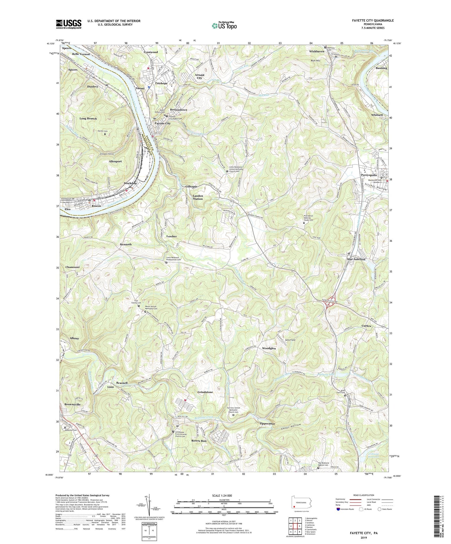
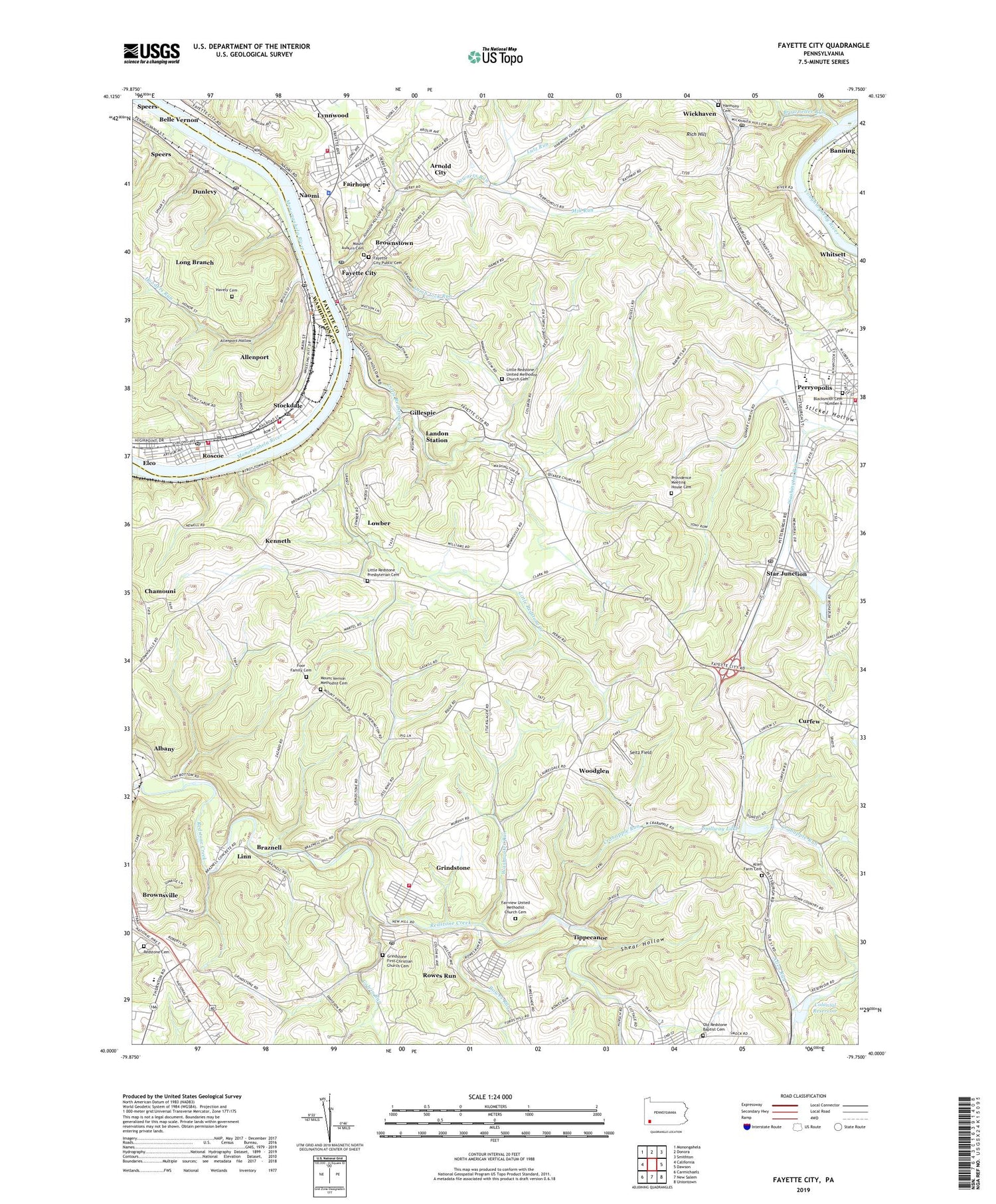
2019 topographic map quadrangle Fayette City in the state of Pennsylvania. Scale: 1:24000. Based on the newly updated USGS 7.5' US Topo map series, this map is in the following counties: Fayette, Washington. The map contains contour data, water features, and other items you are used to seeing on USGS maps, but also has updated roads and other features. This is the next generation of topographic maps. Printed on high-quality waterproof paper with UV fade-resistant inks.
Quads adjacent to this one:
West: California
Northwest: Monongahela
North: Donora
Northeast: Smithton
East: Dawson
Southeast: Uniontown
South: New Salem
Southwest: Carmichaels
Contains the following named places: Albany, Allen Farm Cemetery, Allenport, Allenport Hollow, Allenport Post Office, Allenport Volunteer Fire Department Station 40, Arnold City, Arnold City Census Designated Place, Banning, Blacksmith Cemetery Number 6, Borough of Allenport, Borough of Dunlevy, Borough of Fayette City, Borough of Perryopolis, Borough of Roscoe, Borough of Stockdale, Braznell, Browneller Run, Brownstown, Central High School, Chamouni, Colonial Dam Number One, Colonial Dam Number Three, Colonial Dock, Colonial Reservoir, Colvin Run, Crabapple Dam, Crabapple Run, Curfew, Downers Run, Dunlevy, Dunlevy Post Office, Elco, Fairhope, Fairhope Census Designated Place, Fairview Church, Fairview United Methodist Church Cemetery, Fayette City, Fayette City Post Office, Fayette City Public Cemetery, Fayette City Volunteer Fire Company Station 17, Foor Family Cemetery, Franklin School, Frazier High School, Gillespie, Grindstone, Grindstone Census Designated Place, Grindstone First Christian Church Cemetery, Grindstone Post Office, Grindstone Volunteer Fire Department Station 19, Grindstone-Rowes Run Census Designated Place, Harmony Cemetery, Havely Cemetery, Hooders Run, Jefferson School, Kenneth, Lamb Lick Run, Landon Station, Linn, Little Redstone Church, Little Redstone Creek, Little Redstone Presbyterian Cemetery, Little Redstone Presbyterian Church, Little Redstone School, Little Redstone United Methodist Church Cemetery, Long Branch, Lowber, Lutz Run, Lynn, Lynnwood, Madison High School, Marion High School, Mill Run, Mount Auburn Cemetery, Mount Hebron Church, Mount Tabor Church, Mount Union School, Mount Vernon Methodist Cemetery, Naomi, Naomi Census Designated Place, Old Redstone Baptist Cemetery, Perry Elementary School, Perry Township Volunteer Fire Department Station 32, Perryopolis, Providence Meeting House Cemetery, Quaker Church, Redstone, Redstone Cemetery, Rich Hill, Roscoe, Roscoe Post Office, Roscoe Volunteer Fire Department Station 16, Rowes Run, Rowes Run Census Designated Place, Seitz Field, Shear Hollow, Smock Volunteer Fire Company Station 36, Spillway Lake, Star Junction, Star Junction Census Designated Place, Star Junction Number One Dam, Star Junction Number Two Dam, Star Junction Post Office, Star Junction Reservoir, Stockdale, Stockdale Post Office, Stockdale Volunteer Fire Department Station 17, Tippecanoe, Tippie Canoe, Township of Brownsville, Township of Jefferson, Township of Washington, Troytown, Washington Township Volunteer Fire Company Station 42, Washwater Run, West Point School, Whitsett, Wickhaven, Wickhaven Post Office, Woodglen, ZIP Codes: 15412, 15432, 15438, 15442, 15473, 15477, 15482, 15483, 15492