MyTopo
Shamokin Pennsylvania US Topo Map
Couldn't load pickup availability
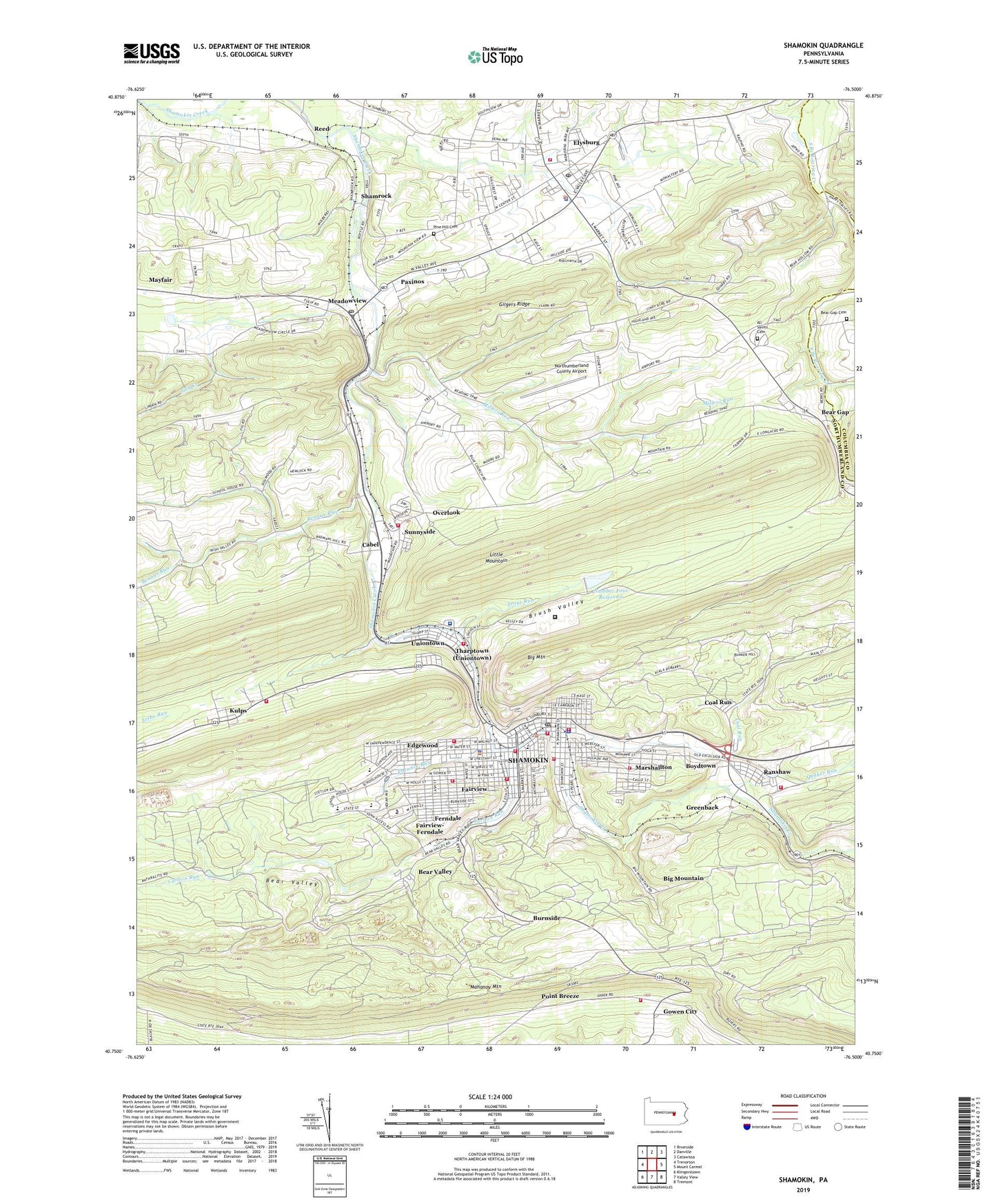
2019 topographic map quadrangle Shamokin in the state of Pennsylvania. Scale: 1:24000. Based on the newly updated USGS 7.5' US Topo map series, this map is in the following counties: Northumberland, Columbia. The map contains contour data, water features, and other items you are used to seeing on USGS maps, but also has updated roads and other features. This is the next generation of topographic maps. Printed on high-quality waterproof paper with UV fade-resistant inks.
Quads adjacent to this one:
West: Trevorton
Northwest: Riverside
North: Danville
Northeast: Catawissa
East: Mount Carmel
Southeast: Tremont
South: Valley View
Southwest: Klingerstown
Contains the following named places: All Saints Cemetery, AREA Services Emergency Medical Services Station 90, Ash Grove Church, Bar Mac Ramp Station, Bear Gap, Bear Gap Cemetery, Bear Gap Tabernacle, Bear Valley, Bennys Run, Bethel Chapel, Big Mountain, Boydtown, Boyers Knob Lookout Tower, Brady Fire Company Station 150, Brush Valley, Buck Creek, Burnside, Cabel, Carbon Run, Carbon Run Breaker Station, Carmelite Monastery, City of Shamokin, Clarks Grove Church, Coal Run, Coal Township Fire Department - Fairview Fire Company Station 140, Coal Township Police Department, Crowl Post Office, D and Z Ramp Station, East Cameron Township Fire Company Station 350, East End Hose and Fire Company Station 120, Edgewood, Edgewood Census Designated Place, Edgewood Gun Club, Elysburg, Elysburg Census Designated Place, Elysburg Fire Company Station 170, Elysburg Post Office, Fairview, Fairview-Ferndale Census Designated Place, Ferndale, Forest Hills Fire Company Station 160, Friendship Fire Engine and Hose Company Station 10, Furnace Run, Gilgers Ridge, Glen Burn Colliery Station, Gowen City, Grace Chapel, Greenback, Helfricks Heliport, Hern Junction, Independence Hose Company Station 40, Jacob Church, Jepkos Three Ponds Golf Course, Kemp Stadium, Kulps, Liberty Hose Company 2 Station 20, Lick Creek, Lincoln School, Mahanoy Mountain, Maine Fire Company Station 110, Marshallton, Marshallton Census Designated Place, Meadowview, Millers Run, Northumberland County Airport, Number Four Reservoir, Number One Reservoir, Oak Grove Church, Our lady of Lourdes High School, Overlook, Overlook Fire Company Station 290, Paxinos, Paxinos Post Office, Pine Hill Cemetery, Point Breeze, Quaker Run, Ralpho Township Police Department, Ranshaw, Ranshaw Census Designated Place, Ranshaw Post Office, Ranshaw Washery Station, Reed, Rescue Hose Company Station 30, Saint Pauls Church, Saint Peters Church, Shamokin, Shamokin Area Community Hospital, Shamokin Filler Plant Station, Shamokin Police Department, Shamokin Post Office, Shamokin Rod and Gun Club, Shamrock, Snufftown, State Correctional Institution Coal Township, Stevens School, Sunnyside, Tharptown (Uniontown) Census Designated Place, Township of Coal, Township of Ralpho, Trout Run, Trout Run Dam Number Four, Union Fire Company Station 130, Uniontown, Washington School, Weigh Scale Tipple Station, Weigh Scales, West End Fire Company Station 50, Whaleback, WISL-AM (Shamokin), WSPI-FM (Shamokin), ZIP Codes: 17824, 17860, 17866