MyTopo
Bristol Rhode Island US Topo Map
Couldn't load pickup availability
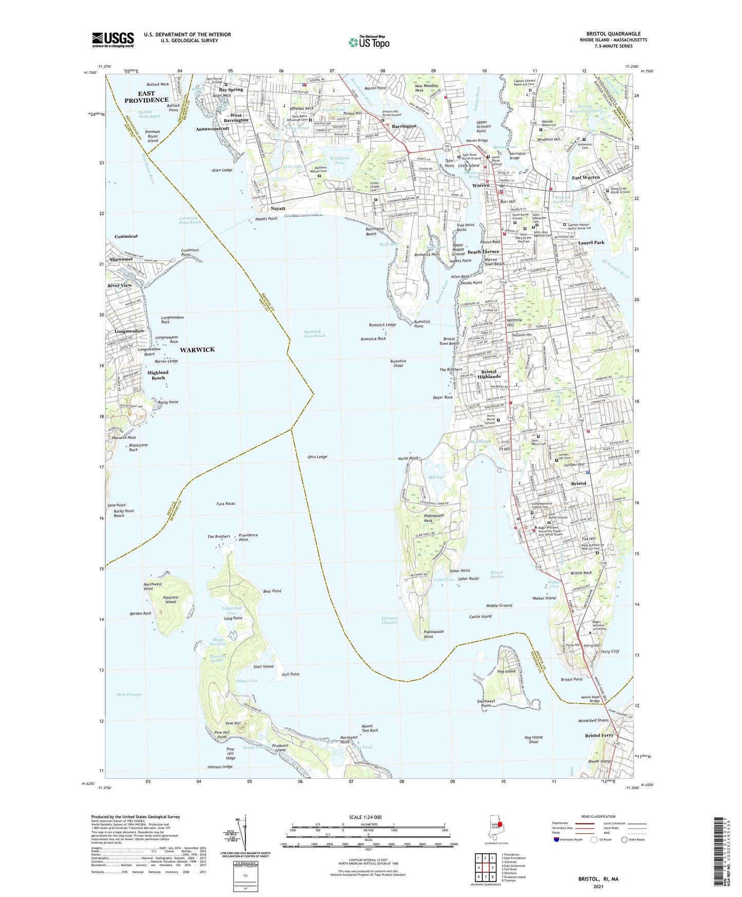
2021 topographic map quadrangle Bristol in the state of Rhode Island. Scale: 1:24000. Based on the newly updated USGS 7.5' US Topo map series, this map is in the following counties: Bristol, Newport, Kent, Providence. The map contains contour data, water features, and other items you are used to seeing on USGS maps, but also has updated roads and other features. This is the next generation of topographic maps. Printed on high-quality waterproof paper with UV fade-resistant inks.
Quads adjacent to this one:
West: East Greenwich
Northwest: Providence
North: East Providence
Northeast: Somerset
East: Fall River
Southeast: Tiverton
South: Prudence Island
Southwest: Wickford
Contains the following named places: Adams Point, Allen Ledge, Allen Neck, Allen Rock, Allin Burial Ground, Annawomscutt, Annawomscutt Brook, Barden Rock, Barren Ledge, Barrington, Barrington Beach, Barrington Bridge, Barrington Census Designated Place, Barrington Civic Center Historic District, Barrington High School, Barrington Middle School, Barrington River, Barrington Yacht Club, Bay Island Park, Bay Spring, Beach Terrace, Bear Point, Belcher Cove, Blackstone Rock, Blithewold Mansion and Gardens, Boystown Fly-in-Ranch, Brickyard Pond, Bristol, Bristol Census Designated Place, Bristol County, Bristol Ferry, Bristol Golf Club, Bristol Harbor, Bristol Highlands, Bristol Neck, Bristol Playground, Bristol Point, Bristol Shopping Center, Bristol Town Beach, Bristol Town Common, Bristol Township, Bristol Waterfront Historic District, Bristol Yacht Club, Bullock Point, Bullock Point Reach, Burr Hill, Byfield School, Captain Nathan Munro Junior Lot, Carousel Nursery, Castle Island, Child Street School, Coggeshall Cove, Coggeshall Farm Museum, Colt State Park, Colt-Andrews School, Congregational Church Cemetery, Conimicut Point, Conimicut Point Park, Conimicut Point Reach, Crescent Park, Crescent Park Carousel, Daniel Cole Burial Ground, Deep Hole, Deyer Rock, Drown Cove, East Burial Ground, East Warren, Echo Lake, Entrance Channel, Fairlawn Golf Course, Ferry Cliff, Ferry Hill, Forest Chapel Cemetery, Fork Rocks, Fort Hill, Fox Hill, George T Baker School, Guiteras School, Gull Point, Halfmile Hill, Hampden Meadows School, Heath Brook, Highland Beach, Hog Island, Hog Island Shoal, Holy Angels Church Education Center, Hope Street Shopping Center, Hugh Cole School, Hyde Hole, Jacobs Point, Jenny Pond, Johnson Ledge, Juniper Hill, Juniper Hill Cemetery, Kelleys Ferry, Kickemuit Cemetery, Kickemuit Middle School, Kids Quarters Pre-School, Kings Kids Elementary School, Laurel Park, Leander Peck Memorial School, Little Island, Little Peoples Nursery, Long Point, Longmeadow, Longmeadow Beach, Longmeadow Rock, Main Street School, Maple Avenue School, Mark Anthony De Wolf Lot Cemetery, Martin Point, Martins Ferry, Massasoit Spring, Matthew Watson Cemetery, Maxfields Corner, Middle Ground, Mill Gut, Mill Pond, Mount Hope Bridge, Mount Hope High School, Mount Tom Rock, Mussachuck Creek, Musselbed Shoals, Nag Creek, Nag Pond, Narragansett Brick Works, Nayatt, Nayatt Landing, Nayatt Point, Nayatt Point Lighthouse, Nayatt School, North Burial Ground, North Point, Northeast Point, Northwest Point, Obadiah Bowen Lot, O'Bannon Mill, Ocean State Plaza Shopping Center, Ohio Ledge, Old Mill Creek, Oliver School, Our Lady of Mount Carmel School, Palmer River, Patience Island, Peck Center Playground, Penivs Rock, Phebes Neck, Pine Hill, Pine Hill ledge, Pine Hill Ledge, Pine Hill Point, Pocasset Heights, Pomham Rocks Island, Popasquash Neck, Popasquash Point, Potter Cove, Prince Hill, Prince Pond, Prince's Hill Burial Ground, Providence Point, Prudence Island Ferry, Raggedy Ann Nursery School, Reynolds School, Rhode Island Country Club, Rhode Island Soldiers Home, River View, Rock Point Amusement Park, Rockwell Park, Rockwell School, Rocky Point, Rocky Point Amusement Resort, Rocky Point Beach, Roger Williams University, Rumstick Ledge, Rumstick Neck, Rumstick Neck Reach, Rumstick Point, Rumstick Rock, Rumstick Shoal, Saint Alexander Cemetery, Saint Andrews School, Saint Columbans Seminary, Saint Elizabeths School, Saint Jean Baptiste Cemetery, Saint Marie Delcompo Cemetery, Saint Mary of the Bay Cemetery, Saint Mary's Cemetery, Sand Point, Sea Side Nursery, Sheep Pen Cove, Sheep Pen Swamp, Shell Island, Silver Creek, Smith Cove, South Burial Ground, South Warren, Southwest Point, Sowams, Story Land Preschool, The Brothers, Town of Barrington, Town of Bristol, Town of Warren, Tree Point Rocks, Tyler Point, Tyler Point Burial Ground, Upper Grinnell Point, Upper Middle Ground, Uptown Creek, Usher Cove, Usher Point, Usher Rocks, Veterans Memorial Park, Veterans Park, Volpes Pond, Walker Cove, Walker Creek, Walker Island, Walley Park, Walley School, Warren, Warren Bridge, Warren Common, Warren Reservoir, Warren Reservoir Lower Dam, Warren Reservoir Upper, Warren Reservoir Upper Dam, Warren River, Warren Town Beach, Warrens Waterfront Historic District, West Barrington, Windmill Hill, ZIP Codes: 02806, 02809, 02885