MyTopo
Camden South South Carolina US Topo Map
Couldn't load pickup availability
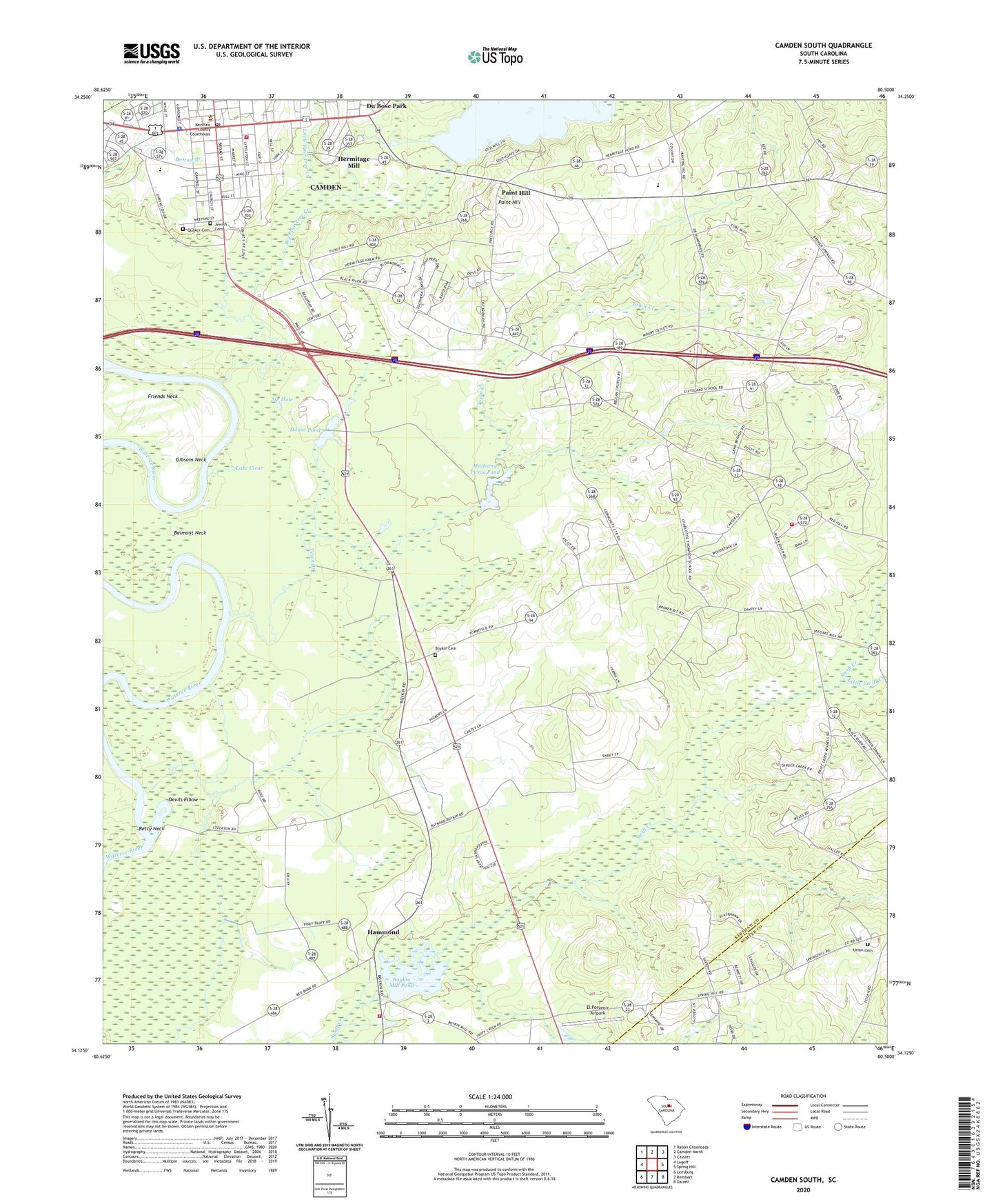
2020 topographic map quadrangle Camden South in the state of South Carolina. Scale: 1:24000. Based on the newly updated USGS 7.5' US Topo map series, this map is in the following counties: Kershaw, Sumter. The map contains contour data, water features, and other items you are used to seeing on USGS maps, but also has updated roads and other features. This is the next generation of topographic maps. Printed on high-quality waterproof paper with UV fade-resistant inks.
Quads adjacent to this one:
West: Lugoff
Northwest: Rabon Crossroads
North: Camden North
Northeast: Cassatt
East: Spring Hill
Southeast: Dalzell
South: Rembert
Southwest: Leesburg
Contains the following named places: Antioch School, Belmont Neck, Bethel Pentecostal Holiness Church, Bethseda Presbyterian Church, Betty Neck, Beulah Church, Beulan Church, Big Pine Tree Creek, Boykin Cemetery, Boykin Division, Boykin Mill Pond, Boykin School, Boykins Mill, Browning Home and Mather Academy, Buckton Plantation, Burrows Tract, Camden, Camden City Hall, Camden Fine Arts Center, Camden Fire Department, Camden Middle School, Camden Post Office, Cantys Lane, Carrison Mill, Carter Hill Plantation, Charlotte Thompson School, Church of Christ, City of Camden Historic District, Cleveland School, Cleveland School Monument, Deloach, Devils Elbow, Du Bose Park, East Camden Church of God, El Porvenir Airpark, Ellerbee, Emmanuel Church, English Mill, English Plantation, Fairholm Plantation, First Baptist Church, Fralo Farm, Frank Martin Pond Dam D-2504, Friends Neck, Gibsons Neck, Graham Pond, Graham Pond Dam D-2503, Green Hill Church, Hammond, Hampton Park, Hermitage Church, Hermitage Farm, Hermitage Mill, Hermitage Mill Pond, Hermitage Mill Pond Dam, Hillard Plantation, House Pond, Jackson Elementary School, Jackson High School, Jackson Park, Jewish Cemetery, Kershaw County Courthouse, Kershaw County Fire Department Boykin Station, Kershaw County Fire Station Charlotte Thompson, Kershaw County Jail, Kershaw County Library, Lake Clear, Legion Park, Little Pine Tree Creek, Little Swift Creek, Lyttleton Street United Methodist Church, Mount Moriah Baptist Church, Mount Olivet Church, Mount Pleasant Plantation, Mount Zion Church, Mulberry House Pond Dam D-2505, Mulberry Picnic Pond, Mulberry Picnic Pond Dam D-2506, Mulberry Plantation, Northwest Junction, Paint Hill, Pine Grove Plantation, Plane Hill Plantation, Pretty Mamas Plantation, Quaker Cemetery, Retriever Training Pond, Rhame Arena, Saint Mathew Church, Saint Mathew School, Sardis Baptist Church, Second Presbyterian Church, Sip Hole, South Carolina Highway Patrol Troop 1 Post B, South Carolina Noname 28006 D-1144 Dam, Southside Baptist Church, Stockton, Stockton School, Swift Creek Baptist Church, Swift Creek School, Tickle Hill, Town Creek, Town Creek Plantation, Trinity United Methodist Church, Union Cemetery, Union Church, Union School, Wesley Chapel, Zemp Field